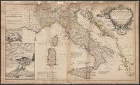
"Note: the post roads in this map are taken from Iacobo Cantelli da Vignola the Duke of Modena's geographer.", *40 1714: verso: stamped "Yale UL"; dgvmp2008., and Includes inset views of Caesium, Vesuvius, Aetna.
Publisher:
printed for H. Moll...Ino. Bowles...T. Bowles...Philip Overton,
Subject (Geographic):
Italy--Maps--Early works to 1800 and Mediterranean Region--Maps--Early works to 1800
Subject (Name):
Bowles, John, 1701-1779, Bowles, Thomas, -1767, Cantelli da Vignola, Giacomo, 1643-1719, and Overton, Philip, -1751
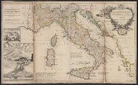
Includes historical notes, text, and insets "A particular map of Baffin and Hudson's Bay" and "The passage by land to California, discover'd by Father Eusebius Francis Kino, a Jesuit; between the years 1698 and 1701, before which, and for a considerable t
Publisher:
Printed for Robt. Sayer, map, chart & printseller,
From George Henry Millar's New complete & universal system of geography. 1782., Inset map: "East Florida continued"., Recto: Numbered "166" (?) in ink ms. Verso: Stamped "Yale Horace Brown 1900S"., and Relief shown pictorially.
Publisher:
Engrav'd for Millar's New complete & universal system of geography,
Harbour of Annapolis Royal, Indian fort Sasquesahanok, and Map of ye mouth of Mississipi and Mobile rivers &c
Description:
Appears in Moll's The world described., Blocks of text offer explanations of various features of the map., Includes notes and ill. of "The Indian Fort Sasquesahanok.", Label, with ms. nos., on verso: 533/9. Hand col. Sheet measures, and Relief shown pictorially.
Publisher:
Sold by H. Moll over against Devereus Court between Temple Bar and St. Clements Church in the Strand ... [and] sold by Tho: Bowles ... Iohn King ... Iohn Bowles,
Subject (Geographic):
North America--Maps--Early works to 1800
Subject (Name):
Bowles, John, 1701-1779, bookseller, Bowles, Thomas, -1767, bookseller, and Moll, Herman, -1732. World described
Harbour of Annapolis Royal, Indian fort Sasquesahanok, and Map of ye mouth of Mississipi and Mobile rivers &c
Description:
Appears in Moll's The world described., Blocks of text offer explanations of various features of the map., Dedicated to Thomas Bromsall., Includes notes and ill. of "The Indian Fort Sasquesahanok.", and Insets: The harbour of Annapolis Royal -- A map of ye mouth
Publisher:
Sold by H. Moll over against Devereus Court between Temple Bar and St. Clements Church in the Strand ... [and] sold by Tho: Bowles ... Iohn King ... Iohn Bowles,
Subject (Geographic):
North America--Maps--Early works to 1800
Subject (Name):
Bowles, John, 1701-1779, bookseller, Bowles, Thomas, -1767, bookseller, and Moll, Herman, -1732. World described