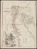
Robert de Vaugondy, Gilles, 1688-1766, cartographer
Call Number:
61 1799A
Container / Volume:
BRBL_00330
Image Count:
1
Resource Type:
Maps, Atlases & Globes
Description:
Appeared in the Gilles and Didier Robert de Vaugondy's Atlas universel., Borders are hand colored., Printed number on verso: 106., Relief shown by hachures., and Watermark.
Subject (Geographic):
Egypt--Historical geography--Maps--Early works to 1800 and Egypt--Maps--Early works to 1800
Subject (Name):
Robert de Vaugondy, Didier, 1723-1786. Atlas universel and Robert de Vaugondy, Gilles, 1688-1766. Atlas universel
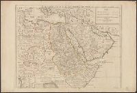
Ancillary map: Ethiopie au dessus de l'Egypte., From Alexandre Delamarche's Atlas de geographie ancienne, du moyen âge et moderne., In lower right corner: 9.10., and Relief shown by hachures.
Publisher:
[Félix Delamarche],
Subject (Geographic):
Egypt--Historical geography--Maps and Palestine--Historical geography--Maps
Subject (Name):
Delamarche, Alexandre, 1815-1884. Atlas de la géographie ancienne, du moyen age, et moderne.
"Avec privilege pour 20 ans.", Covers Africa east of Algeria and north of the equator., Has watermark., Includes text., Relief shown pictorially., and Sheet measures 54 x 73 cm. Ms. no. on verso: 77.
Publisher:
Chez l'auteur sur le Quai de l'Horloge a l'Aigle d'Or,
"Avec privilege pour 20 ans.", Covers Africa east of Algeria and north of the equator., Has watermark., Includes text., Relief shown pictorially., and Sheet measures 54 x 73 cm. Ms. no. on verso: 77.
Publisher:
Chez l'auteur sur le Quai de l'Horloge a l'Aigle d'Or,
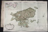
Bellin, Jacques Nicolas, 1703-1772, creator France, Depot des cartes et plans de la marine
Published / Created:
1763
Call Number:
2003 Folio 85
Image Count:
1
Alternative Title:
Carte d'une partie de l'isle de Terre Neuve et les isles de St. Pierre et Miquelon [scale ca. 1:666,666]
Description:
BEIN 2003 Folio 85: No. 12 of 45 maps bound together with binder's spine title: Atlas of America; ms. table of contents. Bookplate: Robinson. Bookplate of Paul Mellon., Hand colored., par le S. Bellin ingenieur de la marine et du Depost M.DCC.LXIII., and Scale [ca. 1:15,400].
Publisher:
DeÌpost des cartes et plans de la marine
Subject (Geographic):
Newfoundland and Labrador -- Maps -- Early works to 1800 and Saint Pierre and Miquelon -- Maps -- Early works to 1800
Atlas Universel de Géographie Physique et Politique, Ancienne et Moderne, 1798.
Description:
"no. 138" in upper right corner. and Appears in: " Atlas Universel de Géographie Physique et Politique, Ancienne et Moderne" / par E. Mentelle ...1798.
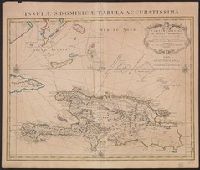
"Lieues marines Fr, Also shows southern part of Bahamas and Turks and Caicos Islands., Appears in de L'Isle's Atlas nouveau., Cross Collection no. 268., Ms. no. on verso: 10A., and Relief shown pictorially. Depths shown by shading.
Publisher:
Chez Jean Cóvens et Corneille Mortier, geographes,
Subject (Geographic):
Bahamas--Maps--Early works to 1800, Hispaniola--Maps--Early works to 1800, and Turks and Caicos Islands--Maps--Early works to 1800
Subject (Name):
Cóvens et Mortier, Frézier, Amédée François, 1682-1773, and L'Isle, Guillaume de, 1675-1726. Atlas nouveau