Skip to search
Skip to main content
Skip to first result
Search
You Searched For
Extent of Digitization
Completely digitized
Publication Place
London :
New Search
Search Results
Published / Created:
1909
Call Number:
32 L84 1835
Container / Volume:
BRBL_00050
Image Count:
1
Resource Type:
Maps, Atlases & Globes
Description:
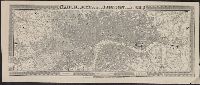
Originally published: London, G.F. Cruchley, 1835. and Reproduction.
Publisher:
Adam & Charles Black,
Subject (Geographic):
London (England)--Maps
Found in:
Beinecke Rare Book and Manuscript Library > Cruchley's new plan of London improved to 1835.
Published / Created:
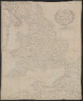
1831
Call Number:
32 1831
Container / Volume:
BRBL_00045
Image Count:
1
Resource Type:
Maps, Atlases & Globes
Description:
Preliminary record. and Printed on cloth.
Publisher:
Engraved & Published by Cruchley,
Subject (Geographic):
England--Maps
Found in:
Beinecke Rare Book and Manuscript Library > Cruchley's new travelling map and itinerary comprising the whole of England ...
Creator:
Call Number:
3221gme 1845
Container / Volume:
BRBL_00059
Image Count:
2
Resource Type:
Maps, Atlases & Globes
Alternative Title:
Cruchley's railway and station map of the county of Suffolk, Railway and station map of Suffolk, and Railway and station map of the county of Suffolk
Description:
"This map may be had geologically coloured.", Edition statement from front wrapper., and Imperfect: torn along folds, with some loss of text. Original wrappers. Inscription in upper left corner of map: Hist. of Madleigh, Dr. Rev. Hugh Pigot, M.A., Curate of Mad
Publisher:
G.F. Cruchley,
Subject (Geographic):
Suffolk (England)--Maps.
Subject (Name):
Townsend, H. H.--Autograph.
Found in:
Beinecke Rare Book and Manuscript Library > Cruchley's railway and station map of Suffolk : showing all the railways & names of stations, also the turnpike roads, gentlemens seats, &c. &c.L65, improved from ordnance surveys.
Creator:
Published / Created:
[ca. 1860].
Call Number:
3224 1860
Container / Volume:
BRBL_00060
Image Count:
1
Resource Type:
Maps, Atlases & Globes
Alternative Title:
Cruchley's railway and telegraphic county maps of England. 36
Description:
Relief shown by hachures.
Publisher:
G.F. Cruchley,
Subject (Geographic):
Warwickshire (England)--Maps
Subject (Topic):
Railroads--England--Warwickshire--Maps
Found in:
Beinecke Rare Book and Manuscript Library > Cruchley's railway and station map of Warwick showing all the railways & names of stations, also the turnpike roads, gentlemens seats, &c. &c. improved from the Ordnance Surveys.
Published / Created:
[ca. 1673]
Call Number:
BrSides By6 1673
Image Count:
1
Description:
Begins: God Cupid's unkind ...
Publisher:
Printed for VV. Thackeray, T. Passenger, and VV. Whitwood,
Subject (Topic):
Brit Tracts--1673
Found in:
Beinecke Rare Book and Manuscript Library > Cupid's master-piece, or, Long wisht for comes at last, or, The happy meeting of William and Mary ... : tune of, Caelia's my foe ...
Published / Created:
1683
Call Number:
BrSides By6 1683
Image Count:
1
Alternative Title:
Dagon's fall. and The whig's lamentation for the death of Anthony, King of Poland.
Description:
Printed in 2 columns., Reprinted in Roxburgh ballads, v. 5, p. 234-235., and Satire in verse on the Earl of Shaftesbury.
Publisher:
Printed by Nath. Thompson,
Subject (Geographic):
Great Britain--Politics and government--1660-1688--Sources
Subject (Name):
Shaftesbury, Anthony Ashley Cooper,--Earl of,--1621-1683
Subject (Topic):
Brit tracts--1683
Found in:
Beinecke Rare Book and Manuscript Library > Dagon's fall, or, The whigs lamentation for the death of Anthony, King of Poland : to the tune of, Philander, &c.
Creator:
Published / Created:
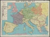
[1941?]
Call Number:
11hd 1939B
Image Count:
1
Resource Type:
Maps, Atlases & Globes
Alternative Title:
Daily express (London, England) and Daily Express war map of Europe
Description:
Prime meridian: Greenwich. and Wall map of wartime Europe showing beligerent countries (United Kingdom, France, Poland, Germany, Danzig, Soviet Russia), neutral countries, the Maginot Line, the Siegfried Line and European wartime resources.
Publisher:
Printed in Great Britain by George Philip & Son,
Subject (Geographic):
Europe--Maps, Maginot Line (France)--Maps, and Siegfried Line (Germany)--Maps
Subject (Topic):
World War, 1939-1945--Europe--Maps
Found in:
Beinecke Rare Book and Manuscript Library > Daily Express war map [cartographic material] / the London Geographical Institute KCL.
Creator:
Published / Created:
[1914.]
Call Number:
11hc 1915B
Image Count:
2
Resource Type:
Maps, Atlases & Globes
Alternative Title:
The Franco-Belgian Theatre of War
Description:
"The London Geographical Institute." printed outside lower right margin., Includes inset map "South East continuation of the Map on same scale.", and On verso: Key Map to the General European Situation, adv. and ill.
Publisher:
G. Philips & Son, Ltd.,
Subject (Geographic):
Belgium--Maps and France--Maps
Subject (Topic):
World War, 1914-1918--Maps
Found in:
Beinecke Rare Book and Manuscript Library > Daily Mail large-scale Military maps No. 3. : The Franco-Belgian Theatre of War / edited by George Philip, F.R.G.S., in conjunction with Military experts.
Creator:
Published / Created:
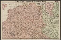
1941
Call Number:
11hd 1941
Image Count:
1
Resource Type:
Maps, Atlases & Globes
Alternative Title:
Daily telegraph (London, England), Daily Telegraph war map ; no. 6, Daily Telegraph war map ; no. 6., and War map of the Russian Front
Description:
"Specially prepared for the Daily Telegraph by the London Geographical Institute.", Also shown oil-fields, oil pipe lines, naval bases, railways, canals, and shipping routes., and Wall map showing territories of United Kingdom and "British Empire, Soviet Russia
Publisher:
Printed in Great Britain by George Philip & Son,
Subject (Geographic):
Europe--Maps and Russia (Federation)--Maps
Subject (Topic):
World War, 1939-1945--Eastern front--Maps
Found in:
Beinecke Rare Book and Manuscript Library > Daily Telegraph war map of the Russian Front [cartographic material] / London Geographical Institute.
Published / Created:
[1840?]
Call Number:
32 Ox1 1840
Container / Volume:
BRBL_00052A
Image Count:
1
Resource Type:
Maps, Atlases & Globes
Description:
Preliminary record.
Publisher:
Wm. Darton & Son,
Subject (Geographic):
Oxford (England)--Maps
Found in:
Beinecke Rare Book and Manuscript Library > Darton's Environs of Oxford, including London, East. Huntingdon, North. Chetenham, West and Andover South of the City of Oxford.
Branch:v1.61.6 ,Deployed:2024-06-12T09:55:19-04:00