Skip to search
Skip to main content
Skip to first result
Search
You Searched For
Resource Type
Maps, Atlases & Globes
Language
Latin
New Search
Search Results
Published / Created:
1572]
Call Number:
32am C14 1572
Container / Volume:
BRBL_00074
Image Count:
2
Resource Type:
Maps, Atlases & Globes
Subject (Geographic):
England--Maps--Early works to 1800
Found in:
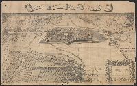
Beinecke Rare Book and Manuscript Library > Canterbrigia, o pulentiffimi Anglie Regni, orbs celeberrimi nominis, ab Academie conditore Cantabro, Cognominata: A Granta, fluvio vicino, Cairgrant; saxonib. Graunteces fre, Grantebrige iam olim nuncupata.
Published / Created:
1572]
Call Number:
32am C14 1572
Container / Volume:
BRBL_00074
Image Count:
1
Resource Type:
Maps, Atlases & Globes
Subject (Geographic):
England--Maps--Early works to 1800
Found in:
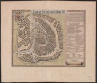
Beinecke Rare Book and Manuscript Library > Canterbrigia, o pulentiffimi Anglie Regni, orbs celeberrimi nominis, ab Academie conditore Cantabro, Cognominata: A Granta, fluvio vicino, Cairgrant; saxonib. Graunteces fre, Grantebrige iam olim nuncupata.
Published / Created:
[1680?]
Call Number:
41 1680
Container / Volume:
BRBL_00241
Image Count:
2
Resource Type:
Maps, Atlases & Globes
Alternative Title:
Carinthiae dvcatvs, et Goritiae palatinatvs, Histriæ tabula à Petro Cappo ..., and Zarae, et Sebenici descriptio
Subject (Geographic):
Austria--Maps--Early works to 1800 and Hungary--Maps--Early works to 1800
Found in:
Beinecke Rare Book and Manuscript Library > Carinthiae ducatus, et Goritiae palatinatus / Wolf. Lazio auctore.
Published / Created:
1691
Call Number:
40AM C21 1691
Container / Volume:
BRBL_00227
Image Count:
1
Resource Type:
Maps, Atlases & Globes
Subject (Geographic):
Carmagnola (Italy)--Maps--Early works to 1800
Found in:
Beinecke Rare Book and Manuscript Library > Carmagnoli ingenomen in 1691. Prise en 1691 Door Syn Ht. Den Par S.A.S. le Pr. Eugenius Van Pr. Eugene de Savoye.
Creator:
Published / Created:
1663?]
Call Number:
352 M85 1663
Container / Volume:
BRBL_00733
Image Count:
2
Resource Type:
Maps, Atlases & Globes
Description:
Appears in Blaeu's Atlas major, Fre, Hand col. Sheet measures 54 x 63 cm. Lanman Collection., Russian, Latin and French., Title text in cyrillic; transliteration in Koeman., and Verso: Title "Moskow, ville metropolitaine de Moscovie"; pg. no. 20,b; signature F 2.
Publisher:
Joan Blaeu,
Subject (Geographic):
Moscow (Russia)--Maps--Early works to 1800
Found in:
Beinecke Rare Book and Manuscript Library > Carstvajuscoi grad moskva nacal'noi gorod vseh moskovskih gosudarstv.
Published / Created:
[1700]
Call Number:
898 1700
Container / Volume:
BRBL_00660
Image Count:
1
Resource Type:
Maps, Atlases & Globes
Description:
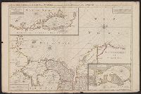
From le Neptune francois, Amsterdam, P. Mortier 1693-1700. and Insets: 1. "Rade de Darien et les Isles aux Environs." 2. " Carte de la Rade de Cartagene et des Environs & g."
Subject (Geographic):
Panama--Maps--Early works to 1800
Found in:
Beinecke Rare Book and Manuscript Library > Carte Particuliere de Isthmus, ou Darien, qui comprend le Golfe de Panama & c. Cartagene, et les isles aux environs. A Amsterdam chez Pierre Mortier avec Privilege.
Creator:
Published / Created:
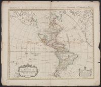
1774
Call Number:
70 1774A
Container / Volume:
BRBL_00724
Image Count:
1
Resource Type:
Maps, Atlases & Globes
Alternative Title:
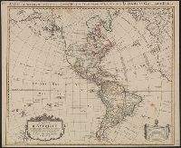
America accurate in imperia, regna, status, et populos divisa, ad usum Ludovici XV. Galliarum Regis
Description:
In French, with additional title in Latin., Includes "Avertissement"., Relief shown pictorially., and Sheet measures 51.5 x 63 cm. Numbered "108" in ink ms. Franklin Collection.
Publisher:
Chez Covéns & Mortier & Covéns Junior,
Subject (Geographic):
America--Maps--Early works to 1800
Subject (Name):
Anville, Jean Baptiste Bourguignon d', 1697-1782, Condet, Johannes, 1711-1781, engraver, and Covens et Mortier et Covens, junior
Found in:
Beinecke Rare Book and Manuscript Library > Carte d'Amerique : divisées en ses principales parties / par G. Delisle, premier geographe du Roy, rectifiée apres les nouvelles observations du Sr. D'Anville et autres geographes ; J. Condet, sc.
Creator:
Published / Created:
1774
Call Number:
70 1774A
Container / Volume:
BRBL_00356
Image Count:
1
Resource Type:
Maps, Atlases & Globes
Alternative Title:
America accurate in imperia, regna, status, et populos divisa, ad usum Ludovici XV. Galliarum Regis
Description:
In French, with additional title in Latin., Includes "Avertissement"., Relief shown pictorially., and Sheet measures 58.5 x 69 cm. Stamp on verso: "Yale Horace Brown 1900S".
Publisher:
Chez Covéns & Mortier & Covéns Junior,
Subject (Geographic):
America--Maps--Early works to 1800
Subject (Name):
Anville, Jean Baptiste Bourguignon d', 1697-1782, Condet, Johannes, 1711-1781, engraver, and Covens et Mortier et Covens, junior
Found in:
Beinecke Rare Book and Manuscript Library > Carte d'Amerique : divisées en ses principales parties / par G. Delisle, premier geographe du Roy, rectifiée apres les nouvelles observations du Sr. D'Anville et autres geographes ; J. Condet, sc.
Creator:
Call Number:
51 1705
Container / Volume:
BRBL_00278
Image Count:
1
Resource Type:
Maps, Atlases & Globes
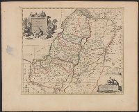
Description:
Borders are hand colored., In upper right corner: "Dans le N. Testament pag. 20.", Includes three bar scales., and Relief shown pictorially.
Subject (Geographic):
Palestine--Historical geography--Maps--Early works to 1800
Subject (Name):
Luchtenburg, Johannes van, engraver
Subject (Topic):
Bible.--O.T.--Geography--Maps--Early works to 1800
Found in:
Beinecke Rare Book and Manuscript Library > Carte de la Terre Sainte : divisée selon les douze tribus d'Isreal ou sont exactement marquez les voyages de Iésus Christ &c. : dressée pour bien entendre les histoires de la Bible / par le sain de Pierre Mortier ; I. van Luchtenburg delin. et schulp.
Published / Created:
[1665?]
Call Number:
57 OS2 1665
Container / Volume:
BRBL_00304
Image Count:
1
Resource Type:
Maps, Atlases & Globes
Description:
From: Monumenta Cartographica. I. 21. and Preliminary record.
Subject (Geographic):
Japan--Maps--Early works to 1800
Found in:
Beinecke Rare Book and Manuscript Library > Casteel Osacca. [By J. Vingboons].
Branch:v1.61.8 ,Deployed:2024-06-20T11:14:55-04:00