Department of State publication ; 803. and Department of State, map series ; no. 5 (Publication no. 803)
Description:
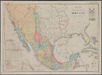
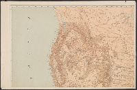
"Reproduced in 1935 to accompany ʻTreaties and other international acts of the United States of America,ʾ Volume 5. See Document 129.", "The earliest of five or more 1847 editions. The copy added to the Treaty of Guadalupe Hidalgo of February 2, 1848, in the archives of the Department of State.", Includes table of distances, table of statistics, "Profile of the route between Mexico and Vera Cruz," and "Profile of the route b[e]tween Mexico and Acapulco.", Insets: Carta de los caminos &c. desde Vera Cruz y Alvarado a Méjico -- Map showing the battle grounds of the 8th and 9th May 1846 -- Chart of the bay of Vera Cruz., Prime meridian: Washington., and Relief shown by hachures and spot heights.
[Maury map collection ; Series A5], South Pacific, Wind and current chart of the South Pacific, and Wind and current chart, South Pacific
Description:
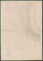
"[Engraved by] Oliver J. Stuart. N.Y."--Sheet 8, lower right margin., "Eng. by Sherman & Smith N.Y."--Sheet 10, lower right margin., Shows prevailing wind direction by month., and Similar wind and current charts of other oceans compiled from materials in the Bur
Publisher:
United States Hydrographical Office,
Subject (Geographic):
South Pacific Ocean--Charts, diagrams, etc
Subject (Name):
Gibbon, Lardner, Maury, Matthew Fontaine, 1806-1873. Wind and current charts, Sherman & Smith, Stuart, Oliver J, United States Naval Observatory, United States. Bureau of Ordnance and Hydrography, United States. Hydrographic Office, and Wells, C. H
[Maury map collection ; Series A5], South Pacific, Wind and current chart of the South Pacific, and Wind and current chart, South Pacific
Description:
"[Engraved by] Oliver J. Stuart. N.Y."--Sheet 8, lower right margin., "Eng. by Sherman & Smith N.Y."--Sheet 10, lower right margin., DLC, Includes, Shows prevailing wind direction by month., and Various eds. of some sheets with updated and additional information.
Publisher:
United States Hydrographical Office,
Subject (Geographic):
South Pacific Ocean--Charts, diagrams, etc
Subject (Name):
Gibbon, Lardner, Maury, Matthew Fontaine, 1806-1873. Wind and current charts, Sherman & Smith, Stuart, Oliver J, United States Naval Observatory, United States. Bureau of Ordnance and Hydrography, United States. Hydrographic Office, and Wells, C. H
[Maury map collection ; Series A3], Indian Ocean, and Wind and current chart, Indian Ocean
Description:
"Drawn by R.H. Wyman & G. B. Balsh, lieutenants, U.S. , April 1854"--Sheet 5, lower margin., "Series A.", and Copy imperfect: All sheets fold lined, with some tears along fold-line. Sheets 5-11discoloration throughout. Sheet 5 torn and repaired in lower right c
Publisher:
United States Hydrographical Office,
Subject (Geographic):
Indian Ocean--Maps
Subject (Name):
Balsh, G. B, Johnson, A. W, Maury, Matthew Fontaine, 1806-1873. Wind and current charts, United States. Hydrographic Office, Wells, C. H, Welsh, George P., -1860, and Wyman, R. H. (Robert Harris), 1822-1882
Insets: maps of the Territory of Alaska; [and] West Indies and Isthus of Darien., Prime meridian: Washington., and Relief shown by hachures and spot heights.