Skip to search
Skip to main content
Skip to first result
Search
You Searched For
Format
cartographic
Publication Place
Chicago :
New Search
Search Results
Creator:
Published / Created:
[1937]
Call Number:
845 1937
Container / Volume:
BRBL_00620
Image Count:
2
Resource Type:
Maps, Atlases & Globes
Alternative Title:
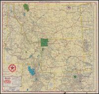
Idaho, Montana, Wyoming, and North & South Dakota, Texaco road map, Idaho, Montana, Wyoming., and Texaco road map, North Dakota, South Dakota.
Description:
"S.2721.", "S.3227.", Includes indexes, text, ill., and maps of "Yellowstone National Park" and "Waterton-Glacier International Peace Park.", Panel title., Relief shown by hachures and spot heights., and Texaco road map, Idaho, Montana, Wyoming -- Texaco road map, North Dakota, South Dakota.
Publisher:
Rand McNally,
Subject (Geographic):
West (U.S.)--Maps
Subject (Topic):
Roads--West (U.S.)--Maps
Found in:
Beinecke Rare Book and Manuscript Library > Texaco touring map, Idaho, Montana, Wyoming, and North & South Dakota.
Creator:
Published / Created:
1911
Call Number:
796 1911
Container / Volume:
BRBL_00526
Image Count:
1
Resource Type:
Maps, Atlases & Globes
Alternative Title:
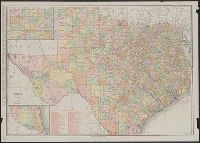
New business atlas map of Texas and Rand McNally & Co.'s new business atlas map of Texas
Description:
Includes insets of the panhandle and southern Texas, and indexes. and Relief shown by hachures and spot heights.
Publisher:
Rand McNally,
Subject (Geographic):
Texas Panhandle (Tex.)--Maps and Texas--Maps
Subject (Topic):
Railroads--Texas--Maps
Found in:
Beinecke Rare Book and Manuscript Library > Texas.
Creator:
Published / Created:
1888
Call Number:
75gme 1888
Container / Volume:
BRBL_00414
Image Count:
1
Resource Type:
Maps, Atlases & Globes
Description:
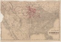
Rail connections to Duluth shown in red. and Shows railroad lines and stations across United States.
Publisher:
Rand, McNally & Co.,
Subject (Geographic):
United States--Maps
Subject (Topic):
Railroads--Minnesota--Maps and Railroads--United States--Maps
Found in:
Beinecke Rare Book and Manuscript Library > The Duluth daily news map of the Duluth railway system : Showing lines completed, under construction, and projected, Jan. 1st, 1888.
Creator:
Published / Created:
1873
Call Number:
75 1873
Container / Volume:
BRBL_00405
Image Count:
2
Resource Type:
Maps, Atlases & Globes
Description:
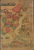
Across top of map: "Panoramic view of the country between San Francisco and St. Louis.", Includes ill., text, population information, and inset of "Central America.", Prime meridians: Washington and Greenwich., and Relief shown by hachures.
Publisher:
Geo. F. Cram,
Subject (Geographic):
United States--Maps
Subject (Topic):
Railroads--United States--Maps
Found in:
Beinecke Rare Book and Manuscript Library > The Improved American Union Railroad map of the United States, British provinces, West Indies, Mexico and Central America.
Creator:
Published / Created:
c1910.
Call Number:
795 1910
Container / Volume:
BRBL_00521
Image Count:
2
Resource Type:
Maps, Atlases & Globes
Description:
Includes table of navigable waters and inset of "Vicinity of New Orleans." and Text of "An agricultural and physiological description of Louisiana" on verso.
Publisher:
Geo. F. Cram,
Subject (Geographic):
Louisiana--Maps
Subject (Name):
Cram, George Franklin, 1841-1928
Subject (Topic):
Phytogeography--Louisiana--Maps
Found in:
Beinecke Rare Book and Manuscript Library > The Louisiana State Board of Agriculture and Immigration's map of Louisiana : a phytogeographic map showing the principal vegetation areas, all principal commercial points, town populations and railway distances / issued by Hon. E.O. Bruner, Commissioner,
Creator:
Published / Created:
[1903]
Call Number:
76gme 1903
Container / Volume:
BRBL_00446A
Image Count:
1
Resource Type:
Maps, Atlases & Globes
Abstract:
A color map showing the rail and marine routes operated by the New York, New Haven and Hartford Railroad, as well as connecting routes.
Alternative Title:
Pocket map of the New York, New Haven and Hartford Railroad lines
Description:
"12-4-'03", Covers attached to verso. Not digitized., and Includes insets of the Boston and New York Metropolitan Areas.
Publisher:
Poole Brothers,
Subject (Name):
New York, New Haven, and Hartford Railroad Company--Maps
Subject (Topic):
Ferries--New England--Maps and Railroads--New England--Maps
Found in:
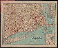
Beinecke Rare Book and Manuscript Library > The New York, New Haven and Hartford Railroad and connections.
Creator:
Published / Created:
1916
Call Number:
786 1916
Container / Volume:
BRBL_00515
Image Count:
1
Resource Type:
Maps, Atlases & Globes
Description:
In left margin: Directory of Principal Cities. In lower right corner [Directory of] South Carolina Railroads. and On verso: Directory of Counties, Creeks, Islands, Rivers and Towns.
Publisher:
Rand McNally,
Subject (Geographic):
South Carolina--Maps
Subject (Topic):
Railroads--South Carolina--Maps
Found in:
Beinecke Rare Book and Manuscript Library > The Rand McNally New Commercial Atlas Map of South Carolina.
Creator:
Published / Created:
[1919?]
Call Number:
30 1920D
Container / Volume:
BRBL_00032
Image Count:
1
Resource Type:
Maps, Atlases & Globes
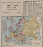
Alternative Title:
New Europe.
Description:
"124E.", Includes text: Summary of the treaty of peace., and Relief shown by hachures.
Publisher:
Rand McNally,
Subject (Geographic):
Europe--Boundaries--Maps
Subject (Topic):
World War, 1914-1918--Territorial questions--Maps
Found in:
Beinecke Rare Book and Manuscript Library > The Rand McNally map of new Europe.
Creator:
Published / Created:
[1917?]
Call Number:
787 1916
Container / Volume:
BRBL_00517
Image Count:
2
Resource Type:
Maps, Atlases & Globes
Alternative Title:
Rand-McNally vest pocket map of Georgia
Description:
Index begins on map verso, continues in accompanying index booklet. and Relief shown by hachures.
Publisher:
Rand McNally & Co.,
Subject (Geographic):
Georgia--Maps
Subject (Topic):
Railroads--Georgia--Maps
Found in:
Beinecke Rare Book and Manuscript Library > The Rand McNally new commercial atlas map of Georgia / Rand McNally & Co.
Creator:
Published / Created:
1914, c1902.
Call Number:
806 1914
Container / Volume:
BRBL_00547
Image Count:
1
Resource Type:
Maps, Atlases & Globes
Alternative Title:
New commercial atlas map of Illinois.
Description:
Includes list of Alabama Railroads, and index., ms. notations in red, green and pencil. Imperfect: pamphlet wanting., and Title of accompanying pamphlet: The Rand-McNally indexed county and township pocket map and shippers' guide of Illinois: showing railroads,
Publisher:
Rand McNally and Co.,
Subject (Geographic):
Illinois--Maps
Subject (Topic):
Railroads--Illinois--Maps
Found in:
Beinecke Rare Book and Manuscript Library > The Rand McNally new commercial atlas map of Illinois [cartographic material].
Branch:v1.61.8 ,Deployed:2024-06-20T11:15:02-04:00