Rand, McNally & Co.'s road map of the New York and New Jersey suburbs and Road map of the New York and New Jersey suburbs
Description:
Imperfect: mutilated, with some loss of text., Includes list of addresses of places of interest and inset of Lower Manhattan., and Relief shown by hachures and spot heights.
Rand McNally and Co.'s Indexed atlas of the world.
Container / Volume:
BRBL_00500
Image Count:
1
Resource Type:
Maps, Atlases & Globes
Alternative Title:
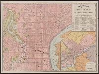
Philadelphia and vicinity. and Rand McNally & Co.'s new business atlas map of Philadelphia.
Description:
"90, 91.", At head of title and top of map: Rand McNally & Co.'s indexed Atlas of the world., Includes index of piers and their ownership on Delaware River., Inset: Philadelphia and vicinity. Scale [ca. 1:120,000]., and On verso: [part of gazetteer listing for Pe
Publisher:
Rand McNally,
Subject (Geographic):
Philadelphia (Pa.)--Maps and Philadelphia Metropolitan Area (Pa.)--Maps
Subject (Name):
Rand McNally and Company. Rand McNally & Co.'s indexed atlas of the world
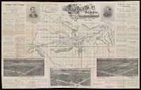
Union Pacific System map of Rocky Mountain National (Estes) Park, Denver Mountain parks
Description:
"3-8-'22.", "6062.", "Union Pacific System" at head of title., Includes inset showing "Union Pacific System and connections.", and Relief shown by shading and spot heights.
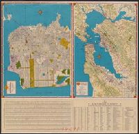
Metropolitan San Francisco and vicinity., Shell map of San Francisco, Oakland and vicinity, Shell metropolitan San Francisco and vicinity., Shell street map of Bay cities., Shell street map of San Francisco., Street map of Bay cities., and Street map of San Francis
Description:
"1940-1", Index and text on verso., Indexed., Panel title., Relief shown by shading, hachures, and spot heights., and Street map of San Francisco -- Metropolitan San Francisco and vicinity -- Street map of Bay cities.
Publisher:
H.M. Goushá Co.,
Subject (Geographic):
Oakland Metropolitan Area (Calif.)--Maps, San Francisco (Calif.)--Maps, and San Francisco Bay Area (Calif.)--Maps
Subject (Name):
Shell Union Oil Corporation
Subject (Topic):
Roads--California--Oakland Metropolitan Area--Maps, Roads--California--San Francisco Bay Area--Maps, and Streets--California--San Francisco--Maps
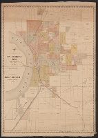
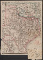
Rand, McNally & Co.'s Texas and Indian Territory and Texas and the Indian Territory
Description:
Includes map of western portion of Texas., Library's copy annotated in red ink and blue pencil., Library's copy attached to map showing, Prime meridians: Greenwich and Washington., Relief shown by hachures., and Shows county outlines, county seats, and railroads.
Publisher:
Rand, McNally & Co.,
Subject (Geographic):
Indian Territory--Maps, Texas--Administrative and political divisions--Maps, and Texas--Maps
Subject (Topic):
Railroads--Indian Territory--Maps, Railroads--Texas--Denison--Maps, and Railroads--Texas--Maps