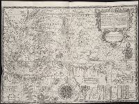
Bat. cum Privil. Ordin. Gener, Belgii Faederati--Title cartouche., Features include ornate title cartouche (top left) with cherubs, male and female figures and royal coat-of-arms supported by lion and unicorn, arms of Scotland supported by cherubs (above scale cartouche at top right), compass indicator and coasts shaded outwards., In Latin with some place names in English; explanations and title for index to places in Dutch and English., No. 7 of 69 maps bound together in composite atlas., Relief shown pictorially., Scale [ca. 1:960 000]., Scale statement reads: Milliaria Germanica Communia 15 in uno Gradu, with scale bar graded [0]-10; Milliaria Scotica Communia quorum 50 in uno Gradu, with scale bar graded [0]-34; Milliaria Gallica quae et Horae Itineris 20 in uno Gradu, with scale bar graded [0]-14., Shows grid, rivers and tributaries, lochs (shaded), trees, place and county names, settlements (symbols classified by importance in legend), territorial boundaries., Shows Scotland including the Hebrides and Orkney Islands., and The four cardinal points are written in the borders.
"Iohan. Senex scu, Imprint derived from other maps in the same atlas., London meridian., Ms. no. on verso: 34. Sheet measures 53 x 68 cm. Cross Collection no. 96., Relief shown pictorially., and Shows boundaries, forests, rivers, roads and settlements, with notes.
Publisher:
John Senex,
Subject (Geographic):
Mediterranean Region--Historical geography--Early works to 1800--Maps
Subject (Name):
Senex, John, d. 1740. New general atlas
Subject (Topic):
Ecclesiastical geography--Africa, North--Maps--Early works to 1800
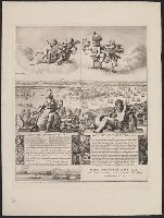
Appears on sheet Die Englische Colonie-Laender ... [Nürnberg] : Homaennische Erben, [ca. 1740], with, Cross Collection no. 282., Relief shown pictorially., and Title in Latin, explanations in German, and map locations in English.
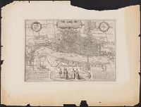
"The Topographic Etching Co., ph. sc.", Alternate title: London, 1572, by Braun and Hogenberg., Bird's-eye-view., Facsimile., Has watermark., Includes 2 texts in Latin, 2 coats of arms, and illus. of human figures., Place names in English., and Reproduced from Braun
Publisher:
Topographical Society of London,
Subject (Geographic):
London (England)--Aerial views--Early works to 1800--Facsimiles
Subject (Name):
Hogenberg, Frans, approximately 1539-1590, joint author and London Topographical Society
"A facsimile of the probably unique example of the original edition in the, Accompanied by title sheet with text. 1 l., Alternate title: View of London by C. J. Visscher, A.D. 1616., Has watermark., and Sheet 1 has: Reproduced by the Typographic Etching Company.
Publisher:
Topographical Society of London,
Subject (Geographic):
London (England)--Aerial views--Early works to 1800--Facsimiles and London (England)--Pictorial works--Early works to 1800--Facsimiles
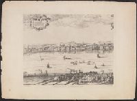
"Emery Walker, ph. sc.", Alternate title: London, Westminster & Southwark, drawn and engraved by Wenceslaus Hollar., Facsimile., Has watermark., Includes text in Latin, inset view of Westminster, city of London coat of arms, and illus., and Panorama.
Publisher:
Cornelius Danckers, and London Topographical Society,
Subject (Geographic):
London (England)--Aerial views--Early works to 1800--Facsimiles and London (England)--Pictorial works--Early works to 1800--Facsimiles
Subject (Name):
Danckerts, Cornelis, 1561-1634 and London Topographical Society
Homann Erben (Firm) Homann, Johann Baptist, 1663-1724
Published / Created:
1729
Call Number:
1975 Folio 31
Collection Title:
[Atlas factice of 42 maps, produced by the Homann Erben firm]
Image Count:
1
Alternative Title:
General map of Great Britain and Ireland with part of Holland, Flanders France &c. agreable to modern history by the heirs of late Mr. Homann at Nuremburg, priviledged by Emperours Majesty
Publisher:
Homann Erben
Subject (Geographic):
Great Britain --Maps --Early works to 1800 and Ireland --Maps --Early works to 1800