Homann Erben (Firm) Homann, Johann Baptist, 1663-1724
Published / Created:
ca. 1741
Call Number:
1975 Folio 31
Collection Title:
[Atlas factice of 42 maps, produced by the Homann Erben firm]
Image Count:
2
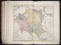
Alternative Title:
Allemagne distinguee en ses cercles & subdivisee en ses etats, contenant son etendue presente rectifiee & methodiquement enluminee suivant les elements de geographie de Mr. Schatz a 1741 avec privilege imperial and Imperii Romano Germanici in suos status et circulos divisi tabula generalis
Publisher:
Homann Erben?
Subject (Geographic):
Austria --Maps --Early works to 1800, Czechoslovakia --Maps --Early works to 1800, Germany --Maps --Early works to 1800, Hungary --Maps --Early works to 1800, and Poland --Maps --Early works to 1800
Plaisirs de l’isle enchantee, ou, Les festes, et divertissements du roy, a Versailles, Festes, et diuertissements du roy, a Versailles, and Plaisirs de l’isle enchantee
Description:
1 unnumbered plate by Francois Chauveau, representing entertainments held in 1674 on the termination of the campaign in Franche-Comte., 5 plates, numbered I-V, by Jean Le Pautre, representing the festivities at Versailles on July 18, 1668., 5 unnumbered plates by Jean Le Pautre., Armorial bookplate with motto: Ubique patriam reminisci., Binding with French royal arms (Bourbon)., Nine plates, numbered 1-9, by Israel Silvestre., On spine: Tom. XI., The first series of 9 plates was originally published in 1673 under the title: Les plaisirs de l’isle enchantee ..., The next series of 5 plates was originally published in 1679 under the title: Relation de la feste de Versailles, du 18e juillet mil six cens soixante-huit., The third series of 6 plates was originally published in 1676 under the title: Les divertissemens de Versailles donnez par la roy a toute sa cour, au retour de la conqueste de la Franche-Comte, en l’annee M.DC.LXXIV ..., The three sequences of plates were each originally published separately with text by Andre Felibien., and Two plates have Yale proprietary stamps on verso; all other versos blank.
Subject (Geographic):
France --Court and courtiers --Pictorial works
and France --History --Louis XIV, 1643-1715
Subject (Name):
Chauveau, Francois, 1613-1676, Felibien, Andre, sieur des Avaux et de Javercy, 1619-1695. Divertissemens de Versailles donnez par le roy a toute sa cour au retour de la conqueste de la Franche-Comte en l’annee M.DC.LXXIV, Felibien, Andre, sieur des Avaux et de Javercy, 1619-1695. Plaisirs de l’isle enchantee, Felibien, Andre, sieur des Avaux et de Javercy, 1619-1695. Relation de la feste de Versailles du dix-huitieme juillet mil six cents soixante-huit, Le Pautre, Jean, 1618-1682, and Silvestre, Israel, 1621-1691
No. 13 of 69 maps bound together in composite atlas., Oriented with north towards upper left., Relief shown pictorially., Scale not given., and Title in Latin; place names in French.
[Atlas factice of 50 maps, primarily by Johann Baptist Homann and/or issued by the Homann Erben
Image Count:
1
Alternative Title:
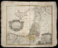
Carte des etats de la Covronne de Pologne
Publisher:
Luci publicae tradita per Homannianos Heredes
Subject (Geographic):
Belarus --Maps --Early works to 1800, Lithuania --Maps --Early works to 1800, Poland --Maps --Early works to 1800, and Ukraine --Maps --Early works to 1800
[Atlas factice of 32 maps and 1 distance table, produced by the Homann Erben firm]
Image Count:
2
Alternative Title:
Carte des etats de la Covronne de Pologne
Publisher:
Luci publicae tradita per Homannianos Heredes
Subject (Geographic):
Belarus --Maps --Early works to 1800, Lithuania --Maps --Early works to 1800, Poland --Maps --Early works to 1800, and Ukraine --Maps --Early works to 1800
Mecometrie de leymant, cest a dire La maniere de mesvrer les longitudes par le moyen de l’eymant
Image Count:
1
Description:
Bound in preceding t.p. for pt. [2] (Premier livre de la Mecometrie arithmetique de l’eymant)., Imperfect: map rubbed, with some loss of map and text., Map has small tear on left edge at gutter., and Scale [ca. 1:100,000,000].
Subject (Topic):
Longitude --Early works to 1800 and World maps --Early works to 1800
Harenberg, Johann Christoph, 1696-1774 Homann Erben (Firm)
Published / Created:
ca. 1750
Call Number:
1983 Folio 23
Collection Title:
[Atlas factice of 50 maps, primarily by Johann Baptist Homann and/or issued by the Homann Erben
Image Count:
1
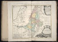
Alternative Title:
Carte de la terre sainte divisee selon les douze tribus d'Israel, Palaestina in XII tribvs divisa cvm terris adiacentibvs, and Regiunculae in quas Palaestina olim fuit divisa delineatae
Publisher:
Curantibus Homanniani Heredibus
Subject (Geographic):
Palestine --History --To 70 A.D --Maps --Early works to 1800
Hase, Johann Matthias, 1684-1742 Homann Erben (Firm) Lowitz, G. M. (George Moritz), 1722-1774
Published / Created:
1746
Call Number:
1975 Folio 31
Collection Title:
[Atlas factice of 42 maps, produced by the Homann Erben firm]
Image Count:
1
Alternative Title:
Mappe-monde qui represente les deux hemispheres savoir celui de l’orient et celui de l’occident, tiree des quatre cartes generales de feu M. le profess. Hasius, dressee par Mr. G.M. Lowitz et publiee par les Heritiers de Homann, avec privil. imper and Planiglobii terrestris mappa vniversalis
Publisher:
Homann Erben
Subject (Topic):
Atlases, German --Early works to 1800, Religion --Maps --Early works to 1800, and World maps --Early works to 1800
Hase, Johann Matthias, 1684-1742 Homann Erben (Firm) Lowitz, G. M. (George Moritz), 1722-1774
Published / Created:
1746
Call Number:
1973 Folio 30
Collection Title:
[Atlas factice of 32 maps and 1 distance table, produced by the Homann Erben firm]
Image Count:
1
Alternative Title:
Mappe-monde qui represente les deux hemispheres savoir celui de l’orient et celui de l’occident, tiree des quatre cartes generales de feu M. le profess. Hasius, dressee par Mr. G.M. Lowitz et publiee par les Heritiers de Homann and Planiglobii terrestris mappa vniversalis
Description:
Map colored to show distribution of religions.
Publisher:
[Homann Erben]
Subject (Topic):
Atlases, German --Early works to 1800, Religion --Maps --Early works to 1800, and World maps --Early works to 1800