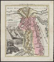
"Joannes Christophorus I.B. Homanni filius delineavit. Cum privilegio Sac. Caes. Majestatis.", Hand col. Sheet measures 65.5 x 56.5 cm., Includes illustrations of cataracts of the Nile, the pyramids, tombs, various antiquities, sce, and Relief shown by hachures.
Appears in Homann Erben's Atlas geographicus major [1759 or 1763?]., Includes ill. and text., Relief shown pictorially., Some text in French., and Yale's card catalog notes "Fock catalogue no. 731 (fr. wh. acquired) gives date as ca. 1730"; and "In Homann J.B. Ne
Publisher:
[Homannianis heredibus?,
Subject (Geographic):
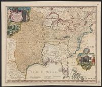
Louisiana--Maps--Early works to 1800 and North America--Maps--Early works to 1800
Subject (Name):
Hennepin, Louis, 17th cent and Homann Erben (Firm). Atlas geographicvs maior
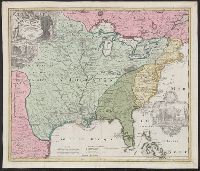
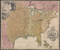
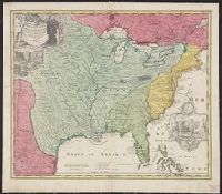
Includes ill. and text., Lowery refers to this version appearing in Homann's Atlas geographicvs maior exhibens tellurem seu globum terraqueum in mappis generalibus & specialibus ... (1759-[1781]), described in Phillips 622. Cf. Lowery 475., and Reference: Antiq
Publisher:
[s.n.,
Subject (Geographic):
Louisiana--Maps--Early works to 1800, Mississippi River Valley--Maps--Early works to 1800, and North America--Maps--Early works to 1800
Relief shown pictorially. and Watermark. Manuscript number in right corner: 50. From the Karpinski-von Wieser Map Collection.
Publisher:
[Johann Baptist Homann]
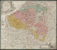
Subject (Geographic):
Cologne (Electorate)--Maps--Early works to 1800., Jülich-Berg--Maps--Early works to 1800., and North Rhine-Westphalia (Germany)--Maps--Early works to 1800.
Subject (Name):
Catholic Church.--Archdiocese of Cologne (Germany)--Maps--Early works to 1800
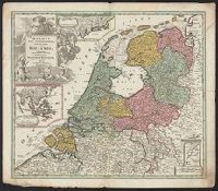
Imperfect: Split into 2 pieces. Mounted on board. Sheet measures 51.3 x 59.7 cm. and Three insets: 1) at top. Batavorum coloniae occidental indiis septentrionalis Americae implantatae. With view of New Amsterdam. 2) at left. India orientalis Batavoru
Publisher:
[Johann Baptist Homann,
Subject (Geographic):
Netherlands--Maps--Early works to 1800 and New York (State)--Maps
Sheet measures 53.4 x 61.4 cm. Ms. note on verso: No. 9, Holland. and Three insets: 1) at top. Batavorum coloniae occidental indiis septentrionalis Americae implantatae. With view of New Amsterdam. 2) at left. India orientalis Batavorum commerciis,
Publisher:
[Johann Baptist Homann,
Subject (Geographic):
Netherlands--Maps--Early works to 1800 and New York (State)--Maps
Bar scales given in "mill. Germanica," "mill. Gallica," and "mill. Italica.", Imperfect: torn along bottom fold, with no loss of text. Watermark. Manuscript number in right corner. From the Karpinski-von Wieser Map Collection., Includes illustration "Die Vestung Kofel.", Relief shown pictorially., and With privilege statement, "Cum privilegio Sac. Cas. Maj." at bottom of cartouche.