Skip to search
Skip to main content
Skip to first result
Search
You Searched For
Language
Latin
Creator
Homann, Johann Baptist, 1663-1724
New Search
Search Results
Creator:
Published / Created:
1720?]
Call Number:
33 1700
Container / Volume:
BRBL_00077
Image Count:
1
Resource Type:
Maps, Atlases & Globes
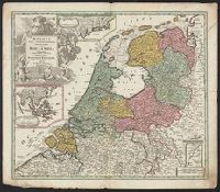
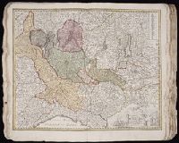
Description:
Imperfect: Split into 2 pieces. Mounted on board. Sheet measures 51.3 x 59.7 cm. and Three insets: 1) at top. Batavorum coloniae occidental indiis septentrionalis Americae implantatae. With view of New Amsterdam. 2) at left. India orientalis Batavoru
Publisher:
[Johann Baptist Homann,
Subject (Geographic):
Netherlands--Maps--Early works to 1800 and New York (State)--Maps
Found in:
Beinecke Rare Book and Manuscript Library > Belgii pars septentrionalis communi nomine vulgo Hollandia nuncupata continens statum potentissimae Batavorum Reipublicea sev provincias VII foederatas / exhibente Io. Baptista Homanno.
Creator:
Published / Created:
1720?]
Call Number:
331 1720
Container / Volume:
BRBL_00078
Image Count:
1
Resource Type:
Maps, Atlases & Globes
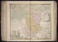
Description:
Sheet measures 53.4 x 61.4 cm. Ms. note on verso: No. 9, Holland. and Three insets: 1) at top. Batavorum coloniae occidental indiis septentrionalis Americae implantatae. With view of New Amsterdam. 2) at left. India orientalis Batavorum commerciis,
Publisher:
[Johann Baptist Homann,
Subject (Geographic):
Netherlands--Maps--Early works to 1800 and New York (State)--Maps
Found in:
Beinecke Rare Book and Manuscript Library > Belgii pars septentrionalis communi nomine vulgo Hollandia nuncupata continens statum potentissimae Batavorum Reipublicea sev provincias VII foederatas / exhibente Io. Baptista Homanno.
Creator:
Published / Created:
1743
Call Number:
1975 Folio 31
Collection Title:
[Atlas factice of 42 maps, produced by the Homann Erben firm]
Image Count:
1
Alternative Title:
Staat von der Republic Genova, nach seiner Eintheilung in die ost- u. west-Revier
Publisher:
Homann Erben
Subject (Geographic):
Genoa (Italy) --Maps --Early works to 1800
Subject (Topic):
Atlases, German --Early works to 1800
Collection Created:
[Nuremberg,
Found in:
Beinecke Rare Book and Manuscript Library > Carta Geographica, la quale rappresenta lo Stato della Republica di Genova partita nella Riviera di Levante et di Ponente / [cartographic material] / data in publico per gli Heredi d'Homann ; con privil. imp le 1743 = Staat von der Republic Genova, nach s
Creator:
Published / Created:
1715?
Call Number:
1973 Folio 30
Collection Title:
[Atlas factice of 32 maps and 1 distance table, produced by the Homann Erben firm]
Image Count:
2
Publisher:
[Johann Baptist Homann]
Subject (Geographic):
Saxony (Germany) --Maps --Early works to 1800
Subject (Topic):
Atlases, German --Early works to 1800
Collection Created:
[Nuremberg : s.n., 1701-1760]
Found in:
Beinecke Rare Book and Manuscript Library > Circulus Saxoniae inferioris in omnes suos status et principatus / [cartographic material] / accurate divisus ex conatibus Io. Bapt. Homanni
Creator:
Published / Created:
[before 1724?]
Call Number:
BrSides Double Folio 2019 42
Image Count:
1
Resource Type:
Maps, Atlases & Globes
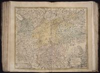
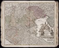
Description:
Bar scales given in "mill. Germanica," "mill. Gallica," and "mill. Italica.", Imperfect: torn along bottom fold, with no loss of text. Watermark. Manuscript number in right corner. From the Karpinski-von Wieser Map Collection., Includes illustration "Die Vestung Kofel.", Relief shown pictorially., and With privilege statement, "Cum privilegio Sac. Cas. Maj." at bottom of cartouche.
Publisher:
[Johann Baptist Homann],
Subject (Geographic):
Tyrol (Austria)--Maps--Early works to 1800.
Found in:
Beinecke Rare Book and Manuscript Library > Comitatus principalis Tirolis : in quo Episc. Tridentin[us] et Brixensis, Comitatus Brigantinus, Feldkirchiae Sonnebergae et Pludentii accuratè exhibentur / editore Ioh. Baptista Homanno, Sacrae Caes. Majestatis Geographo.
Creator:
Published / Created:
[after 1724]
Call Number:
428 1720
Container / Volume:
BRBL_00247
Image Count:
1
Resource Type:
Maps, Atlases & Globes
Description:
Bar scales given in "mill. Germanica," "mill. Gallica," and "mill. Italica.", Includes illustration "Die Vestung Kofel.", Ms. no. on verso: LII. Sheet measures 53 x 65.4 cm., and Relief shown pictorially.
Publisher:
[Johann Baptist Homann],
Subject (Geographic):
Tyrol (Austria)--Maps--Early works to 1800
Found in:
Beinecke Rare Book and Manuscript Library > Comitatus principalis Tirolis : in quo Episc. Tridentin[us] et Brixensis, Comitatus Brigantinus, Feldkirchiae Sonnebergae et Pludentii accuratè exhibentur / editore Ioh. Baptista Homanno, Sacrae Caes. Majestatis Geographo.
Creator:
Published / Created:
[after 1724]
Call Number:
1983 Folio 23
Collection Title:
[Atlas factice of 50 maps, primarily by Johann Baptist Homann and/or issued by the Homann Erben
Image Count:
1
Description:
Bar scales given in "mill. Germanica," "mill. Gallica," and "mill. Italica.", Includes illustration "Die Vestung Kofel.", Relief shown pictorially., and Sheet measures 54.3 x 64.5 cm. No. 30 of 50 maps bound together.
Publisher:
[Johann Baptist Homann],
Subject (Geographic):
Tyrol (Austria)--Maps--Early works to 1800.
Collection Created:
[Nuremberg]
Found in:
Beinecke Rare Book and Manuscript Library > Comitatus principalis Tirolis : in quo Episc. Tridentin[us] et Brixensis, Comitatus Brigantinus, Feldkirchiae Sonnebergae et Pludentii accuratè exhibentur / editore Ioh. Baptista Homanno, Sacrae Caes. Majestatis Geographo.
Creator:
Published / Created:
1720?
Call Number:
1975 Folio 31
Collection Title:
[Atlas factice of 42 maps, produced by the Homann Erben firm]
Image Count:
1
Publisher:
Johann Baptist Homann
Subject (Geographic):
Italy, Northern --Maps --Early works to 1800 and Veneto (Italy) --Maps --Early works to 1800
Subject (Topic):
Atlases, German --Early works to 1800
Collection Created:
[Nuremberg,
Found in:
Beinecke Rare Book and Manuscript Library > Dominii Veneti cum vicinis Parmae, Mutinae, Mantuae, et Mirandolae statibus nova descriptio / [cartographic material] / edita a Ioh. Baptista Homanno, sacrae caes. majestatis geographo
Creator:
Published / Created:
1730?
Call Number:
1975 Folio 31
Collection Title:
[Atlas factice of 42 maps, produced by the Homann Erben firm]
Image Count:
1
Publisher:
Homann
Subject (Geographic):
Milan (Italy : Province) --Maps --Early works to 1800
Subject (Topic):
Atlases, German --Early works to 1800
Collection Created:
[Nuremberg,
Found in:
Beinecke Rare Book and Manuscript Library > Ducatus Mediolani una cum confinyes accurata tabula / [cartographic material] / exhibitus auctus et eme[n]datus per Ioh. Bapt. Homannum
Creator:
Published / Created:
[ca. 1710]
Call Number:
1983 Folio 23
Collection Title:
[Atlas factice of 50 maps, primarily by Johann Baptist Homann and/or issued by the Homann Erben
Image Count:
1
Publisher:
[Johann Baptist Homann]
Subject (Geographic):
Graz (Austria) --Maps, Pictorial --Early works to 1800 and Styria (Austria) --Maps --Early works to 1800
Collection Created:
[Nuremberg : Homann Erben, 1710-1786]
Found in:
Beinecke Rare Book and Manuscript Library > Ducatus Stiriae novissima tabula [cartographic material] / ex ampliore mappa olim R. Dni. Georgii Matth. Vischer S.C.M., Leopoldi I. Glorssae. Memae. Geographi deducta ; et in hac utiliore forma curiosorum oculis exhibita a Ioh. Bapti. Homanno
Branch:v1.61.6 ,Deployed:2024-06-12T09:55:36-04:00