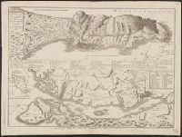
"86" in upper right corner., Appears in Le Rouge's Atlas nouveau portatif à l'usage des militaires (1748 and 1756 eds.)., Bar scale in "milles Angloises, 60 au degré.", Cross Collection no. 296., Hand col., and Relief shown pictorially.
Publisher:
Ches les Sr. le Rouge,
Subject (Geographic):
Antigua--Maps--Early works to 1800
Subject (Name):
Le Rouge, Georges-Louis. Atlas nouveau portatif à l'usage des militaires
"Avec Privilege du Roi.", Insets: Map of territory west of Lake Superior; map of territory west of Florida; view of "Sault du Niagara, de 135 pieds de haut"., Relief shown pictorially., Second state: contains two keys to colors "Couleur selon les pretentions des Anglois" and "Selon les pretentions de la France.", and Watermark. Manuscript number on verso: XV 256.
Publisher:
[Georges-Louis Le Rouge] Rue des Augustins,
Subject (Geographic):
Atlantic States--Maps--Early works to 1800., France--Colonies--America--Maps--Early works to 1800., Great Britain--Colonies--America--Maps--Early works to 1800., Maritime Provinces--Maps--Early works to 1800., and United States--History--French and Indian War, 1754-1763--Maps--Early works to 1800.
"Avec Privilege du Roi.", Insets: Map of territory west of Lake Superior; map of territory west of Florida; view of "Sault du Niagara, de 135 pieds de haut"., Relief shown pictorially., and Second state: contains two keys to colors "Couleur selon les pretentions des Anglois" and "Selon les pretentions de la France."
Publisher:
[Georges-Louis Le Rouge] Rue des Augustins,
Subject (Geographic):
Atlantic States--Maps--Early works to 1800., France--Colonies--America--Maps--Early works to 1800., Great Britain--Colonies--America--Maps--Early works to 1800., Maritime Provinces--Maps--Early works to 1800., and United States--History--French and Indian War, 1754-1763--Maps--Early works to 1800.
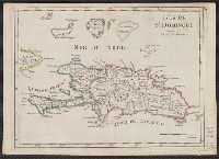
Barbade, une des Antilles aux Anglois divisee par Paroisses.
Description:
"88" in upper left corner., Appears in Le Rouge's Atlas nouveau portatif à l'usage des militaires (1748 and 1756 eds.)., Bar scales given in "milles Angloises" and "milles d'Angleterre Oistins.", Hand col. Sheet mea, and Relief shown pictorially and by hachures.
Publisher:
Par le Sr. le Rouge rue des grands Augustins,
Subject (Geographic):
Saint Kitts--Maps--Early works to 1800
Subject (Name):
Le Rouge, Georges-Louis. Atlas nouveau portatif à l'usage des militaires
Has watermarks., Includes text, chart showing geographical, linguistic, and religious divisions, and decorative cartouche., Prime meridian: Ferro., and Relief shown pictorially.
Includes text., Mounted on cardstock. Neat line measures 49.2 x 64.2 on sheet 53.2, Prime meridian: Ferro., Relief shown pictorially., and Title listed in Le Rouge's Atlas général contenant le detail des quatres parties du monde ... 1741-62. Cf. Phillips, 5975.
Publisher:
Par le Sr. Le Rouge ing., géographe du roy, rue des Grs. Augustines,
Subject (Geographic):
America--Maps--Early works to 1800
Subject (Name):
Charlevoix, Pierre-François-Xavier de, 1682-1761, La Condamine, Charles-Marie de, 1701-1774, and Le Rouge, Georges-Louis. Atlas général