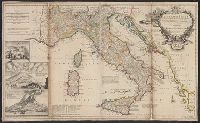
"Note: the post roads in this map are taken from Iacobo Cantelli da Vignola the Duke of Modena's geographer.", *40 1714: verso: stamped "Yale UL"; dgvmp2008., and Includes inset views of Caesium, Vesuvius, Aetna.
Publisher:
printed for H. Moll...Ino. Bowles...T. Bowles...Philip Overton,
Subject (Geographic):
Italy--Maps--Early works to 1800 and Mediterranean Region--Maps--Early works to 1800
Subject (Name):
Bowles, John, 1701-1779, Bowles, Thomas, -1767, Cantelli da Vignola, Giacomo, 1643-1719, and Overton, Philip, -1751
Carte de l'Italie et de touts ses routes de poste, à l'usage de voyageurs
Description:
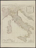
Appears in Laurie and Whittle, A new universal atlas, 1796, plate 16., Horizontal fold at middle of map and guard on verso., Includ, Relief shown pictorially., and Sheet measures 72 x 54 cm. Stamp on verso: Karpinski-von Wieser Map Collection. dgvmp2008.
Publisher:
Laurie & Whittle,
Subject (Geographic):
Italy--Maps--Early works to 1800
Subject (Name):
Anville, Jean Baptiste Bourguignon d', 1697-1782 and Robert Laurie and James Whittle
"Gift of Philip A. Means"--Verso. and Relief shown pictorially.
Subject (Geographic):
Germany, Southern--Maps, Illyria (Kingdom)--Maps, and Italy--Maps
Subject (Name):
Means, Philip Ainsworth,--1892-1944--Ownership
Subject (Topic):
Post office stations and branches--Germany, Southern--Maps, Post office stations and branches--Italy--Maps, Post roads--Germany, Southern--Maps, and Post roads--Italy--Maps
BEIN 2003 Folio 85: No. 31 of 45 maps bound together with binder's spine title: Atlas of America; ms. table of contents. Bookplate: Robinson. Bookplate of Paul Mellon., Hand colored., Includes inset A general plan of Port Royal, in which the different states of the town are accurately laid down, ca. 1:3,200., Relief shown pictorially. Soundings shown in fathoms., Scale [ca. 1:420,000]., and the greatest part drawn or corrected from actual surveys made by Mr. Sheffield and others.
Publisher:
Printed for John Bowles ... and Carington Bowles
Subject (Geographic):
Jamaica -- Maps -- Early works to 1800 and Port Royal (Jamaica) -- Maps -- Early works to 1800
"Entered according to act of Congress in the year 1859 by C. Desilver in the clerk's office of the district court of the Eastern District of Pennsylvania." and Relief shown by hachures.
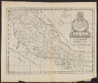
"Dedicated to His Highness William Duke of Glocester.", Appears in E. Wells' A new sett of maps both of antient and present geography., English, with Latin place names., Includes ornamental cartouche., Relief shown pictorially., and Watermarks: RDS, and fleur-de-l
Publisher:
s.n.,
Subject (Geographic):
Italy--Historical geography--Maps--Early works to 1800, Italy--History--To 476--Maps--Early works to 1800, and Rome--Maps--Early works to 1800
Subject (Name):
Nicholls, Sutton and Wells, Edward, 1667-1727. New sett of maps both of antient and present geography
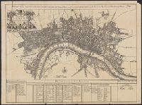
A plan of the City's of London, Westminster and Borough of Southwark; with the new Additional Buildings Anno. 1720., E. Weller, litho. London, Cassel & Co., [1910?], and Index to names on map in margin.