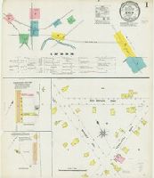
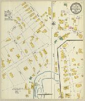
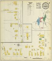
Sanborn fire insurance maps are a rich source of historic data on the urban built environment of North America during the 19th and early 20th centuries. The atlases were created for the purpose of underwriting fire insurance policies, which depended upon accurate and frequently-updated information about construction materials, municipal and transportation infrastructure, industrial and commercial landuse and more. The Yale University Library Map Department scanned its holdings of Sanborn fire insurance maps (consisting primarily of Connecticut towns) in order to make the maps more accessible.
Alternative Title:
April 1908, Berlin, Conn. and Berlin, Conn.
Description:
"8 sheets, #217.", Contains information on population, prevailing winds, water facilities and fire department., Includes index of streets and specials., Partial cadastral map., and SMLMAPL 766 B45 1908: Sheets disbound. "Triplicate" stamp on all sheets. Library of Congress copyright stamp on title sheet.
Subject (Geographic):
Berlin (Conn.)--Maps
Subject (Name):
Library of Congress Stamp
Subject (Topic):
Fire risk assessment--Connecticut--Berlin--Maps and Real property--Connecticut--Berlin--Maps
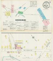
Sanborn fire insurance maps are a rich source of historic data on the urban built environment of North America during the 19th and early 20th centuries. The atlases were created for the purpose of underwriting fire insurance policies, which depended upon accurate and frequently-updated information about construction materials, municipal and transportation infrastructure, industrial and commercial landuse and more. The Yale University Library Map Department scanned its holdings of Sanborn fire insurance maps (consisting primarily of Connecticut towns) in order to make the maps more accessible.
Alternative Title:
Apr. 1914, Berlin, Conn. and Berlin, Conn.
Description:
"6794 (9 sheets).", Contains information on population, prevailing winds, water facilities and fire department., Includes index of streets and specials., Partial cadastral map., and SMLMAPL 766 B45 1914: Imperfect: sheet 1 torn, with no loss of text. Sheets disbound. "Triplicate" stamp on all sheets. Library of Congress copyright stamp on title sheet.
Subject (Geographic):
Berlin (Conn.)--Maps
Subject (Name):
Library of Congress Stamp
Subject (Topic):
Fire risk assessment--Connecticut--Berlin--Maps and Real property--Connecticut--Berlin--Maps
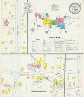
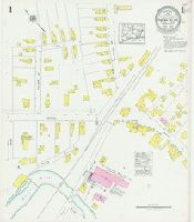
Sanborn fire insurance maps are a rich source of historic data on the urban built environment of North America during the 19th and early 20th centuries. The atlases were created for the purpose of underwriting fire insurance policies, which depended upon accurate and frequently-updated information about construction materials, municipal and transportation infrastructure, industrial and commercial landuse and more. The Yale University Library Map Department scanned its holdings of Sanborn fire insurance maps (consisting primarily of Connecticut towns) in order to make the maps more accessible.
Alternative Title:
Bethel, Conn. and May 1906, Bethel, Conn.
Description:
"5 sheets 8786.", Contains information on population, prevailing winds, water facilities and fire department., Includes index of streets and specials., Partial cadastral map., and SMLMAPL 766 B467 1906: Sheets disbound. "Triplicate" stamp on all sheets. Library of Congress copyright stamp on title sheet.
Subject (Geographic):
Bethel (Conn.)--Maps
Subject (Name):
Library of Congress Stamp
Subject (Topic):
Fire risk assessment--Connecticut--Berlin--Maps and Real property--Connecticut--Bethel--Maps
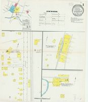
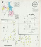
Sanborn fire insurance maps are a rich source of historic data on the urban built environment of North America during the 19th and early 20th centuries. The atlases were created for the purpose of underwriting fire insurance policies, which depended upon accurate and frequently-updated information about construction materials, municipal and transportation infrastructure, industrial and commercial landuse and more. The Yale University Library Map Department scanned its holdings of Sanborn fire insurance maps (consisting primarily of Connecticut towns) in order to make the maps more accessible.
Alternative Title:
May 1909, Canaan, Conn.
Description:
"1436, 3 sheets.", Contains information on population, prevailing winds, water facilities and fire department., Includes index to specials., Partial cadastral map., and SMLMAPL 766 C16 1909: Sheets disbound. Library of Congress copyright stamp on title sheet.
Subject (Geographic):
Canaan (Conn.)--Maps
Subject (Name):
Library of Congress Stamp
Subject (Topic):
Fire risk assessment--Connecticut--Canaan--Maps and Real property--Connecticut--Canaan--Maps
Sanborn fire insurance maps are a rich source of historic data on the urban built environment of North America during the 19th and early 20th centuries. The atlases were created for the purpose of underwriting fire insurance policies, which depended upon accurate and frequently-updated information about construction materials, municipal and transportation infrastructure, industrial and commercial landuse and more. The Yale University Library Map Department scanned its holdings of Sanborn fire insurance maps (consisting primarily of Connecticut towns) in order to make the maps more accessible.
Description:
"(6399).", Contains information on population, prevailing winds, water facilities and fire department., Partial cadastral map., and SMLMAPL 766 C33 1903: "Triplicate" stamp and Library of Congress copyright and Map Division stamps on title sheet.
Subject (Geographic):
Plainfield (Conn.)--Maps
Subject (Name):
Library of Congress Stamp and Library of Congress. Map Division Stamp
Subject (Topic):
Fire risk assessment--Connecticut--Plainfield--Maps and Real property--Connecticut--Plainfield--Maps
Sanborn fire insurance maps are a rich source of historic data on the urban built environment of North America during the 19th and early 20th centuries. The atlases were created for the purpose of underwriting fire insurance policies, which depended upon accurate and frequently-updated information about construction materials, municipal and transportation infrastructure, industrial and commercial landuse and more. The Yale University Library Map Department scanned its holdings of Sanborn fire insurance maps (consisting primarily of Connecticut towns) in order to make the maps more accessible.
Alternative Title:
June 1927, Central Village, Conn.
Description:
"(3170) (2 sheets).", Contains information on population, prevailing winds, water facilities and fire department., Includes index to streets and specials., Partial cadastral map., and SMLMAPL 766 C33 1927: Sheets disbound. Library of Congress copyright stamp on title sheet.
Subject (Geographic):
Plainfield (Conn.)--Maps
Subject (Name):
Library of Congress Stamp
Subject (Topic):
Fire risk assessment--Connecticut--Plainfield--Maps and Real property--Connecticut--Plainfield--Maps
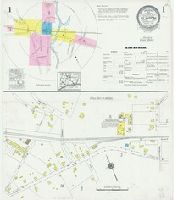
Sanborn fire insurance maps are a rich source of historic data on the urban built environment of North America during the 19th and early 20th centuries. The atlases were created for the purpose of underwriting fire insurance policies, which depended upon accurate and frequently-updated information about construction materials, municipal and transportation infrastructure, industrial and commercial landuse and more. The Yale University Library Map Department scanned its holdings of Sanborn fire insurance maps (consisting primarily of Connecticut towns) in order to make the maps more accessible.
Alternative Title:
Jan. 1925, Cheshire, Conn.
Description:
"(2002) (6 sheets).", Contains information on population, prevailing winds, water facilities and fire department., Includes index to streets and specials., Partial cadastral map., Sheets 2 and 3 at scale 1:600; sheets 1, 4, 5 and 6 at scale 1:1,200., and SMLMAPL 766 C422 1925: Sheets disbound. Library of Congress copyright stamp on title sheet.
Subject (Geographic):
Cheshire (Conn.)--Maps
Subject (Name):
Library of Congress Stamp
Subject (Topic):
Fire risk assessment--Connecticut--Cheshire--Maps and Real property--Connecticut--Cheshire--Maps
Sanborn fire insurance maps are a rich source of historic data on the urban built environment of North America during the 19th and early 20th centuries. The atlases were created for the purpose of underwriting fire insurance policies, which depended upon accurate and frequently-updated information about construction materials, municipal and transportation infrastructure, industrial and commercial landuse and more. The Yale University Library Map Department scanned its holdings of Sanborn fire insurance maps (consisting primarily of Connecticut towns) in order to make the maps more accessible.
Alternative Title:
Feb. 1908, Clinton, Conn.
Description:
"4 sheets, 83.", Contains information on population, prevailing winds, water facilities and fire department., Includes index of specials., Partial cadastral map., and SMLMAPL 766 C61 1908: Sheets disbound. "Triplicate" stamp on all sheets. Library of Congress and Map Division stamps on title sheet.
Subject (Geographic):
Clinton (Conn.)--Maps
Subject (Name):
Library of Congress Stamp and Library of Congress. Map Division Stamp
Subject (Topic):
Fire risk assessment--Connecticut--Clinton--Maps and Real property--Connecticut--Clinton--Maps
Sanborn fire insurance maps are a rich source of historic data on the urban built environment of North America during the 19th and early 20th centuries. The atlases were created for the purpose of underwriting fire insurance policies, which depended upon accurate and frequently-updated information about construction materials, municipal and transportation infrastructure, industrial and commercial landuse and more. The Yale University Library Map Department scanned its holdings of Sanborn fire insurance maps (consisting primarily of Connecticut towns) in order to make the maps more accessible.
Alternative Title:
Jan. 1924, Clinton, Conn.
Description:
"(1439) (6 sheets).", Contains information on population, prevailing winds, water facilities and fire department., Includes index of streets and specials., Partial cadastral map., Sheets 2 and 4 at scale 1:600; sheets 1, 3, 5 and 6 at scale 1:1,200., and SMLMAPL 766 C61 1924: Sheets disbound. Library of Congress copyright stamp on title sheet.
Subject (Geographic):
Clinton (Conn.)--Maps
Subject (Name):
Library of Congress Stamp
Subject (Topic):
Fire risk assessment--Connecticut--Clinton--Maps and Real property--Connecticut--Clinton--Maps
Sanborn fire insurance maps are a rich source of historic data on the urban built environment of North America during the 19th and early 20th centuries. The atlases were created for the purpose of underwriting fire insurance policies, which depended upon accurate and frequently-updated information about construction materials, municipal and transportation infrastructure, industrial and commercial landuse and more. The Yale University Library Map Department scanned its holdings of Sanborn fire insurance maps (consisting primarily of Connecticut towns) in order to make the maps more accessible.
Alternative Title:
Sep. 1903, Colchester, Conn.
Description:
"6451. 3 sheets.", Contains information on population, prevailing winds, water facilities and fire department., Includes index of specials., Partial cadastral map., and SMLMAPL 766 C67 1903: Sheets disbound. "Triplicate" stamp on all sheets. Library of Congress copyright stamp on title sheet.
Subject (Geographic):
Colchester (Conn.)--Maps
Subject (Name):
Library of Congress Stamp
Subject (Topic):
Fire risk assessment--Connecticut--Colchester--Maps and Real property--Connecticut--Colchester--Maps