Covers area from Greeley and Hall counties on the west to Sioux City and Omaha on the east, Antelope and Dakota counties on the north and Hall County and city of Lincoln on the south., Label on upper left covering original title and legend: O.F. Davis, (late Land Commissioner U.P.R.R.), Webster Snyder, Nebraska Land Agency, Davis & Snyder, 1505 Farnam St., Omaha, Neb., general dealers in real estate ... Omaha, May 15th, 1880., Shows railroads, drainage, and township and range grid., and Title taken from original text covered by label in upper left.
Overland journey across the Plains to Oregon /by William H. Frush, 1850-1852
Image Count:
4
Abstract:
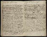
In 1850 Frush traveled from Missouri to Oregon by way of St. Joseph, Blue River, the North Platte, and Fort Laramie, where he met his brother John and Kit Carson. They continued by South Pass, Bear River, Soda Springs, Fort Hall, Fort Boise, the Dalles, and Portland. He records graves, the names and homes of other travelers, and ends his account with events in Oregon. The diary contains drawings of Chimney Rock, Court House Rock, profile of the Snake River, and a map of the Burnt River.
Subject (Geographic):
Oregon --Baker County --Maps, West (U.S.) --Description and travel, and West (U.S.) --Maps