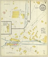
Sanborn fire insurance maps are a rich source of historic data on the urban built environment of North America during the 19th and early 20th centuries. The atlases were created for the purpose of underwriting fire insurance policies, which depended upon accurate and frequently-updated information about construction materials, municipal and transportation infrastructure, industrial and commercial landuse and more. The Yale University Library Map Department scanned its holdings of Sanborn fire insurance maps (consisting primarily of Connecticut towns) in order to make the maps more accessible.
Alternative Title:
Sept. 1923, Lakeville, Conn.
Description:
"(1229) (5 sheets).", Contains information on population, prevailing winds, water facilities and fire department., Includes index of streets and specials., Partial cadastral map., Sheets 2-4 at scale 1:600 ; sheets 1 and 5 at scale 1:1,200., and SMLMAPL 766 L14 1923: Sheets disbound. Library of Congress copyright stamp on title sheet.
Subject (Geographic):
Lakeville (Conn.)--Maps
Subject (Name):
Library of Congress Stamp
Subject (Topic):
Fire risk assessment--Connecticut--Lakeville--Maps and Real property--Connecticut--Lakeville--Maps
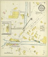
Sanborn fire insurance maps are a rich source of historic data on the urban built environment of North America during the 19th and early 20th centuries. The atlases were created for the purpose of underwriting fire insurance policies, which depended upon accurate and frequently-updated information about construction materials, municipal and transportation infrastructure, industrial and commercial landuse and more. The Yale University Library Map Department scanned its holdings of Sanborn fire insurance maps (consisting primarily of Connecticut towns) in order to make the maps more accessible.
Alternative Title:
Jan. 1904, Lime Rock, Conn.
Description:
"6695. 2 sheets.", Contains information on population, prevailing winds, water facilities and fire department., Partial cadastral map., and SMLMAPL 766 L62 1904: Sheets disbound. "Triplicate" stamp on both sheets. Library of Congress copyright stamp on title sheet.
Subject (Geographic):
Salisbury (Conn.)--Maps
Subject (Name):
Library of Congress Stamp
Subject (Topic):
Fire risk assessment--Connecticut--Salisbury--Maps and Real property--Connecticut--Salisbury--Maps
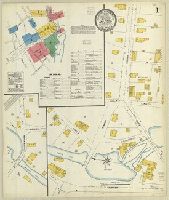
Sanborn fire insurance maps are a rich source of historic data on the urban built environment of North America during the 19th and early 20th centuries. The atlases were created for the purpose of underwriting fire insurance policies, which depended upon accurate and frequently-updated information about construction materials, municipal and transportation infrastructure, industrial and commercial landuse and more. The Yale University Library Map Department scanned its holdings of Sanborn fire insurance maps (consisting primarily of Connecticut towns) in order to make the maps more accessible.
Alternative Title:
May 1909, Lime Rock, Conn.
Description:
"1439. (2 sheets).", Contains information on population, prevailing winds, water facilities and fire department., Partial cadastral map., and SMLMAPL 766 L62 1909: Sheets disbound. Library of Congress copyright stamp on title sheet.
Subject (Geographic):
Salisbury (Conn.)--Maps
Subject (Name):
Library of Congress Stamp
Subject (Topic):
Fire risk assessment--Connecticut--Salisbury--Maps and Real property--Connecticut--Salisbury--Maps
Sanborn fire insurance maps are a rich source of historic data on the urban built environment of North America during the 19th and early 20th centuries. The atlases were created for the purpose of underwriting fire insurance policies, which depended upon accurate and frequently-updated information about construction materials, municipal and transportation infrastructure, industrial and commercial landuse and more. The Yale University Library Map Department scanned its holdings of Sanborn fire insurance maps (consisting primarily of Connecticut towns) in order to make the maps more accessible.
Alternative Title:
Lime Rock, Conn., June 1931.
Description:
"(2 sheets).", Contains information on population, prevailing winds, water facilities and fire department., Partial cadastral map., and SMLMAPL 766 L62 1931: Sheets disbound. Library of Congress copyright stamp on title sheet.
Subject (Geographic):
Salisbury (Conn.)--Maps
Subject (Name):
Library of Congress Stamp
Subject (Topic):
Fire risk assessment--Connecticut--Salisbury--Maps and Real property--Connecticut--Salisbury--Maps
Sanborn fire insurance maps are a rich source of historic data on the urban built environment of North America during the 19th and early 20th centuries. The atlases were created for the purpose of underwriting fire insurance policies, which depended upon accurate and frequently-updated information about construction materials, municipal and transportation infrastructure, industrial and commercial landuse and more. The Yale University Library Map Department scanned its holdings of Sanborn fire insurance maps (consisting primarily of Connecticut towns) in order to make the maps more accessible.
Alternative Title:
Oct. 1923, Litchfield, Conn.
Description:
"(1303). (8 sheets).", "Including Bantam.", Contains information on population, prevailing winds, water facilities and fire department., Includes index of specials., Partial cadastral map., Sheets 2-3 and 7-8 at scale 1:600 ; sheets 1, 4-6 at scale 1:1,200., and SMLMAPL 766 L71 1923: Sheets disbound. Library of Congress copyright stamp on title sheet.
Subject (Geographic):
Litchfield (Conn.)--Maps
Subject (Name):
Library of Congress Stamp
Subject (Topic):
Fire risk assessment--Connecticut--Litchfield--Maps and Real property--Connecticut--Litchfield--Maps
Sanborn fire insurance maps are a rich source of historic data on the urban built environment of North America during the 19th and early 20th centuries. The atlases were created for the purpose of underwriting fire insurance policies, which depended upon accurate and frequently-updated information about construction materials, municipal and transportation infrastructure, industrial and commercial landuse and more. The Yale University Library Map Department scanned its holdings of Sanborn fire insurance maps (consisting primarily of Connecticut towns) in order to make the maps more accessible.
Alternative Title:
Apr. 1910, Litchfield, Conn.
Description:
"2250. (4 sheets).", Contains information on population, prevailing winds, water facilities and fire department., Includes index of specials., Partial cadastral map., Sheets 1-2 at scale 1:600 ; sheets 3-4 at scale 1:1,200., and SMLMAPL 766 L71 1910: Sheets disbound. Library of Congress copyright stamp on title sheet.
Subject (Geographic):
Litchfield (Conn.)--Maps
Subject (Name):
Library of Congress Stamp
Subject (Topic):
Fire risk assessment--Connecticut--Litchfield--Maps and Real property--Connecticut--Litchfield--Maps
Sanborn fire insurance maps are a rich source of historic data on the urban built environment of North America during the 19th and early 20th centuries. The atlases were created for the purpose of underwriting fire insurance policies, which depended upon accurate and frequently-updated information about construction materials, municipal and transportation infrastructure, industrial and commercial landuse and more. The Yale University Library Map Department scanned its holdings of Sanborn fire insurance maps (consisting primarily of Connecticut towns) in order to make the maps more accessible.
Alternative Title:
July 1915, Madison, Conn.
Description:
"700. (5 sheets).", Contains information on population, prevailing winds, water facilities and fire department., Includes index of streets and specials., Partial cadastral map., Sheets 1-3 at scale 1:600 ; sheets 4-5 at scale 1:1,200., and SMLMAPL 766 M26 1915: Sheets disbound. Library of Congress copyright stamp on title sheet.
Subject (Geographic):
Madison (Conn.)--Maps
Subject (Name):
Library of Congress Stamp
Subject (Topic):
Fire risk assessment--Connecticut--Madison--Maps and Real property--Connecticut--Madison--Maps
Sanborn fire insurance maps are a rich source of historic data on the urban built environment of North America during the 19th and early 20th centuries. The atlases were created for the purpose of underwriting fire insurance policies, which depended upon accurate and frequently-updated information about construction materials, municipal and transportation infrastructure, industrial and commercial landuse and more. The Yale University Library Map Department scanned its holdings of Sanborn fire insurance maps (consisting primarily of Connecticut towns) in order to make the maps more accessible.
Alternative Title:
Apr. 1925, Madison, Conn.
Description:
"(2186) 6 sheets.", "Including East River, Highland Point, Hartford Beach, Circle Beach, Webster Point, Bayberry Farm, Seaview Farm, Middle Beach, East Wharf & West Wharf.", Contains information on population, prevailing winds, water facilities and fire department., Includes index of streets and specials., Partial cadastral map., Sheet 1 at scale 1:600 ; sheets 2-6 at scale 1:1,200., and SMLMAPL 766 M26 1925: Sheets disbound. Library of Congress copyright stamp on title sheet.
Subject (Geographic):
Madison (Conn.)--Maps
Subject (Name):
Library of Congress Stamp
Subject (Topic):
Fire risk assessment--Connecticut--Madison--Maps and Real property--Connecticut--Madison--Maps
Sanborn fire insurance maps are a rich source of historic data on the urban built environment of North America during the 19th and early 20th centuries. The atlases were created for the purpose of underwriting fire insurance policies, which depended upon accurate and frequently-updated information about construction materials, municipal and transportation infrastructure, industrial and commercial landuse and more. The Yale University Library Map Department scanned its holdings of Sanborn fire insurance maps (consisting primarily of Connecticut towns) in order to make the maps more accessible.
Alternative Title:
Jan. 1906, Milford, Conn.
Description:
"13 sheets. 8550.", Contains information on population, prevailing winds, water facilities and fire department., Includes index of streets and specials., Partial cadastral map., SMLMAPL 766 M59 1906: Sheets disbound. "Triplicate" stamp on all sheets. Library of Congress copyright and Map Division stamps on title sheet., and Some sheets include subtitle: "Ft. Trumbull Beach," "Myrtle Beach," "Laurel Beach," "Merwin Beach," or "Woodmont,"
Subject (Geographic):
Milford (Conn.)--Maps
Subject (Name):
Library of Congress Stamp and Library of Congress. Map Division Stamp
Subject (Topic):
Fire risk assessment--Connecticut--Milford--Maps and Real property--Connecticut--Milford--Maps
Sanborn fire insurance maps are a rich source of historic data on the urban built environment of North America during the 19th and early 20th centuries. The atlases were created for the purpose of underwriting fire insurance policies, which depended upon accurate and frequently-updated information about construction materials, municipal and transportation infrastructure, industrial and commercial landuse and more. The Yale University Library Map Department scanned its holdings of Sanborn fire insurance maps (consisting primarily of Connecticut towns) in order to make the maps more accessible.
Alternative Title:
Aug. 1903, Moosup, Conn.
Description:
"2 sheets. 6396.", Contains information on population, prevailing winds, water facilities and fire department., Partial cadastral map., and SMLMAPL 766 M78 1903: Sheets disbound. "Triplicate" stamp on both sheets. Library of Congress copyright stamp on title sheet.
Subject (Geographic):
Moosup (Conn.)--Maps
Subject (Name):
Library of Congress Stamp
Subject (Topic):
Fire risk assessment--Connecticut--Moosup--Maps and Real property--Connecticut--Moosup--Maps