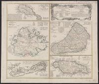
Cross Collection no. 253., Includes explanatory notes and index., Ms. notes in upper right corner., Relief shown pictorially., Scales in millaria Anglica communia and/or millaria Anglica statuta., Sheet title in Latin and German. Individual map titles and text in German. Maps in English and German., and Three maps (Antigua, Barbados, Jamaica). Mounted on linen.
Publisher:
Homann Erben,
Subject (Geographic):
Antigua--Maps--Early works to 1800, Barbados--Maps--Early works to 1800, Bermuda Islands--Maps--Early works to 1800, Jamaica--Maps--Early works to 1800, and Saint Kitts and Nevis--Maps--Early works to 1800
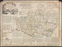
BEIN 2003 Folio 85: No. 37 of 45 maps bound together with binder's spine title: Atlas of America; ms. table of contents. Bookplate: Robinson. Bookplate of Paul Mellon., by Thomas Jefferys, geographer to His Majesty., Hand colored., Inset: Prince Rupert's Bay., Observations, by David Ross; mentions date of 1761., Relief shown pictorially. Depth shown by soundings., and Scale [ca. 1:90,000].
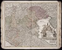
"Cum privilegio Sac. Caes. Majestatis.", Bar scales given in "milliaria Germanica," "milliaria Gallica," and ""milliaria Italica.", Manuscript number in upper right corner: 43. From the Karpinski-von Wieser Map Collection., and Relief shown pictorially.
Publisher:
[Johann Baptist Homann]
Subject (Geographic):
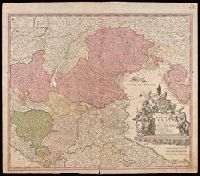
Italy, Northern--Maps--Early works to 1800. and Veneto (Italy)--Maps--Early works to 1800.
Relief shown pictorially., Signature 2B, page number 30 on verso., Stamp: Karpinski-von Wieser Map Collection., Text on verso in Latin., and Verso not digitized.
Includes inset map of Newfoundland, scale 1:3,000,000. and Shows boundaries, hydrological and transportation features, submarine cables, and place names.