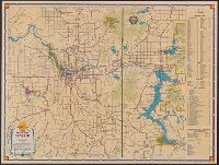
Downtown Spokane., Shell street guide and metropolitan map of Spokane and vicinity, Street guide and metropolitan map of Spokane and vicinity, and Street map of Spokane.
Description:
"469-S" and "10-M 1939-1.", Indexed "Street map of Spokane," "Downtown Spokane" map, text, and ill. on verso., Indexed., and Relief shown by hachures and spot heights.
Publisher:
H.M. Gousha,
Subject (Geographic):
Spokane (Wash.)--Maps and Spokane Metropolitan Area (Wash.)--Maps
Subject (Name):
Shell Union Oil Corporation
Subject (Topic):
Central business districts--Washington (State)--Spokane--Maps, Roads--Washington (State)--Spokane Metropolitan Area--Maps, and Streets--Washington (State)--Spokane--Maps
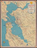
San Francisco and vicinity and Shell metropolitan map, San Francisco and vicinity
Description:
"Copyrighted by the H.M. Goushá Company.", "G-182-S.C.", Index, ill., and "Map of downtown San Francisco, featuring points of interest, parks and principal buildings" on verso., and Relief shown pictorially and by spot heights.
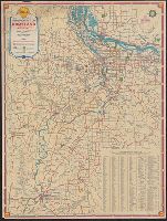
Columbia River highway, Bridal Veil bridge to The Dalles., Downtown Portland., Downtown Salem., Downtown Vancouver., and Shell metropolitan map, Portland and vicinity
Description:
"G-185 S.C.", At head of title: Shell., Ill., and maps of "Downtown Portland," "Downtown Salem," "Downtown Vancouver," and "Columbia River highway: Bridal Veil bridge to The Dalles" (U.S. highway 30) on verso., Indexed., and Relief shown pictorially.
Publisher:
The H.M. Gousha Company,
Subject (Geographic):
Columbia River Gorge (Or. and Wash.)--Maps, Columbia River Highway (Or.)--Maps, Portland (Or.)--Maps, Portland Metropolitan Area (Or.)--Maps, Salem (Or.)--Maps, and Vancouver (Wash.)--Maps
Indexed atlas of the world map of Mexico and Rand, McNally & Co.'s indexed atlas of the world map of Mexico
Description:
Includes "Map of the Valley of Mexico." Scale ca. [1:400,000]., On verso: Plan of the city of Mexico. Scale [ca. 1:16,000] -- Valley of Mexico. Scale [ca. 1:172,000]., Relief shown by hachures and spot heights., and Shows railroads.
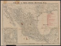
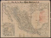
Indexed atlas of the world map of Mexico, Plano general de la ciudad de Mexico., and Rand, McNally & Co.'s indexed atlas of the world map of Mexico
Description:
"Cia. de la Guia Oficial Mexicana S.A.", Includes index to railroads and "Map of the Valley of Mexico, on enlarged scale" (scale [ca. 1:300,000])., On verso: Plano general de la ciudad de Mexico / formado de esprofeso p.a la C.a de la Guia Oficial Mexicana ; Luis G. Becerril. Scale 1:15,000. 1903., and Relief shown by hachures and spot heights.
Publisher:
Rand, McNally,
Subject (Geographic):
Mexico City (Mexico)--Maps and Mexico--Maps
Subject (Name):
Cia. de la Guia Oficial Mexicana S.A
Subject (Topic):
Railroads--Mexico--Maps and Streets--Mexico--Mexico City--Maps
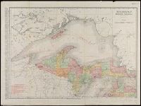
New business atlas map of Michigan., New business atlas map of northern Michigan., Rand, McNally & Co.'s new business atlas map of Michigan., and Rand, McNally & Co.'s new business atlas map of northern Michigan.
Description:
Alternate title: Rand, McNally & Co.'s new business atlas map of Michigan ; Rand, McNally & Co.'s new business atlas map of northern Michigan., Includes indexes of places and railroads., Relief shown by hachures., and Shows railroads, electric lines, and steamship lines.
Publisher:
Rand McNally & Co.,
Subject (Geographic):
Michigan--Maps
Subject (Name):
Rand McNally and Company. Michigan, Northern Peninsula
Ancillary maps on verso: [1.] The far east. Scale [ca. 1:40 900 000] at equator -- [2.] Western hemisphere defense map. Scale [ca. 1:35 000 000]. and Legend and dates of war declarations.
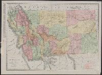
Also shows railroads., Below scale: Rand McNally's new business atlas map of Montana. Copyright 1911 .... Copyright 1909 ...., Indexed., and Relief shown by hachures and spot heights.