Skip to search
Skip to main content
Skip to first result
Search
You Searched For
Access
Public
Genre
Maps
Creator
United States. Office of Strategic Services. Research and Analysis Branch
New Search
Search Results
Creator:
Published / Created:
1944
Call Number:
56cb 1944
Container / Volume:
BRBL_00297
Image Count:
1
Resource Type:
Maps, Atlases & Globes
Alternative Title:
Map ; no. 3218 and Map ; no. 3218.
Description:
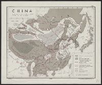
"19 June 1944.", Covers most of East Asia., and Shows landforms, boundaries, and roads.
Publisher:
Reproduction Branch, OSS,
Subject (Geographic):
China--Maps
Subject (Topic):
Boundaries--China--Maps, Boundaries--East Asia--Maps, Landforms--China--Maps, Landforms--East Asia--Maps, Roads--China--Maps, and Roads--East Asia--Maps
Found in:
Beinecke Rare Book and Manuscript Library > China [cartographic material] / drawn in the Branch of Research and Analysis, OSS.
Creator:
Published / Created:
1945
Call Number:
56gme H89 1945
Container / Volume:
BRBL_00299
Image Count:
1
Resource Type:
Maps, Atlases & Globes
Description:
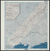
"9 March 1945." and "No. 6184."
Publisher:
Reproduction Branch, OSS,
Subject (Geographic):
China--Maps, Guangxi Zhuangzu Zizhiqu (China)--Maps, and Hunan Sheng (China)--Maps
Subject (Name):
United States. Office of Strategic Services. Reproduction Branch
Subject (Topic):
Railroads--China--Maps
Found in:
Beinecke Rare Book and Manuscript Library > China [cartographic material] : the Hunan-Kwangsi Railroad / R & A, OSS.
Creator:
Published / Created:
[1944]
Call Number:
56eb 1944
Container / Volume:
BRBL_00298
Image Count:
1
Resource Type:
Maps, Atlases & Globes
Description:
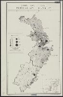
"25 October 1944.", "From the Christian Occupation of China, published by China Continuation Committee, Shanghai, 1922.", "No. A-5443, R&A, OSS.", "Restricted.", DLC, Includes inset with location map., and LC copy stamped on: 212.
Publisher:
Lithographed in the Reproduction Branch, OSS,
Subject (Geographic):
China--Maps
Subject (Name):
United States. Office of Strategic Services. Reproduction Branch
Subject (Topic):
Population density--China--Maps
Found in:
Beinecke Rare Book and Manuscript Library > China, east coast [cartographic material] : population density.
Creator:
Published / Created:
1943
Call Number:
50ba 1943
Container / Volume:
BRBL_00274
Image Count:
1
Resource Type:
Maps, Atlases & Globes
Description:
"28 Dec. 1943.", "Map no. 2870.", and Includes text.
Publisher:
Reproduction Branch, O.S.S.,
Subject (Geographic):
Asia--Distances, etc.--Maps and Pacific Ocean--Distances, etc.--Maps
Subject (Topic):
Azimuthal projection (Cartography)--Maps and Gnomonic projection (Cartography)--Maps
Found in:
Beinecke Rare Book and Manuscript Library > Eastern Asia and western Pacific Ocean, Gnomonic projection / compiled and drawn in the Branch of Research and Analysis, O.S.S.
Creator:
Published / Created:
1943?]
Call Number:
30gme 1943
Container / Volume:
BRBL_00038
Image Count:
1
Resource Type:
Maps, Atlases & Globes
Description:
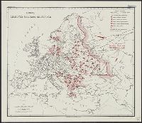
"Map no. 1951 January 9, 1943."
Publisher:
OSS Reproduction Section,
Subject (Geographic):
Europe--Maps
Subject (Topic):
Railroads--Europe--Maps
Found in:
Beinecke Rare Book and Manuscript Library > Europe : selected railroad objectives / compiled and drawn in the Branch of Research and Analysis, OSS.
Creator:
Published / Created:
1943]
Call Number:
38gme 1943
Container / Volume:
BRBL_00171
Image Count:
1
Resource Type:
Maps, Atlases & Globes
Description:
"Map no. 1957, Jan. 9, 1943." and Includes 2 auxiliary maps: Paris and environs; Corsica.
Publisher:
R. and A., OSS,
Subject (Geographic):
France--Maps
Subject (Topic):
Railroads--France--Maps
Found in:
Beinecke Rare Book and Manuscript Library > France railways [cartographic material].
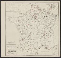
Creator:
Published / Created:
1943
Call Number:
38gme 1943B
Container / Volume:
BRBL_00171
Image Count:
1
Resource Type:
Maps, Atlases & Globes
Description:
"Map no. 2318 (supersedes map no. 641); revised 14 July 1943.", Inset: Paris and environs., and Shows: international boundaries, railways (4 categories).
Publisher:
O.S.S.,
Subject (Geographic):
France--Maps
Subject (Topic):
Railroads--France--Maps
Found in:
Beinecke Rare Book and Manuscript Library > France, national railroads [cartographic material] / compiled and drawn in the Branch of Research and Analysis, OSS.
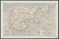
Creator:
Published / Created:
1944
Call Number:
36gm 1944A
Container / Volume:
BRBL_00130
Image Count:
1
Resource Type:
Maps, Atlases & Globes
Description:
"Lithographed in the Reproductive Branch, OSS"., "Map No. 2984, 11 April 1944"., and "Provisional Edition."
Publisher:
OSS
Subject (Geographic):
Germany--Maps
Subject (Topic):
Express highways--Germany--Maps
Found in:
Beinecke Rare Book and Manuscript Library > Germany : Super-Highway (Reichsautobahn) / compiled and drawn in the Branch of Research and Analysis, OSS.
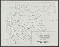
Creator:
Published / Created:
1944
Call Number:
36gmb 1944B
Container / Volume:
BRBL_00130
Image Count:
1
Resource Type:
Maps, Atlases & Globes
Description:
"No. 3167." and Dated: 13 April 1944.
Publisher:
OSS,
Subject (Geographic):
Germany--Maps
Subject (Topic):
Highway departments--Germany--Maps
Found in:
Beinecke Rare Book and Manuscript Library > Germany : principal road construction offices / compiled and drawn in the Branch of Research and Analysis, OSS.
Creator:
Published / Created:
1945
Call Number:
36cb 1945A
Container / Volume:
BRBL_00127
Image Count:
1
Resource Type:
Maps, Atlases & Globes
Description:
Dated: 7 April 1945., Includes most of western Poland., Inset: [Location map], and Relief indicated by color.
Publisher:
OSS,
Subject (Geographic):
Gdańsk Region (Poland)--Maps and Germany--Maps
Found in:
Beinecke Rare Book and Manuscript Library > Germany eastern border regions : surface configuration.
Branch:v1.61.6 ,Deployed:2024-06-12T09:55:37-04:00