Search
You Searched For
Search Results
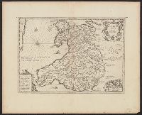
- Creator:
- Jansson, Jan, 1588-1664
Llwyd, Humphrey, 1527-1568
- Published / Created:
- ca. 1660]
- Call Number:
- 329 1660
- Container / Volume:
- BRBL_00074
- Image Count:
- 1
- Resource Type:
- Maps, Atlases & Globes
- Alternative Title:
- Cambriae typvs
- Publisher:
- Jan Jansson,
- Subject (Geographic):
- Wales--Maps--Early works to 1800
- Found in:
- Beinecke Rare Book and Manuscript Library > Cambriae typus [cartographic material] / auctore Humfredo Lhuydo.
- Published / Created:
- 1751
- Call Number:
- 3243 1751
- Container / Volume:
- BRBL_00066
- Image Count:
- 1
- Resource Type:
- Maps, Atlases & Globes
- Description:
- Preliminary record.
- Subject (Geographic):
- Cambridgeshire (England)--Maps--Early works to 1800
- Found in:
- Beinecke Rare Book and Manuscript Library > Cambridgeshire ... Eman: Bowen ... 1751.
- Published / Created:
- 1610
- Call Number:
- 3243 1610B
- Container / Volume:
- BRBL_00065
- Image Count:
- 2
- Resource Type:
- Maps, Atlases & Globes
- Description:
- Preliminary record. and Verso: A description of Cambridgshire and a table of the towns.
- Subject (Geographic):
- Cambridgeshire (England)--Maps--Early works to 1800
- Found in:
- Beinecke Rare Book and Manuscript Library > Cambridgshire described with the division of the hundreds, the Townes situation, with the Arme of the Colleges of that famous University. Performed by John Speed, 1610.
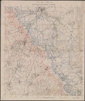
- Published / Created:
- 1610
- Call Number:
- 3243 1610A
- Container / Volume:
- BRBL_00065
- Image Count:
- 3
- Resource Type:
- Maps, Atlases & Globes
- Description:
- Preliminary record. and Verso: A description of Cambridgshire and a table of the towns.
- Subject (Geographic):
- Cambridgeshire (England)--Maps--Early works to 1800
- Found in:
- Beinecke Rare Book and Manuscript Library > Cambridgshire described with the division of the hundreds, the Townes situation, with the Arme of the Colleges of that famous University. Performed by John Speed, 1610.
- Creator:
- Canada. Topographical Survey
- Published / Created:
- 1936
- Call Number:
- 743 C14 1936
- Container / Volume:
- BRBL_00395
- Image Count:
- 1
- Resource Type:
- Maps, Atlases & Globes
- Description:
- Relief by contours & spot hts.; wooded & marshy areas.
- Publisher:
- Topographical Survey of Canada,
- Subject (Geographic):
- Cameron Bay Region (N.W.T.)--Maps
- Found in:
- Beinecke Rare Book and Manuscript Library > Cameron Bay, Northwest Territories [map] / compiled, drawn and printed ... by the Topographical Survey of Canada.
- Published / Created:
- 1917.
- Call Number:
- 777hc M461 1917
- Image Count:
- 1
- Description:
- "Based on information furnished by the Quartermaster's Department, U.S.A."
- Publisher:
- Maryland Geological Survey
- Subject (Geographic):
- Camp Meade (Maryland)
- Found in:
- Beinecke Rare Book and Manuscript Library > Camp Meade ; Admiral, Maryland
- Creator:
- Geological Survey (U.S.)
- Published / Created:
- 1917?]
- Call Number:
- 38hc L337 1917
- Container / Volume:
- BRBL_00173
- Image Count:
- 1
- Resource Type:
- Maps, Atlases & Globes
- Description:
- Shows "quadrille de Bonne en noir, quarillage Lambert en rouge." and WWI battle area NE of Lassigny, France.
- Subject (Geographic):
- Oise (France)--Maps
- Subject (Topic):
- World War, 1914-1918
- Found in:
- Beinecke Rare Book and Manuscript Library > Camp de Lassigny, Anciennes Organisations Francaises et Allemandes [cartographic material] / Engraved and printed by the U.S. Geological Survey.
- Creator:
- Geological Survey (U.S.)
- Published / Created:
- 1916?]
- Call Number:
- 38hc L337 1916
- Container / Volume:
- BRBL_00173
- Image Count:
- 1
- Resource Type:
- Maps, Atlases & Globes
- Description:
- Shows "quadrille de Bonne en noir, quarillage Lambert en rouge." and WWI battle area NE of Lassigny, France.
- Subject (Geographic):
- Oise (France)--Maps
- Subject (Topic):
- World War, 1914-1918 and World War, 1914-1918--Campaigns--France
- Found in:
- Beinecke Rare Book and Manuscript Library > Camp de Lassigny, Anciennes Organisations Francaises et Allemandes [cartographic material].
- Call Number:
- 402 M763 1840
- Container / Volume:
- BRBL_00233A
- Image Count:
- 3
- Resource Type:
- Maps, Atlases & Globes
- Subject (Geographic):
- Brescia (Italy)--Maps
- Subject (Name):
- Antonini, L and Caniani, J
- Found in:
- Beinecke Rare Book and Manuscript Library > Camp de Montechiaro et ses environs / gravé à Milan par L. Antonini, et J. Caniani.