Portugal. Comissão de Cartografia das Colónias, author
Call Number:
6514 1885
Container / Volume:
BRBL_00342
Image Count:
1
Resource Type:
Maps, Atlases & Globes
Description:
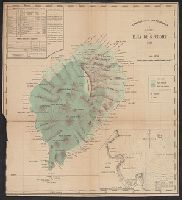
Imperfect: trimmed in lower left corner, with some loss of graticule., Inset: Planta da Bahia de Anna de Chaves., and Relief shown by hachures and spot heights.
Subject (Geographic):
São Tomé Island (Sao Tome and Principe)--Maps
Subject (Name):
Oliveira, A. A. de and Vasconcellos, Ernesto J. de C. e (Ernesto Julio de Carvalho), 1852-1930
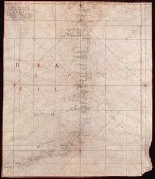
Color: red and black ink, longitude and latitude grid colored yellow., Coordinates not present on map and are approximated., and Includes information on seasonal currents.