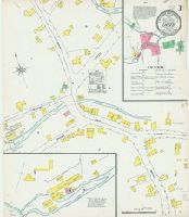
Sanborn fire insurance maps are a rich source of historic data on the urban built environment of North America during the 19th and early 20th centuries. The atlases were created for the purpose of underwriting fire insurance policies, which depended upon accurate and frequently-updated information about construction materials, municipal and transportation infrastructure, industrial and commercial landuse and more. The Yale University Library Map Department scanned its holdings of Sanborn fire insurance maps (consisting primarily of Connecticut towns) in order to make the maps more accessible.
Alternative Title:
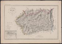
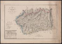
Nov. 1903, Chester, Conn.
Description:
"3 sheets, 6578.", Contains information on population, prevailing winds, water facilities and fire department., Includes index of specials., Partial cadastral map., and SMLMAPL 766 C426 1903: Sheets disbound. Library of Congress copyright stamp on title sheet.
Subject (Geographic):
Chester (Conn. : Town)--Maps
Subject (Name):
Library of Congress Stamp
Subject (Topic):
Fire risk assessment--Connecticut--Chester (Town)--Maps and Real property--Connecticut--Chester (Town)--Maps
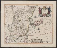
Coordinates approximated., From Ortelius's Theatro de la Tierra Universal (1588)., North oritented towards the right., Relief shown pictorially., Spanish text and pagination "93" on verso., and The first Western map of China based upon the reports of the Portugues
Subject (Geographic):
China--Maps--Early works to 1800
Subject (Name):
Barbuda, Luis Coello de, active 1607-1626, Ortelius, Abraham, 1527-1598. Theatrum orbis terrarum. Spanish, and Plantin, Christophe, approximately 1520-1589, printer
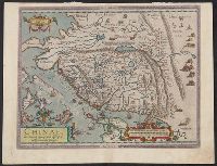
Navtica mediterranea / di Bartolomeo Crescentio Romano ... Nella quale si mostra la fabrica delle
Image Count:
1
Resource Type:
Maps, Atlases & Globes
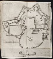
Description:
Includes bar scale labeled "canne"., Map bound in after p. 535., Negative image of the number 537 can be seen just to the right of the printed number 537 as noted above., and Printed in upper right corner: 537.
Subject (Geographic):
Civitavecchia (Italy) --Maps --Early works to 1800