Search
You Searched For
Search Results
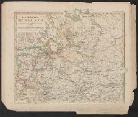
- Published / Created:
- [1910?]
- Call Number:
- 36 1618
- Image Count:
- 1
- Resource Type:
- Maps, Atlases & Globes
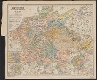
- Description:
- Insets: Belagerung von Antwerfen 1544 u 85 1:370,000, Nürnberg 1500 1:1,000,000, Wettinischen Lande ... 1547, Deutsche Reich ... 1512 - 1:10,600,000.
- Publisher:
- Justus Perthes,
- Subject (Geographic):
- Germany--Maps
- Found in:
- Beinecke Rare Book and Manuscript Library > Deutschland im Zeitraum der Reformation 1492 bis 1618 von B. Hassenstein.
- Published / Created:
- 1852
- Call Number:
- 36ef 1852
- Container / Volume:
- BRBL_00127
- Image Count:
- 1
- Resource Type:
- Maps, Atlases & Globes
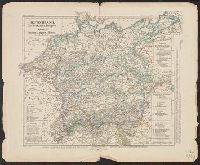
- Description:
- From Berghaus' Physikal Atlas.
- Publisher:
- J. Perthes,
- Subject (Geographic):
- Belgium--Maps, Europe, Central--Maps, Germany--Maps, Netherlands--Maps, and Switzerland--Maps
- Subject (Name):
- Berghaus, Heinrich Karl Wilhelm, 1797-1884. Dr. Heinrich Berghaus' physikalischer Atlas
- Found in:
- Beinecke Rare Book and Manuscript Library > Deutschland, Niederlande, Belgien und Sweiz : National-, Sprach-, Dialect Verschiedenheit.
- Creator:
- Justus Perthes (Firm : Gotha, Germany)
Vogel, C. (Carl), 1828-1897
- Published / Created:
- 1890-1891.
- Call Number:
- 44 1891
- Container / Volume:
- BRBL_00255
- Image Count:
- 4
- Resource Type:
- Maps, Atlases & Globes
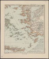
- Description:
- In lower right corner of maps: Stieler's Hand-Atlas No. 51-54.
- Publisher:
- Justus Perthes,
- Subject (Geographic):
- Balkan Peninsula--Maps
- Found in:
- Beinecke Rare Book and Manuscript Library > Die Balkan-Halbinsel in 4 Blättern : Türkei, Rumänien, Griechenland, Serbien, Montenegro, Bulgarien / von C. Vogel.
- Creator:
- Spruner von Merz, Karl, 1803-1892
- Published / Created:
- 1872-1876.
- Call Number:
- 38j
- Container / Volume:
- BRBL_00173
- Image Count:
- 7
- Resource Type:
- Maps, Atlases & Globes
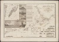
- Alternative Title:
- Hand-Atlas für die Geschichte des Mittelalters und der neueren Zeit., Spruner-Menke hist. Handatlas., and Spruner-Menke historischer Handatlas.
- Description:
- Cover title. and Running title: Spruner-Menke: Hist. Handatlas.
- Publisher:
- J. Perthes,
- Subject (Geographic):
- France--Maps
- Subject (Name):
- Menke, Th. (Theodor), 1819-1892
- Subject (Topic):
- Historical geography--Maps
- Found in:
- Beinecke Rare Book and Manuscript Library > Dr. K. v. Spruner's Hand-Atlas für die Geschichte des Mittelalters und der neueren Zeit. Frankreich.
- Creator:
- Hassenstein, Bruno
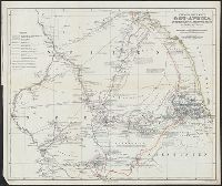
- Published / Created:
- 1861
- Call Number:
- 63 1861
- Container / Volume:
- BRBL_00334
- Image Count:
- 1
- Resource Type:
- Maps, Atlases & Globes
- Alternative Title:
- Ost-Afrika zwischen Chartúm & dem Rothen Meere
- Description:
- Includes text., Prime meridians: Paris and Greenwich., and Relief shown by hachures.
- Publisher:
- Justus Perthes,
- Subject (Geographic):
- Eritrea--Discovery and exploration--Maps, Ethiopia--Discovery and exploration--Maps, and Sudan--Discovery and exploration--Maps
- Subject (Name):
- Heuglin, Theodor von,--1824-1876 and Justus Perthes (Firm : Gotha, Germany)
- Found in:
- Beinecke Rare Book and Manuscript Library > Entwurf einer Karte von Ost-Afrika zwischen Chartúm & dem Rothen Meere, bis Sauakin und Massaua : nach allen vorhandenen Quellen entworfen von A. Petermann, zum Gebrauch der v. Heuglin'schen Expedition ausgeführt durch Justus Perthes' Geographisches Ans