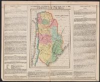
Engraved map, colored to show states and territories., Preliminary record., Resembles closely Melish: United States ... 1819., and Wash., London Prime mers.
At head of title: Department of the Interior, United States Geological Survey, J.W. Powell, director. and Contour lines drawn at 100, 500, 1000, 1500, 2000, and thence upward at each 1000 feet above sea level.
Publisher:
Engraved by Julius Bien & Co.,
Subject (Geographic):
United States--Maps
Subject (Name):
Gannett, Henry, 1846-1914 and King, Harry, (Harold G. R.)
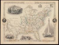
"The illustrations by J. Marchant & engraved by J. Rogers.", Probably from: The illustrated atlas, and modern history of the world, geographical, political, commercial, and statistical / Robert M. Martin. New York, [1857]., and Relief shown by hachures.
Publisher:
J. & F. Tallis,
Subject (Geographic):
United States--Maps.
Subject (Name):
John Tallis & Company, Marchant, J, and Rogers, John, approximately 1808-approximately 1888