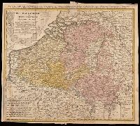
Belgium Catholicum seu decem provinciae Germaniae inferioris and Carte des Pais Bas catholiques où des X provinces de l'Allegmagne inférieure, etc. dessinée au juste selon les exactes observations astronomiques et opérations géometriques des Messur. Cass
Description:
"Avec privil. Imperial" above neat line., Includes 8 bar scales., Includes coats-of-arms of ten provinces., Relief shown pictorially., and Watermark. Manuscript number in upper right corner: 262[?]. From the Karpinski-von Wieser Map Collection.
Publisher:
Edentibus Homannianis heredib.,
Subject (Geographic):
Belgium--Maps--Early works to 1800. and Luxembourg--Maps--Early works to 1800.
Subject (Name):
Cassini, César-François, 1714-1784, Homann Erben (Firm), and Snellius, Willebrord, 1580-1626
Tardieu, P. F. (Pierre François), 1757-1822, author
Call Number:
451 1770
Container / Volume:
BRBL_00258
Image Count:
1
Resource Type:
Maps, Atlases & Globes
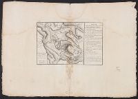
Description:
"A. Pl. 34.", Bar scales given in "Echelle de 600 Sagenes" and "Echelle de 600 Toises.", Coordinates not present on map and are approximated, From Nicolas-Gabriel Clerc's Histoire physique, morale, civile et politique de la Russie moderne., and Includes legend to
Subject (Geographic):
Bender (Moldova)--Maps--Early works to 1800
Subject (Name):
Clerc, Nicolas-Gabriel, 1726-1798. Histoire physique, morale, civile et politique de la Russie moderne
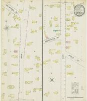
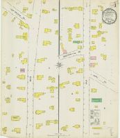
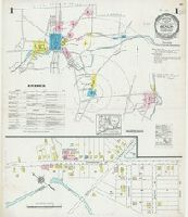
Sanborn fire insurance maps are a rich source of historic data on the urban built environment of North America during the 19th and early 20th centuries. The atlases were created for the purpose of underwriting fire insurance policies, which depended upon accurate and frequently-updated information about construction materials, municipal and transportation infrastructure, industrial and commercial landuse and more. The Yale University Library Map Department scanned its holdings of Sanborn fire insurance maps (consisting primarily of Connecticut towns) in order to make the maps more accessible.
Alternative Title:
Nov. 1887, Berlin, Conn.
Description:
"2 sheets.", Contains information on population, prevailing winds, water facilities and fire department., Partial cadastral map., and SMLMAPL 766 B45 1887: Sheets disbound. "Triplicate" stamp on all sheets.
Subject (Geographic):
Berlin (Conn.)--Maps
Subject (Topic):
Fire risk assessment--Connecticut--Berlin--Maps and Real property--Connecticut--Berlin--Maps
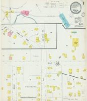
Sanborn fire insurance maps are a rich source of historic data on the urban built environment of North America during the 19th and early 20th centuries. The atlases were created for the purpose of underwriting fire insurance policies, which depended upon accurate and frequently-updated information about construction materials, municipal and transportation infrastructure, industrial and commercial landuse and more. The Yale University Library Map Department scanned its holdings of Sanborn fire insurance maps (consisting primarily of Connecticut towns) in order to make the maps more accessible.
Alternative Title:
Aug. 1895, Berlin, Conn. and Berlin, Conn.
Description:
"3 sheets, 8118.", Contains information on population, prevailing winds, water facilities and fire department., Partial cadastral map., and SMLMAPL 766 B45 1895: Sheets disbound. "Triplicate" stamp on all sheets. Library of Congress copyright stamp on title sheet.
Subject (Geographic):
Berlin (Conn.)--Maps
Subject (Name):
Library of Congress Stamp
Subject (Topic):
Fire risk assessment--Connecticut--Berlin--Maps and Real property--Connecticut--Berlin--Maps
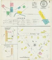
Sanborn fire insurance maps are a rich source of historic data on the urban built environment of North America during the 19th and early 20th centuries. The atlases were created for the purpose of underwriting fire insurance policies, which depended upon accurate and frequently-updated information about construction materials, municipal and transportation infrastructure, industrial and commercial landuse and more. The Yale University Library Map Department scanned its holdings of Sanborn fire insurance maps (consisting primarily of Connecticut towns) in order to make the maps more accessible.
Alternative Title:
Aug. 1901, Berlin, Conn. and Berlin, Conn.
Description:
"4 sheets (4904).", Contains information on population, prevailing winds, water facilities and fire department., Includes index of specials., Partial cadastral map., and SMLMAPL 766 B45 1901: Sheets disbound. "Triplicate" stamp on all sheets. Library of Congress copyright stamp on title sheet.
Subject (Geographic):
Berlin (Conn.)--Maps
Subject (Name):
Library of Congress Stamp
Subject (Topic):
Fire risk assessment--Connecticut--Berlin--Maps and Real property--Connecticut--Berlin--Maps
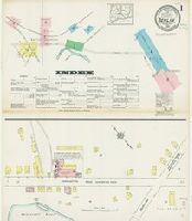
Sanborn fire insurance maps are a rich source of historic data on the urban built environment of North America during the 19th and early 20th centuries. The atlases were created for the purpose of underwriting fire insurance policies, which depended upon accurate and frequently-updated information about construction materials, municipal and transportation infrastructure, industrial and commercial landuse and more. The Yale University Library Map Department scanned its holdings of Sanborn fire insurance maps (consisting primarily of Connecticut towns) in order to make the maps more accessible.
Alternative Title:
April 1908, Berlin, Conn. and Berlin, Conn.
Description:
"8 sheets, #217.", Contains information on population, prevailing winds, water facilities and fire department., Includes index of streets and specials., Partial cadastral map., and SMLMAPL 766 B45 1908: Sheets disbound. "Triplicate" stamp on all sheets. Library of Congress copyright stamp on title sheet.
Subject (Geographic):
Berlin (Conn.)--Maps
Subject (Name):
Library of Congress Stamp
Subject (Topic):
Fire risk assessment--Connecticut--Berlin--Maps and Real property--Connecticut--Berlin--Maps
Sanborn fire insurance maps are a rich source of historic data on the urban built environment of North America during the 19th and early 20th centuries. The atlases were created for the purpose of underwriting fire insurance policies, which depended upon accurate and frequently-updated information about construction materials, municipal and transportation infrastructure, industrial and commercial landuse and more. The Yale University Library Map Department scanned its holdings of Sanborn fire insurance maps (consisting primarily of Connecticut towns) in order to make the maps more accessible.
Alternative Title:
Apr. 1914, Berlin, Conn. and Berlin, Conn.
Description:
"6794 (9 sheets).", Contains information on population, prevailing winds, water facilities and fire department., Includes index of streets and specials., Partial cadastral map., and SMLMAPL 766 B45 1914: Imperfect: sheet 1 torn, with no loss of text. Sheets disbound. "Triplicate" stamp on all sheets. Library of Congress copyright stamp on title sheet.
Subject (Geographic):
Berlin (Conn.)--Maps
Subject (Name):
Library of Congress Stamp
Subject (Topic):
Fire risk assessment--Connecticut--Berlin--Maps and Real property--Connecticut--Berlin--Maps
Sanborn fire insurance maps are a rich source of historic data on the urban built environment of North America during the 19th and early 20th centuries. The atlases were created for the purpose of underwriting fire insurance policies, which depended upon accurate and frequently-updated information about construction materials, municipal and transportation infrastructure, industrial and commercial landuse and more. The Yale University Library Map Department scanned its holdings of Sanborn fire insurance maps (consisting primarily of Connecticut towns) in order to make the maps more accessible.
Alternative Title:
Berlin, Conn. and May 1927, Berlin, Conn.
Description:
"(3146) 8 sheets.", Contains information on population, prevailing winds, water facilities and fire department., Includes index of streets and specials., Partial cadastral map., and SMLMAPL 766 B45 1927: Sheets disbound.
Subject (Geographic):
Berlin (Conn.)--Maps
Subject (Topic):
Fire risk assessment--Connecticut--Berlin--Maps and Real property--Connecticut--Berlin--Maps