Geological Survey (U.S.) United States. Army Map Service
Published / Created:
1974
Call Number:
234 1974
Container / Volume:
BRBL_00020
Image Count:
1
Resource Type:
Maps, Atlases & Globes
Alternative Title:
Series (Standard map series designation system) ; W532. and Series , W532
Description:
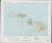
"10,000-meter Universal Mercator grid ticks, zones 4 and 5, international spheroid, shown in blue.", "Hawaiian Islands 1:250,000"--Upper margin., "Maui, Hawaii"--Lower margin., "NF 4-16" -- Upper margin., "Prepared by the Army Map S, and Includes location diagram.
Publisher:
For sale by the Survey, and U.S. Geological Survey ;
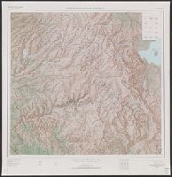
"Compiled in 1963 from 1:62,500-scale maps dated 1947, 1953, 1956, and 1958.", "N3728--W11900/45X60.", Includes location map and USGS index map., and Relief shown by shading, contours, and spot heights.