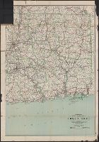
Includes the eastern part of Connecticut from Hartford east to the Rhode Island border. and Indicates best and fair roads, interurban electric railways, and railroads.
Publisher:
C.S. Hammond & Co.,
Subject (Geographic):
Connecticut--Maps
Subject (Name):
Geological Survey (U.S.) and U.S. Coast and Geodetic Survey
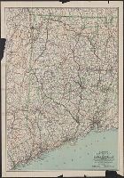
Includes the western part of Connecticut from The New York border to West Hartford and New Britain. and Indicates main auto routes and state improved roads, interurban electric lines, and railroads.
Publisher:
C.S. Hammond & Co.,
Subject (Geographic):
Connecticut--Maps
Subject (Name):
Geological Survey (U.S.) and U.S. Coast and Geodetic Survey
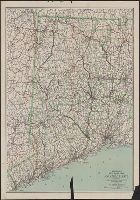
Includes the western part of Connecticut from The New York border to West Hartford and New Britain. and Indicates main auto routes and state improved roads, interurban electric lines, and railroads.
Publisher:
C.S. Hammond & Co.,
Subject (Geographic):
Connecticut--Maps
Subject (Name):
Geological Survey (U.S.) and U.S. Coast and Geodetic Survey
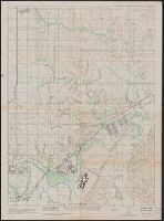
"Compiled at T.C.S. Jan. 1946 from revision of 30 Nov. 1943 from seven mile, Magic, Oak View east & west sheet.", "N 3902.12 W 9641.58 8.6 x 8.7.", "Reproduced at Fort Riley, Kansas H-277-1-2-3-4.", and Relief shown by contours and spot heights.
Publisher:
s.n.,
Subject (Geographic):
Fort Riley Region (Kan.)--Maps
Subject (Name):
Geological Survey (U.S.), U.S. Coast and Geodetic Survey, United States. Army. Corps of Engineers. Little Rock District, and United States. Army. Photographic Squadron, 1st