Search
You Searched For
Search Results
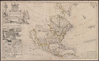
- Creator:
- Moll, Herman, -1732
- Published / Created:
- 1720
- Call Number:
- 71 1720C
- Container / Volume:
- BRBL_00687
- Image Count:
- 1
- Resource Type:
- Maps, Atlases & Globes
- Found in:
- Beinecke Rare Book and Manuscript Library > A new map of the north parts of America claimed by France under ye names of Louisiana, Mississipi, Canada and New France with ye adjoyning territories of England and Spain ... : the projection of this map is call'd Mercator's, and it is laid down accordin
- Creator:
- Moll, Herman, -1732
- Published / Created:
- 1720
- Call Number:
- 71 1720C
- Container / Volume:
- BRBL_00361
- Image Count:
- 1
- Resource Type:
- Maps, Atlases & Globes
- Found in:
- Beinecke Rare Book and Manuscript Library > A new map of the north parts of America claimed by France under ye names of Louisiana, Mississipi, Canada and New France with ye adjoyning territories of England and Spain ... : the projection of this map is call'd Mercator's, and it is laid down accordin
- Creator:
- Moll, Herman, d. 1732
- Published / Created:
- [1720]
- Call Number:
- 71 1720D
- Container / Volume:
- BRBL_00361
- Image Count:
- 1
- Resource Type:
- Maps, Atlases & Globes
- Found in:
- Beinecke Rare Book and Manuscript Library > To the right honourable John Lord Sommers, Baron of Evesham in ye county of Worcester, president of Her Majesty's most honourable Privy Council &c., this map of North America, according to ye newest and most exact observations is most humbly dedicated by