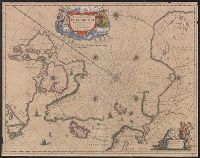
Nova et accvrata Poli Arctici et terrarum circum Iacentium descriptio
Description:
Cross collection no. 51., From: Nouvel atlas, ou, Theatre du Monde ... Amstelodami : Apud Ioannem Ianssonium, 1649., In Latin, with French text on verso; running title "Description"; caption title "Le pole Arctique avec les regions situees dessous"; sig. P., and Includes ill. and decorative cartouche.
Publisher:
Apud Ioannem Ianssonium,
Subject (Geographic):
Arctic Regions--Maps--Early works to 1800
Subject (Name):
Jansson, Jan, 1588-1664. Nouvel atlas, ou, theatre du monde
Hand col. Sheet measures 47 x 58 cm., Has watermarks., Includes decorative cartouche and ill., Latin, with French text on verso., On verso, right top margin: 313., Relief shown pictorially., and Signature on verso: Xxxxxx.
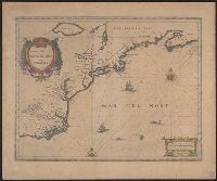
Appears in French editions of Jansson's and Hondius's Atlas n, French text on verso, with signature 5d., Hand col. Sheet measures 47.5 x 57 cm., Relief shown pictorially., and Stamp on verso: Yale University Library Karpinski-von Wieser Map Collection.
Publisher:
Johannes Janssonius excudit,
Subject (Geographic):
Atlantic States--Maps--Early works to 1800 and Maritime Provinces--Maps--Early works to 1800
Subject (Name):
Hondius, Hendrik, 1597-1651. Atlas novus. French and Jansson, Jan, 1588-1664. Atlas novus. French
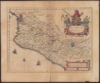
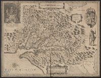
Bar scale given in "milliaria Hispanica.", Cross Collection no. 311., From Blaeu's Le theatre du monde ... Amsterdami : Apud Guiljelmum et Iohannem Blaeu, 1635., Imperfect: torn half-way along fold., In French on verso, with caption title "La novvelle Espagne" and signature C6., Includes "Notarum explanatio" and ill., and Relief shown pictorially.
Publisher:
Willem and Joan Blaeu,
Subject (Geographic):
Mexico--Maps--Early works to 1800
Subject (Name):
Blaeu, Joan, 1596-1673. Theatrum orbis terrarum. French and Blaeu, Willem Janszoon, 1571-1638. Theatrum orbis terrarum. French
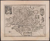
French text on verso, with running and caption title "Virginie," signature e, and catchword "ses.", From Jan Jansson's Nouvel atlas ... Amstelodami : Apud Ioannem Ianssonium, 1646-1649., Hendrik Hondius' derivative of John Smith's map of Virginia, 1612., and Ori
Publisher:
Ex officina Henrici Hondii,
Subject (Geographic):
Chesapeake Bay (Md. and Va.)--Maps--Early works to 1800, Maryland--Maps--Early works to 1800, and Virginia--Maps--Early works to 1800
Subject (Name):
Jansson, Jan, 1588-1664. Atlas novus. French and Smith, John, 1580-1631
Hendrik Hondius' derivative of John Smith's map of Virginia, 1612., Oriented with north to the right., Relief shown pictorially., Sheet measures 47.6 x 57.7 cm. Franklin Collection no. 131 1633., and Verso in French, with running and caption title "Description de la Virginie," signatures 8O2, and catchword "peu".
Publisher:
Ex officina Henrici Hondii,
Subject (Geographic):
Chesapeake Bay (Md. and Va.)--Maps--Early works to 1800, Maryland--Maps--Early works to 1800, and Virginia--Maps--Early works to 1800
Subject (Name):
Jansson, Jan, 1588-1664. Atlas novus. French and Smith, John, 1580-1631
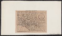
Based on John Smith's map of Virginia., From Gerardus Mercator's Altas minor (French ed.) ... A Amsterdam : Chez Iean Iansson, 1630., Map in Latin, with pagination "631." Text on verso in French., Mounted on paper. Sheet measures 14.5 x 20.3 cm. Cross Collection no. 209., Oriented with north towards the right., and Relief shown pictorially.
Publisher:
Jan Jansson,
Subject (Geographic):
Virginia--Maps--Early works to 1800
Subject (Name):
Keere, Pieter van den, 1571-ca. 1646, Mercator, Gerhard, 1512-1594. Atlas minor. French, and Smith, John, 1580-1631
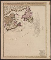
Carte nouvelle contenant la partie d'Amerique la plus septentrionale : ou sont exactement dêcrites les provinces suivantes comme le Canada ou Nouvelle France, la Nouvelle Ecosse, la Nouvelle Angleterre, les Nouveaux Paı̈s Bas, la Pensylvanie, la Virginie
Description:
"Cum privilegio ordinum generalium foederati Belgii.", Appears in some eds. of the author's Atlas minor sive geographia compendiosa., Library copy incomplete, Atlantic Canada sheet only; damaged in upper left., and Relief shown pictorially. Depths shown by sound
Publisher:
Nicolao Visscher,
Subject (Geographic):
Atlantic Provinces--Maps--Early works to 1800 and North America--Maps--Early works to 1800
Subject (Name):
Anse, Luggert van, fl. 1690-1716, engraver and Visscher, Nicolaes, 1649-1702. Atlas minor sive geographia compendiosa
Blaeu, Willem Janszoon, 1571-1638 Blaeu, Willem Janszoon, 1571-1638. Theatrum orbis terrarum. French Ende, Josua van den, ca. 1584-ca. 1634 Hooft, Cornelis Pieterszoon, 1547-1626
Published / Created:
[between 1635 and 1650]
Call Number:
11 1635
Container / Volume:
BRBL_00003
Image Count:
2
Resource Type:
Maps, Atlases & Globes
Description:
Appears in the author's Theatrum orbis terrarum. 1635., Dedicated to "Cornelio Petri fan Hooft.", Described in: The mapping of the world / Rodney W. Shirley. London : Holland Press, 1983. No. 255, state 4., Includes insets of the po, and Relief shown pictorially.