
You Searched For
1 - 4 of 4
Search Results
2.
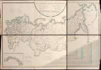
- Creator:
- Pi︠a︡dyshev, Vasiliĭ Petrovich, 1768-1835.
Пядышев, Василий Петрович, 1768-1835. - Published / Created:
- 1820-1827.
- Call Number:
- EEdb 828P
- Image Count:
- 1
- Resource Type:
- Maps, Atlases & Globes
- Alternative Title:
- Atlas géographique de l'empire de Russie, du royaume de Pologne and du grand duché de Finlande and Географическій атлас Россійской Имперіи Царства Польскаго и Великаго Княжества Финляндскаго : расположенный по губерніям на 80 листах ... с генеральною картою ... / сочинен по новѣйшим и достовѣрным свѣденіям ... Пядышевым, начат 1820-го, окончен 1827-го года = Atlas géographique de l'empire de Russie, du royaume de Pologne et du grand duché de Finlande ; divisé en gouvernements ... ; avec une carte générale ... / composé ... par ... Pi︠a︡discheff ...
- Description:
- Captions and place names in Russian and Polish or in Russian and French., Relief shown by spot heights., and Some maps composed of two or more leaves hinged with cloth.
- Publisher:
- [publisher not identified],
- Subject (Geographic):
- Soviet Union.--(OCoLC)fst01210281 and Soviet Union--Maps.
- Found in:
- Beinecke Rare Book and Manuscript Library > Geograficheskīĭ atlas Rossīĭskoĭ Imperīi T︠s︡arstva Polʹskago i Velikago Kni︠a︡zhestva Finli︠a︡ndskago [cartographic material] : raspolozhennyĭ po gubernīi︠a︡m na 80 listakh ... s generalʹnoi︠u︡ kartoi︠u︡ ... / sochinen po novi︠e︡ĭshim i dostovi︠e︡rnym svi︠e︡denīi︠a︡m ... Pi︠a︡dyshevym, nachat 1820-go, okonchen 1827-go goda = Atlas géographique de l'empire de Russie, du royaume de Pologne et du grand duché de Finlande ; divisé en gouvernements ... ; avec une carte générale ... / composé ... par ... Pi︠a︡discheff ...
3.
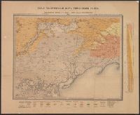
- Creator:
- Sokolov, N
Соколовъ, Н - Published / Created:
- 1889
- Call Number:
- 352ca 1889
- Container / Volume:
- BRBL_00108
- Image Count:
- 1
- Resource Type:
- Maps, Atlases & Globes
- Alternative Title:
- Carte géologique générale de la Russie d'Europe. and Общая геологическая карта европеиІскоиІ России. Лист 48. Мелитополь, Бердянскъ, Перекопъ, Бериславлъ / составиль Н. Соколовъ = Carte géologique générale de la Russie d'Europe. Feuille 48. Melitopol, B
- Description:
- Mounted on linen.
- Publisher:
- Kartograficheskoe zavedenie A. Nlʹina, and Картографическое заведение А. Нльина,
- Subject (Geographic):
- Ukraine--Maps
- Found in:
- Beinecke Rare Book and Manuscript Library > Obshchai︠a︡ geologicheskai︠a︡ karta evropeĭskoĭ Russii. List 48. Melitopolʹ, Berdi︠a︡nsk, Perekop, Berislavl / sostavil N. Sokolov = Carte géologique générale de la Russie d'Europe. Feuille 48. Melitopol, Berdiansk, Perekop, Berislav / dressée par N
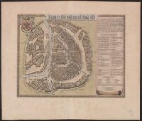
4.

- Creator:
- Savinkov, A
- Published / Created:
- 1832]
- Call Number:
- 352 Sa25 1832
- Container / Volume:
- BRBL_00108
- Image Count:
- 1
- Resource Type:
- Maps, Atlases & Globes
- Alternative Title:
- Plan de la ville capitale de St. Petersburg
- Description:
- Includes text, indexes, and indexed illus. of fire signals. and Relief shown by hachures.
- Publisher:
- s.n.,
- Subject (Geographic):
- Saint Petersburg (Russia)--Maps
- Subject (Topic):
- Fire prevention--Russia (Federation)--Saint Petersburg--Maps
- Found in:
- Beinecke Rare Book and Manuscript Library > Plan stolichnago goroda Sanktpeterburga = Plan de la ville capitale de St. Petersbourg / Sedʹmago klassa i kaval: A. Savinkovym.