Skip to search
Skip to main content
Skip to first result
Search
You Searched For
Genre
Maps
Creator
Rand McNally and Company
Subject (Name)
Missouri Pacific Railway Company--Maps
New Search
Search Results
Creator:
Published / Created:
1900
Call Number:
80gme 1900A
Container / Volume:
BRBL_00540
Image Count:
1
Resource Type:
Maps, Atlases & Globes
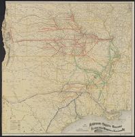
Description:
Relief shown by hachures.
Publisher:
Rand McNally,
Subject (Name):
Missouri Pacific Railway Company--Maps and St. Louis, Iron Mountain, and Southern Railway Company--Maps
Subject (Topic):
Railroads--Southwest, Old--Maps
Found in:
Beinecke Rare Book and Manuscript Library > Map of the Missouri Pacific Railway : St. Louis, Iron Mt. & Southern Ry, leased, operated & independent lines & connections.
Creator:
Published / Created:
(Chicago : and [1886], c1883
Call Number:
75gme 1883B
Container / Volume:
BRBL_00413
Image Count:
2
Resource Type:
Maps, Atlases & Globes
Alternative Title:
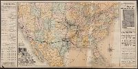
Missouri Pacific Railway for Kansas City and all points west
Description:
"Form 1. C D--1-15, 86.", Includes list of agents, fare chart, text and illus., Relief shown by hachures., and Timetables and tourist information on verso ([18] p.).
Publisher:
Missouri Pacific Railway,
Subject (Name):
Missouri Pacific Railway Company and Missouri Pacific Railway Company--Maps
Subject (Topic):
Railroads--Mexico--Maps and Railroads--United States--Maps
Found in:
Beinecke Rare Book and Manuscript Library > Map of the South West railway system : Missouri Pacific Ry., Central Branch U.P.R.R., Missouri, Kansas & Texas Ry., Texas and Pacific Ry., St. Louis, Iron Mountn. and Southern Ry., International and Great Northern Ry. and their connections / Rand McNally
Branch:v1.61.6 ,Deployed:2024-06-12T09:55:36-04:00