Skip to search
Skip to main content
Skip to first result
Search
You Searched For
Genre
Maps
Language
English
Subject (Topic)
World War, 1914-1918--Maps
New Search
Search Results
Creator:
Published / Created:
1915
Call Number:
11hcf 1919E-10
Image Count:
1
Resource Type:
Maps, Atlases & Globes
Alternative Title:
Europe 1:1,000,000, G.S.G.S. ; no. 2758, and GSGS (Series) ; no. 2758.
Description:
Includes index to adjoining sheets, index to boundaries, and pronunciation glossary.
Publisher:
Ordnance Survey,
Subject (Geographic):
Croatia--Maps, Italy--Maps, and Yugoslavia--Maps
Subject (Name):
Seymour, Charles,--1885-1963--Autograph
Subject (Topic):
World War, 1914-1918--Maps
Found in:
Beinecke Rare Book and Manuscript Library > Triest : North L 33. / compiled at the Royal Geographical Society under the direction of the Geographical Section; drawn and printed by Ordnance Survey.
Published / Created:
[1916?]
Call Number:
11hc 1914R
Container / Volume:
BRBL_00010B
Image Count:
1
Resource Type:
Maps, Atlases & Globes
Description:
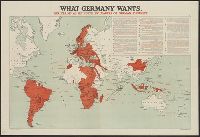
Date taken from text., In upper right corner: "14.", and Includes inset of quotations describing Germany's war aims.
Publisher:
Stanford's Geographical Establishment,
Subject (Geographic):
World maps
Subject (Topic):
World War, 1914-1918--Germany--War aims and World War, 1914-1918--Maps
Found in:
Beinecke Rare Book and Manuscript Library > What Germany wants : her claims as set forth by leaders of German thought.
Creator:
Published / Created:
[1918]
Call Number:
11hc 1917A
Container / Volume:
BRBL_00010D
Image Count:
1
Resource Type:
Maps, Atlases & Globes
Description:
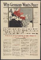
Includes "the Pan-German Plan as realized by War in Europe and in Asia, March 16, 1918"; shows colored map of Central Europe and its annexes in the Near East (Germany, Austria-Hungary, Bulgaria, Turkey); territory occupied or controlled by Central Powers;
Publisher:
Committee on Public Information,
Subject (Geographic):
Germany--Maps
Subject (Topic):
World War, 1914-1918--Maps
Found in:
Beinecke Rare Book and Manuscript Library > Why Germany wants peace : every American ought to know why we entered this War; every American ought to know why this conflict must continue until our aims are achieved; the publications listed below will give you this information.
Published / Created:
1940
Call Number:
11hc 1915C
Container / Volume:
BRBL_00010B
Image Count:
2
Resource Type:
Maps, Atlases & Globes
Description:
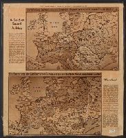
Includes ill. maps and text: "Printed about 1915 ... what would happen if the Allies won, a fearsome propaganda picture for the common German soldier ... were contained in an envelope which said The Map of Europe, how our enemies want to shape it and how
Publisher:
Herald Tribune,
Subject (Geographic):
Europe--Maps
Subject (Topic):
World War, 1914-1918--Maps
Found in:
Beinecke Rare Book and Manuscript Library > [A soldier saved a map.]
Published / Created:
191-.
Call Number:
11hcf 1919A-31
Container / Volume:
BRBL_00010N
Image Count:
2
Resource Type:
Maps, Atlases & Globes
Description:
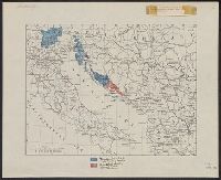
Shows territories "delimited by the Treaty of London" and "additional territory claimed in this memorandum."
Publisher:
s.n.,
Subject (Geographic):
Italy--Maps
Subject (Topic):
World War, 1914-1918--Maps
Found in:
Beinecke Rare Book and Manuscript Library > [Italian claims along the Adriatic Sea.]
Branch:v1.61.6 ,Deployed:2024-06-12T09:55:19-04:00