
You Searched For
1 - 10 of 10
Search Results
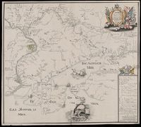
2.
- Creator:
- Seutter, Matthaeus, 1678-1756
- Published / Created:
- [1736]
- Call Number:
- BrSides Double Folio 2019 19
- Image Count:
- 1
- Resource Type:
- Maps, Atlases & Globes
- Alternative Title:
- Nachricht von denen gegen die Türcken und Tartarn in diesem 1736sten Jahre vorgefallenen Kriegs-Operationen der Russisch-Kayserlichen Armée.
- Description:
- Imperfect: chipped along edges, with some loss of text. Reinforced with paper at top. Manuscript number 76 in upper right corner. Manuscript waste pasted to verso. From the Karpinski-von Wieser Map Collection., Includes index., Map flanked by text: "Nachricht von denen gegen die Türcken und Tartarn in diesem 1736sten Jahre vorgefallenen Kriegs-Operationen der Russisch-Kayserlichen Armée.", and Relief shown pictorially.
- Publisher:
- Zu haben bey Matthaeus Seutter
- Subject (Geographic):
- Russia--History, Military--18th century--Maps--Early works to 1800., Ukraine, Ukraine--History, Military--18th century--Maps--Early works to 1800., and Ukraine--Maps--Early works to 1800.
- Subject (Name):
- Imperatorskai︠a︡ akademīi︠a︡ nauk (Russia) and Russo-Turkish War (1736-1739)
- Subject (Topic):
- Military campaigns and Russo-Turkish War, 1736-1739--Campaigns--Ukraine--Maps--Early works to 1800.
- Found in:
- Beinecke Rare Book and Manuscript Library > Charte der Kriegs Operationen am Donn u. Dnieper Ihro russich kayserl. Majestaet glorieusen Armeen A. 1736 / gestochen bey der Kayserl. Wissensch. Acad. in St. Petersburg.
3.
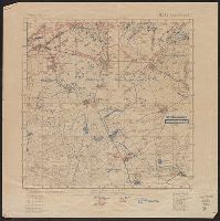
- Published / Created:
- 1918?]
- Call Number:
- 38hc 1918C
- Container / Volume:
- BRBL_00172
- Image Count:
- 1
- Resource Type:
- Maps, Atlases & Globes
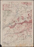
- Description:
- "Abgeschlossen am 18.7.18"., In upper right margin: Bl. 142, Bernécourt., Legend indicates trench information in red and blue ink., and Ms. annotations in German indicating trench information.
- Publisher:
- s.n.,
- Subject (Geographic):
- Lorraine (France)--Military maps
- Subject (Topic):
- World War, 1914-1918--France--Lorraine and World War, 1914-1918--Maps
- Found in:
- Beinecke Rare Book and Manuscript Library > Grabenkarte.
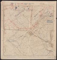
- Published / Created:
- 1918?]
- Call Number:
- 38hc 1918B
- Container / Volume:
- BRBL_00172
- Image Count:
- 6
- Resource Type:
- Maps, Atlases & Globes
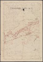
- Description:
- Legend indicates trench information in red and blue ink., Northeast, northwest, and southwest corners of Bl. 142, Bernécourt., and Northeastern sheet: "Abgeschlossen am 10.6.18"; Northwestern sheet: "Abgeschlossen am 20.5.18"; Southwestern sheet: "Abgeschlosse am 20.5.18"; Southwestern sheet: "Abgeschlossen am 17.6.18".
- Publisher:
- s.n.,
- Subject (Geographic):
- Lorraine (France)--Military maps
- Subject (Topic):
- World War, 1914-1918--France--Lorraine and World War, 1914-1918--Maps
- Found in:
- Beinecke Rare Book and Manuscript Library > Grabenkarten.
- Published / Created:
- 1918?]
- Call Number:
- 38hc 1918D
- Container / Volume:
- BRBL_00172
- Image Count:
- 2
- Resource Type:
- Maps, Atlases & Globes
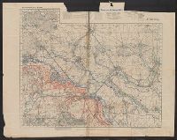
- Description:
- "19./6.-26./6./18"., Legend indicates weekly artillery information in red ink, roads, barriers, and trenches in green ink., Ms. annotations in German indicating artillery locations., and Verso: Map of other parts of same regions, with trenches indicated in red ink, new roads indicated in green ink.
- Publisher:
- s.n.,
- Subject (Geographic):
- Île-de-France (France)--Military maps and Lorraine (France)--Military maps
- Subject (Topic):
- World War, 1914-1918--France--Lorraine and World War, 1914-1918--Maps
- Found in:
- Beinecke Rare Book and Manuscript Library > Gruppe Gorz, Ic/IId No. 62 geh. Artillerie-Wochenkarte mit Truppen und Fliegerbilderkundung.
- Published / Created:
- 1918?]
- Call Number:
- 38hc 1918E
- Container / Volume:
- BRBL_00172
- Image Count:
- 1
- Resource Type:
- Maps, Atlases & Globes
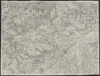
- Description:
- Ms. annotations in black and red ink.
- Publisher:
- s.n.,
- Subject (Geographic):
- Lorraine (France)--Military maps
- Subject (Topic):
- World War, 1914-1918--France--Lorraine and World War, 1914-1918--Maps
- Found in:
- Beinecke Rare Book and Manuscript Library > Minenwerfer-Karte, Div. "H".

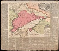
- Published / Created:
- [1788?]
- Call Number:
- BrSides Folio 2019 52
- Image Count:
- 1
- Resource Type:
- Maps, Atlases & Globes
- Description:
- Includes inset map: "Sieg der russisch kaiserlichen Truppen über die Türken bey Gangura". and Relief shown pictorially.
- Subject (Geographic):
- Bender (Moldova)--Maps--Early works to 1800.
- Subject (Topic):
- Fortification--Moldova--Bender--Maps--Early works to 1800.
- Found in:
- Beinecke Rare Book and Manuscript Library > Plan der Festung Bender : A. nachdem die russisch kaiserliche Truppen unter Commando des General Kamenskoy in 3 Colonnen die Türke bey B. in Gangura und bey C. Salkuza den 20 December 1788 überfallen und in die Flucht geschlagen ...

- Published / Created:
- 1940
- Call Number:
- 11hd 1945G-1
- Container / Volume:
- BRBL_00010ZF
- Image Count:
- 1
- Resource Type:
- Maps, Atlases & Globes
- Description:
- Ms. notes in German indicating camps and outposts.
- Publisher:
- Württ. Innenminister-Hauptvermessungsabteilung XII,
- Subject (Geographic):
- Baden-Württemberg (Germany)--Maps
- Found in:
- Beinecke Rare Book and Manuscript Library > Topographische Karte, 1:25,000. 7322, Kirchheim.
9.
- Published / Created:
- [1918]
- Call Number:
- 38hc R283 1918
- Container / Volume:
- BRBL_00173
- Image Count:
- 10
- Resource Type:
- Maps, Atlases & Globes
- Description:
- Copious ms. notes on maps. Accompanied by: 1) TLS from Alexander O. Vietor to Dr. Albrecht Goetze dated May 1, and III. Btl. J.R. Jaud. 18.3.18, 1:10,000 -- Regl. Jaud 21.3.18, 1:10,000 -- Remenauville, 1:2,500 -- 5. Cormicy, 1:25,000.
- Subject (Geographic):
- World War, 1914-1918--Battlefields--France--Lorraine--Maps and World War, 1914-1918--Personal narratives, German
- Subject (Name):
- Götze, Albrecht,--1897-1971 and Götze, Albrecht,--1897-1971--Ownership
- Found in:
- Beinecke Rare Book and Manuscript Library > [Collection of maps related to raid of the Second Battalion Infantry Regiment 134 near Remenauville during the night of April 27/28 1918].
- Published / Created:
- 1945?]
- Call Number:
- 11hd 1945G-3
- Container / Volume:
- BRBL_00010ZF
- Image Count:
- 1
- Resource Type:
- Maps, Atlases & Globes
- Description:
- Ms. notes in German. and Titile supplied by cataloger.
- Publisher:
- s.n.,
- Subject (Geographic):
- Baden-Württemberg (Germany)--Maps
- Found in:
- Beinecke Rare Book and Manuscript Library > [Karte des Deutschen Reiches 1:100,000, Ulm and vicinity]