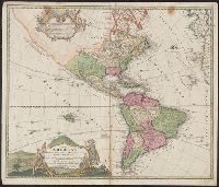
America occidentalium indiarum nomine Vulgo celebratissima non i[m]merito Europa Nova appellari posset
Description:
2nd state, with California correctly shown as a peninsula., Appears in Homann's Atlas novus., Mounted on linen. Sheet measures 54.4 x 61 cm. Stamp on verso: Yale University Library, Karpinski-Von Wieser Map Collection., Prime meridian: Teneriffe., and Rel
America occidentalium indiarum nomine Vulgo celebratissima non i[m]merito Europa Nova appellari posset
Description:
2nd state, with California correctly shown as a peninsula., Appears in Homann's Atlas novus., Copy 2: Neat lines measure 47.9 x 57.3 cm. on sheet 54.4 x 61 cm. Ms. no. on verso: 1428., Prime meridian: Teneriffe., and Relief shown pictorially.
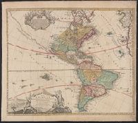
America occidentalium indiarum nomine Vulgo celebratissima non i[m]merito Europa Nova appellari posset
Description:
1st state, with California shown as a peninsula., Appears in Homann's Atlas novus., Imperfect: upper right corner mutilated, with some loss of text. Sheet measures 51.6 x 58.9 cm. Ms. note on verso: 6. Cross Collection no. 128., Prime meridian: Teneriffe., and Relief shown pictorially.
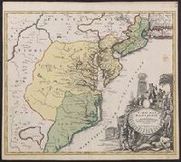
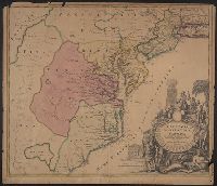
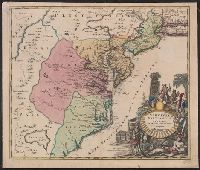
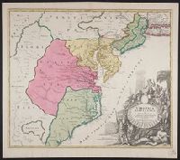
Also covers Delaware, southern Pennsylvania, New Jersey, western Long Island, southwestern Connecticut, and portions of adjacent areas., Bar scale given in "milliaria Germanica"., First appe, Includes ill., and Relief shown pictorially. Depths shown by soundings.
Also covers Delaware, southern Pennsylvania, New Jersey, western Long Island, southwestern Connecticut, and portions of adjacent areas., Bar scale given in "milliaria Germanica"., Includes ill., Relief shown pictorially. Depths shown by soundings., and Title in L
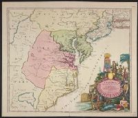
Also covers Delaware, southern Pennsylvania, New Jersey, western Long Island, southwestern Connecticut, and portions of adjacent areas., Bar scale given in "milliaria Germanica"., Includes ill., Prime meri, and Relief shown pictorially. Depths shown by soundings.
"Cum privilegio sac. caes. majest.", Also covers Delaware, southern P, Annotated "Quacker" near Philadelphia in red ink, and "100" in black ink on verso., Prime meridian: Ferro., Title in Latin. Place names in Latin, English, and French., and Watermark.
Guessefeld, F. L. (Franz Ludwig), 1744-1807 Harenberg, Johann Christoph, 1696-1774 Hase, Johann Matthias, 1684-1742 Homann Erben (Firm) Homann, Johann Baptist, 1663-1724 Lopez, D. T. Mayer, Tobias, 1723-1762 Rizzi-Zannoni, Giovanni Antonio, 1736-1814 Sperges, Joseph, Freiherr von, 1725-1791
Published / Created:
[1710-1786]
Call Number:
1983 Folio 23
Image Count:
2
Abstract:
A collection of maps issued by the Johann Baptist Homann or the Homann Erben firm between 1710 and 1786, made by various cartographers besides the Homann and the Homann Erben firm.