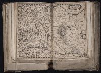
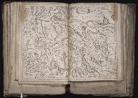
[Atlas factice of 96 maps by Blaeu, Visscher, Jansson, Hondius and others]
Image Count:
1
Description:
Imperfect: tear along fold, with some loss of text. Reinforced along lower edges with manuscript waste. Sheet measures 39.1 x 51.2 cm. No. 55 of 92 maps bound together.
Publisher:
Excudit Guiljelmus Blaeuw
Subject (Geographic):
Utrecht (Netherlands : Province) --Maps --Early works to 1800
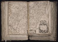
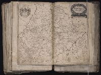
[Atlas factice of 96 maps by Blaeu, Visscher, Jansson, Hondius and others]
Image Count:
1
Description:
Imperfect: mutilated along fold and in upper right, with some loss of text. Reinforced along edges with manuscript waste. Sheet measures 39 x 50.1 cm. No. 29 of 92 maps bound together.
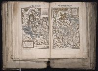
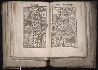
[Atlas factice of 96 maps by Blaeu, Visscher, Jansson, Hondius and others]
Image Count:
1
Description:
Each map hand col. Sheet measures 38.8 x 48 cm. Reinforced along edges with manuscript waste. No. 46 of 92 maps bound together. and Numbered 50 on verso.
Publisher:
Christoffel Froschauer
Subject (Geographic):
Zurich (Switzerland : Canton) --Maps --Early works to 1800
Froschauer, Christoph, d. 1564, printer Stumpf, Johannes, 1500-1576?
Published / Created:
[ca. 1556?]
Call Number:
1983 Folio 19
Collection Title:
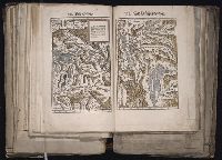
[Atlas factice of 96 maps by Blaeu, Visscher, Jansson, Hondius and others]
Image Count:
1
Description:
Each map hand col. Sheet measures 38.5 x 47.9 cm. Reinforced along edges with manuscript waste. No. 47 of 92 maps bound together. and Numbered 51 on verso.
Blanks not scanned., Imperfect, wanting 16 plates and 1 map., Order of plates does not follow that of descriptions in vol. 1., Some plates are numbered, some plates are unnumbered and interspersed. Two possible arrangements outlined in v. 1 which these seem not to follow closely. With the exception of the port. of Selim III (frontis. of text vol.), all other plates including the 2 remaining maps are bound together., and Two plates trimmed and laid in loose.
Publisher:
Chez les editeurs ... ; De l’Imprimerie de P. Didot, l’aine, M.DCCCXIX
Subject (Geographic):
Bosporus (Turkey) --Pictorial works, Istanbul (Turkey) --Description and travel, Istanbul (Turkey) --Pictorial works, Marmara, Sea of (Turkey), Turkey --Court and courtiers --Clothing --Pictorial works, Turkey --French influences, and Turkey --History --Ottoman Empire, 1288-1918 --Pictorial works
Subject (Name):
Desmaisons, 1780-1834?,
Kauffer, Francois,
Leve, Mlle.,
Michel, F. P., Barbie du Bocage, Jean Denis, 1760-1825, Bovinet, Edme, 1767-1832, Cardano, Jose´ Maria, Coiny, Jacques Joseph, 1761-1809, Dequevauviller, Francois-Nicolas-Barth elemy, 1745-1807, Desaulx, Jean, Duparc, Marie-Alexandre, Duplessi-Bertaux, Jean, 1750-1818, Hadice, Sultan, sister of Selim III, Sultan of the Turks, 1762- --Palaces --Pictorial works, Lacretelle, Charles, 1766-1855, Le Gouaz, Yves Marie, 1742-1816, Le Rouge, Jean-Nicolas, b. ca. 1776, Marillier, Clement Pierre, 1740-1808, Melling, Antoine Ignace, 1763-1831, Nee, Francois Denis, 1732-1817, Pigeot, Francois, 1775-after 1834, Pillemont, Victor, 1767-1814, Queverdo, Louis-Marie-Yves, 1788-, Reville, Jean Baptiste, 1767-1825, Schroeder, Friedrich, 1768-1839, and Selim III, Sultan of the Turks, 1761-1808 --Homes and haunts --Pictorial works
Map of San Francisco imperfect: torn along fold at upper right., Maps linen backed and bound in on tabs., Numerous pagination errors., and Printer’s dummy[?] with printed title page and "avant propos." Text consists of mounted newspaper clippings[?] and original illustrations in pencil and watercolor as well as several prints (from other sources) and two hand drawn and colored maps of San Francisco and Northern California.
Publisher:
Imp. Comm. (Margritat G., Dr)
Subject (Geographic):
California--Maps, Manuscript and San Francisco (Calif.)--Maps, Manuscript
Subject (Topic):
California --Gold discoveries and Voyages to the Pacific coast
[Atlas factice of 96 maps by Blaeu, Visscher, Jansson, Hondius and others]
Image Count:
1
Description:
Imperfect: cartouche cut out and replaced in ms. with title Wurtemberg Ducatus; edges reinforced with ms waste. Sheet measures 38.5 x 48.9 cm. No. 68 of 92 maps bound together. and Numbered 73 on verso.
Publisher:
Willem Janszoon Blaeu
Subject (Geographic):
Wurttemberg-Baden (Germany) --Maps --Early works to 1800
Froschauer, Christoph, d. 1564, printer Stumpf, Johannes, 1500-1576?
Published / Created:
[ca. 1556?]
Call Number:
1983 Folio 19
Collection Title:
[Atlas factice of 96 maps by Blaeu, Visscher, Jansson, Hondius and others]
Image Count:
1
Description:
Each map hand col. Sheet measures 38.8 x 47.5 cm. Reinforced along edges with manuscript waste. No. 49 of 92 maps bound together. and Numbered 52 on verso.
Publisher:
Christoffel Froschauer
Subject (Geographic):
Basel (Canton) (Switzerland) --Maps--Early works to 1800 and Valais (Switzerland)--Maps--Early works to 1800