Skip to search
Skip to main content
Skip to first result
Search
You Searched For
Extent of Digitization
Completely digitized
Genre
Maps
Subject (Name)
Roeser, C. (Charles)
New Search
Search Results
Creator:
Call Number:
833 1879
Container / Volume:
BRBL_00584
Image Count:
1
Resource Type:
Maps, Atlases & Globes
Description:
"J.A. Williamson, Commissioner, Department of the Interior, General Land Office.", Gives longitude west from Greenwich and Washington., and Relief shown by hachures.
Publisher:
General Land Office, 1879 and Julius Bien, Photo lith & print.)
Subject (Geographic):
Wyoming--Maps
Subject (Name):
Bien, Julius, 1826-1909 and Roeser, C. (Charles)
Found in:
Beinecke Rare Book and Manuscript Library > Territory of Wyoming : 1879 / compiled from the official records of the General Land Office and other sources by C. Roeser, Principal Draughtsman, G.L.O.
Creator:
Published / Created:
1879
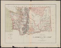
Call Number:
847 1879
Container / Volume:
BRBL_00625
Image Count:
1
Resource Type:
Maps, Atlases & Globes
Description:
"J.A. Williamson, Commissioner" General Land Office., "Longitude west from Greenwich and Washington.", and Relief shown by hachures.
Publisher:
The Office,
Subject (Geographic):
Washington (State)--Maps
Subject (Name):
Bien, Julius, 1826-1909 and Roeser, C. (Charles)
Found in:
Beinecke Rare Book and Manuscript Library > Washington Territory / compiled from the official records of the General Land Office and other sources by C. Roeser, Principal Draughtsman, General Land Office.
Branch:v1.61.8 ,Deployed:2024-06-20T11:14:55-04:00