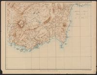
Carte de la partie occidentale de l 'Asie mineure and Map of the western part of Asia Minor
Description:
Covers western Anatolia and islands in Aegean Sea., Map in German; title in German, French, and English., Relief shown by shading and spot heights., and Sheet XV. only
Publisher:
Verlag von Dietrich Reimer,
Subject (Geographic):
Aegean Islands (Greece and Turkey)--Maps and Turkey--Maps
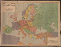
"Berliner Lithographisches, Institut Julius Moser.", "Supplement no. 2, January issue, 1921, 'The Transatlantic Trade, ' published by the American Chamber of Commerce, Berlin.", and "The boundaries of Germany, German-Austria, Bulgaria and Turkey have been adjus
Publisher:
GEA Verlag, Berlin,
Subject (Geographic):
Europe--Maps and Germany--Maps
Subject (Name):
American Chamber of Commerce in Germany and Institut Julius Moser
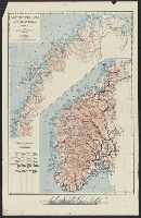
Includes text in German and English protesting the proposed boundaries of Czechoslovakia as infringing upon ethnically German, Slovakian and Polish territories.
Publisher:
L.V. Enders'schen K.-A.,
Subject (Geographic):
Czech Republic--Boundaries--Germany--Maps and Germany--Boundaries--Czech Republic--Maps
Subject (Topic):
Germans--Czech Republic--Bohemia--Maps, Germans--Czech Republic--Sudetenland--Maps, and World War, 1914-1918--Territorial questions--Maps
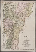
"Zu Ebelings Erdbeschr, Also shows county boundaries., In upper right margin: No. XVI., Place names in German and English., Prime meridians: Greenwich and Washington., Relief shown by hachures., and Sheet measures 72.4 x 50.5 cm. Franklin Collection no. 131 1796 1.
Publisher:
Bey Carl Ernst Bohn,
Subject (Geographic):
Vermont--Administrative and political divisions--Maps--Early works to 1800 and Vermont--Maps--Early works to 1800
Subject (Name):
Bohn, Carl Ernst, publisher, Ebeling, Christophe Daniel, 1741-1817. Erdbeschreibung und Geschichte von Amerika, and Schmidt, Paulus, engraver
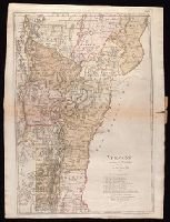
"Zu Ebelings Erdbeschreibung von Amerika.", Also shows county boundaries., In upper right margin: No. XVI., Place names in German and English., Prime meridians: Greenwich and Washington., Relief shown by hachures., and Sheet measures 74.9 x 54.1 cm. Ms. no.: L.C. 9
Bohn, Carl Ernst, publisher Ebeling, Christophe Daniel, 1741-1817. Erdbeschreibung und Geschichte von Amerika Schmidt, Paulus, engraver Sotzmann, D. F
Published / Created:
1796
Call Number:
1977 Folio 177
Image Count:
2
Resource Type:
Maps, Atlases & Globes
Description:
"Zu Ebelings Erdbeschreibung von Amerika.", Also shows county boundaries., Bar scales given in "Geographische Meilen 15 auf einen Grad" and "Englische meilen 69 4/25 auf einen Grad.", In upper right margin: No. XVI., Place names in German and English., Prime meridians: Greenwich and Washington., Relief shown by hachures., Sheet measures 72.8 x 54.3 cm. No. 10 of 34 maps bound together., and Watermark.
Publisher:
Bey Carl Ernst Bohn,
Subject (Geographic):
Vermont--Administrative and political divisions--Maps--Early works to 1800 and Vermont--Maps--Early works to 1800