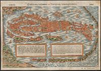
Contrafhetung der fuernemen statt Venedig sampt den umbligenden inseln
Description:
Bird's-eye view., From Münster's Cosmographei [Basel : Heinrich Petri, 1550], pp. 187-190., German, Latin., Pg. nos. on recto: 188, 189. Pg. nos. on verso: 187, 190., Relief shown pictorially., and Signature on recto: Q iii. Signature on verso: Q ii.
Publisher:
Heinrich Petri,
Subject (Geographic):
Venice (Italy)--Maps--Early works to 1800
Subject (Name):
Münster, Sebastian, 1489-1552. Cosmographei. German and Petri, Heinrich, 1508-1579
"DK," the initials of woodcutter David Kandel, appear in lower left-hand corner., Imperfect: torn along center fold, with some loss of text. Cross collection no. 5., and Map depicts the continents of Africa, Asia, Europe ("Europa"), and the New World, the coat of arms of Castile and León, sailing vessels, sea monsters, and twelve wind heads.
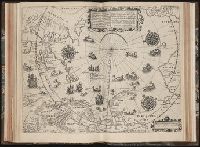
Tertia pars Indiae Orientalis ... / de Germanico in Latinum translata, & bono ordine disposita a
Image Count:
1
Description:
In pencil on verso: Part 3 p 132.
Subject (Geographic):
Arctic Ocean --Maps, Arctic regions --Discovery and exploration --Maps --Early works to 1800, Finland --Maps --Early works to 1800, Norway --Maps, and Sweden --Maps
Collection Created:
Francofurti : Excudebat Matthaeus Beckerus, anno MDCI [1601]
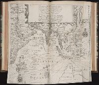
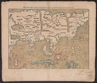
Laender Asie nach ihrer Gelegenheit biβ in Indiam, werden in dieser Tafeln verzeichnet
Description:
Appears in the author's Cosmographia., German, Latin., Hand col. Sheet measures 35 x 40 cm. Lanman Collection., Text, ill., "xxiiij" on verso., and Title on verso: India neuw.
Publisher:
H. Petri,
Subject (Geographic):
Asia--Maps--Early works to 1800
Subject (Name):
Münster, Sebastian, 1489-1552. Cosmographia and Petri, Heinrich, 1508-1579
Cross Collection no. 245., Imperfect: map of Jamaica cut-out. Two maps (Antigua and Barbados)., Includes explanatory notes and index., Relief shown pictorially., Scales in millaria Anglica communia and/or millaria Anglica statuta., and Sheet title in Latin and German. Individual map titles and text in German. Maps in English and German.
Publisher:
Homann Erben,
Subject (Geographic):
Antigua--Maps--Early works to 1800, B, Barbados--Maps--Early works to 1800, Jamaica--Maps--Early works to 1800, Saint Kitts and Nevis--Maps--Early works to 1800, and West Indies--Maps--Early works to 1800