Skip to search
Skip to main content
Skip to first result
Search
You Searched For
Format
cartographic
Language
German
Language
Latin
New Search
Search Results
Creator:
Published / Created:
1737?]
Call Number:
85 1759
Container / Volume:
BRBL_00693
Image Count:
1
Resource Type:
Maps, Atlases & Globes
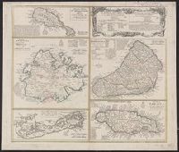
Description:
Cross Collection no. 253., Includes explanatory notes and index., Ms. notes in upper right corner., Relief shown pictorially., Scales in millaria Anglica communia and/or millaria Anglica statuta., Sheet title in Latin and German. Individual map titles and text in German. Maps in English and German., and Three maps (Antigua, Barbados, Jamaica). Mounted on linen.
Publisher:
Homann Erben,
Subject (Geographic):
Antigua--Maps--Early works to 1800, Barbados--Maps--Early works to 1800, Bermuda Islands--Maps--Early works to 1800, Jamaica--Maps--Early works to 1800, and Saint Kitts and Nevis--Maps--Early works to 1800
Found in:
Beinecke Rare Book and Manuscript Library > Dominia anglorum in praecipuis insulis Americae ut sunt insula : S. Christophori, Antegoa, Iamaica, Barbados, nec non insulae Bermudes vel Sommers dictae, singulari mappa omnia a exhibita et edita ab Homannianis Heredibus = Die englische Colonie-Laender a
Creator:
Published / Created:
ca. 1750
Call Number:
1973 Folio 30
Collection Title:
[Atlas factice of 32 maps and 1 distance table, produced by the Homann Erben firm]
Image Count:
2
Publisher:
[Tobias Conrad Lotter?]
Subject (Geographic):
Chemnitz (Germany : Landkreis) --Maps --Early works to 1800 and Zwickau (Germany : Landkreis) --Maps --Early works to 1800
Subject (Topic):
Atlases, German --Early works to 1800
Collection Created:
[Nuremberg : s.n., 1701-1760]
Found in:
Beinecke Rare Book and Manuscript Library > Dynastiae comitat[us] Schoenbuirgici Penig, Remissa, Rochsburg, Wechselburg [cartographic material] : in clientela Elect. Saxon Glaucha, Hartenstein, Lichtenst. Stein, Waldenburg Praedia Benefic. S.R. Imp. ad circulum S.R.I. Saxoniae superiorem pertinente
Creator:
Published / Created:
ca. 1757
Call Number:
1973 Folio 30
Collection Title:
[Atlas factice of 32 maps and 1 distance table, produced by the Homann Erben firm]
Image Count:
2
Publisher:
[Tobias Conrad Lotter]
Subject (Geographic):
Saxony (Germany) --Maps --Early works to 1800
Subject (Topic):
Atlases, German --Early works to 1800
Collection Created:
[Nuremberg : s.n., 1701-1760]
Found in:
Beinecke Rare Book and Manuscript Library > Electoratus Saxonici Praefecturae Annaburgensis, Pretzschens[is] Torgaviensis, Schweinicensis, Muehlbergensis studio geographico / [cartographic material] / ita depictae, ut urbes, oppida, vici, pagi, aedes solitar cum vicinia accurate distingui possint a
Creator:
Published / Created:
[ca. 1758]
Call Number:
1973 Folio 30
Collection Title:
[Atlas factice of 32 maps and 1 distance table, produced by the Homann Erben firm]
Image Count:
2
Publisher:
Anjezo im Verlag bey Tobias Conrad Lotter, Geogr. ...
Subject (Geographic):
Saxony-Anhalt (Germany) --Maps --Early works to 1800
Subject (Topic):
Atlases, German --Early works to 1800
Collection Created:
[Nuremberg : s.n., 1701-1760]
Found in:
Beinecke Rare Book and Manuscript Library > Episcopatus Numburgensis et cizensis delineatio geographica adjectis praefecturis Portensi, Pegaviensi, Tautenburg et finitimis / [cartographic material] / cura Matth. Seutteri Geogr. Caes
Creator:
Published / Created:
1544]
Call Number:
30 1544
Container / Volume:
BRBL_00732
Image Count:
2
Resource Type:
Maps, Atlases & Globes
Description:
From Münster's Cosmographia., Hand col. Sheet measures 34.5 x 40 cm. Lanman Collection., Oriented with north to the bottom., Recto: German, Latin. Verso: German., Relief shown pictorially., Text, ill., "iii" on verso., and Title on verso: Neüw Europa.
Publisher:
Heinrich Petri,
Subject (Geographic):
Europe--Maps--Early works to 1800
Subject (Name):
Münster, Sebastian, 1489-1552. Cosmographia and Petri, Heinrich, 1508-1579, publisher
Found in:
Beinecke Rare Book and Manuscript Library > Europa, das ein Drittheil der Erden nach Gelegenheit unsern Zeiten.
Creator:
Published / Created:
1879
Call Number:
5 1550
Container / Volume:
BRBL_00271
Image Count:
1
Resource Type:
Maps, Atlases & Globes
Description:
Reproduction of gores for a 17 cm globe.
Publisher:
[publisher not identified],
Subject (Name):
Austro-Hungarian Monarchy. Militär-Comité.
Subject (Topic):
Astronomy--Study and teaching--Early works to 1800--Facsimiles., Celestial globes--Early works to 1800--Facsimiles., Globes--Early works to 1800--Facsimiles., and Navigation--Study and teaching--Early works to 1800--Facsimiles
Found in:
Beinecke Rare Book and Manuscript Library > Globus aus der Mitte des XVI Jahrhunderts.
Published / Created:
MDCI [1601]
Call Number:
Taylor 193 3
Collection Title:
Tertia pars Indiae Orientalis ... / de Germanico in Latinum translata, & bono ordine disposita a
Image Count:
1
Description:
In pencil: Part 3. 31.
Subject (Geographic):
Saint Helena Island (S.C.)
Collection Created:
Francofurti : Excudebat Matthaeus Beckerus, anno MDCI [1601]
Found in:
Beinecke Rare Book and Manuscript Library > Insula D. Helenae ...
Branch:v1.61.8 ,Deployed:2024-06-20T11:14:48-04:00