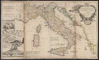
"Note: the post roads in this map are taken from Iacobo Cantelli da Vignola the Duke of Modena's geographer.", *40 1714: verso: stamped "Yale UL"; dgvmp2008., and Includes inset views of Caesium, Vesuvius, Aetna.
Publisher:
printed for H. Moll...Ino. Bowles...T. Bowles...Philip Overton,
Subject (Geographic):
Italy--Maps--Early works to 1800 and Mediterranean Region--Maps--Early works to 1800
Subject (Name):
Bowles, John, 1701-1779, Bowles, Thomas, -1767, Cantelli da Vignola, Giacomo, 1643-1719, and Overton, Philip, -1751
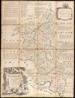
Dedicated to Charles, Duke of Marlborough., Imperfect: trimmed along outside graticule, with some loss of text. Dissected and mounted on linen., Includes notes about the county and shows boundaries, roads, parks and settlements., Plate 6 from: The large English atlas, or, A new set of maps of all the counties in England and Wales / Emanuel Bowen. London: Printed and sold by Robert Wilkinson, at No. 58, in Cornhill, successor to Mr John Bowles, deceased, [1785]., Prime meridian: London., and Relief shown pictorially.
Publisher:
Printed for R. Sayer at the Golden Buck in Fleet Street, John Bowles at the Black Horse in Cornhil, and Carrington Bowles in St. Pauls Church Yard,
Subject (Geographic):
Buckinghamshire (England)--Maps--Early works to 1800.
Subject (Name):
Bowen, Emanuel, 1693 or 1694-1767. Large English atlas, or, A new set of maps of all the counties in England and Wales., Bowles, Carington, 1724-1793, Bowles, John, 1701-1779, and Sayer, Robert, 1725-1794
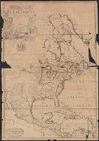
Dates inferred from similarity to variants dated c.1750 and c.1760 in Tooley's Mapping of America, p. 47 and 91., Includes text and ill., Relief shown pictorially., and Yale's copy 1 stamped on verso, "Yale, Horace Brown, 1900S." Copy 2 torn in 2 sheets, 47 x 68
Publisher:
John Bowles and Son in Cornhil :, printed for T. Bowles in St. Pauls Church yard :, and Robt. Sayer in Fleet Street,
Subject (Geographic):
North America--Maps--Early works to 1800
Subject (Name):
Bowles, John, 1701-1779, Bowles, Thomas, -1767, and Sayer, Robert, 1725-1794