Search
You Searched For
Search Results
- Published / Created:
- 1765
- Call Number:
- 771 Al13 1765
- Container / Volume:
- BRBL_00713
- Image Count:
- 2
- Resource Type:
- Maps, Atlases & Globes
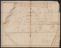
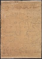
- Description:
- Clipping from revolutionary war period manuscript New York maps. and Color: pen and ink drawing.
- Subject (Geographic):
- Albany (N.Y.)--Maps, Manuscript--Early works to 1800
- Found in:
- Beinecke Rare Book and Manuscript Library > A Map of the Lands on the Southside of the County of Albany between the Blue Mountains and the Sawkill. Surred in the month of Oct. 1765, by Will Cockburn.
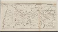
- Published / Created:
- [1785?]
- Call Number:
- 755 1785F
- Container / Volume:
- BRBL_00435
- Image Count:
- 1
- Resource Type:
- Maps, Atlases & Globes
- Description:
- Mounted.
- Publisher:
- Engraved and Printed by John Fitch,
- Subject (Geographic):
- East (U.S.)--Maps--Early works to 1800
- Found in:
- Beinecke Rare Book and Manuscript Library > A Map of the North West parts of the United States of America ... [by] John Fitch ...
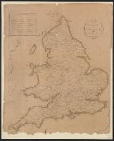
- Published / Created:
- [1790?]
- Call Number:
- 32 1790
- Container / Volume:
- BRBL_00044
- Image Count:
- 1
- Resource Type:
- Maps, Atlases & Globes
- Publisher:
- P. Wogan,
- Subject (Geographic):
- England--Maps--Early works to 1800
- Found in:
- Beinecke Rare Book and Manuscript Library > A Map of the Roads of England and Wales.
- Published / Created:
- [1795]
- Call Number:
- 801 1795
- Container / Volume:
- BRBL_00541
- Image Count:
- 1
- Resource Type:
- Maps, Atlases & Globes
- Description:
- Engraved for Carey's American Edition of Guthrie's Geography Improved. and J.T. Scott Sculp.
- Subject (Geographic):
- Tennessee--Maps--Early works to 1800
- Found in:
- Beinecke Rare Book and Manuscript Library > A Map of the Tennassee State formerly Part of North Carolina taken Chiefly from Survey by Genl. Smith & others.
- Published / Created:
- [1831?]
- Call Number:
- 764 B63 1831
- Container / Volume:
- BRBL_00454
- Image Count:
- 1
- Resource Type:
- Maps, Atlases & Globes
- Publisher:
- Pendleton Lithography,
- Subject (Geographic):
- Bolton (Mass. : Town)--Maps
- Found in:
- Beinecke Rare Book and Manuscript Library > A Map of the Town of Bolton in the County of Worcester and the Commonwealth of Massachusetts. Surveyed by Silas Holman in the Year 1831.
- Published / Created:
- 1783
- Call Number:
- Cb21 35B
- Collection Title:
- History of the war with America, France, Spain, and Holland; commencing in 1775 and ending in 1783
- Image Count:
- 1
- Description:
- Preceding title page. and Teaching resource: Professor John Mack Faragher, History 141: The American West.
- Publisher:
- I. Fielding
- Subject (Geographic):
- Great Britain --History --1760-1789, United States --History --Revolution, 1775-1783, and United States --Maps --Early works to 1800
- Collection Created:
- London, J. Fielding, 1785-86
- Found in:
- Beinecke Rare Book and Manuscript Library > A Map of the United States of America, as settled by the peace of 1783
- Published / Created:
- 1809
- Call Number:
- 755 1809A
- Container / Volume:
- BRBL_00438
- Image Count:
- 1
- Resource Type:
- Maps, Atlases & Globes
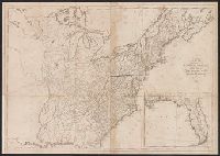
- Description:
- Inset: Florida.
- Publisher:
- Engraved for and sold by Matthew Carey,
- Subject (Geographic):
- Canada--Maps and East (U.S.)--Maps
- Found in:
- Beinecke Rare Book and Manuscript Library > A Map of the United States: compiled chiefly from the State Maps, and other Authentic Information, by Saml. Lewis.
- Published / Created:
- 1795
- Call Number:
- 11 1795
- Container / Volume:
- BRBL_00006
- Image Count:
- 1
- Resource Type:
- Maps, Atlases & Globes
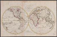
- Description:
- From Carey's American Edition of Guthrie's Geography Improved.
- Publisher:
- Mathew Carey,
- Subject (Geographic):
- World--Maps--Early works to 1800
- Found in:
- Beinecke Rare Book and Manuscript Library > A Map of the World from the best Authorities.
- Call Number:
- Zd 147
- Collection Title:
- The history of the Five Indian nations of Canada : which are dependent on the province of New-York
- Image Count:
- 1
- Description:
- Preceding title page. and Teaching resource: Professor John Mack Faragher, History 141: The American West.
- Subject (Geographic):
- New York (State) --History --Colonial period, ca. 1600-1775 and Pennsylvania --History --Colonial period, ca. 1600-1775
- Subject (Name):
- Osborne, Thomas, d. 1767, bookseller
- Subject (Topic):
- Indians of North America --Early works to 1800 and Iroquois Indians --Early works to 1800
- Collection Created:
- London : Printed for T. Osborne, in Gray's-Inn, MDCCXLVII [1747]
- Found in:
- Beinecke Rare Book and Manuscript Library > A Map of the country of the Five Nations, belonging to the province of New York; and of the lakes near which the nations of far Indians live, with part of Canada