- Creator:
- Homann, Johann Baptist, 1663-1724
- Published / Created:
- between 1730 and 1763?]
- Call Number:
- 71 1730
- Container / Volume:
- BRBL_00362
- Image Count:
- 1
- Resource Type:
- Maps, Atlases & Globes
- Description:
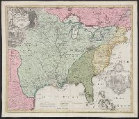
- Appears in Homann Erben's Atlas geographicus major [1759 or 1763?]., Includes ill. and text., Relief shown pictorially., Some text in French., and Yale's card catalog notes "Fock catalogue no. 731 (fr. wh. acquired) gives date as ca. 1730"; and "In Homann J.B. Ne
- Publisher:
- [Homannianis heredibus?,
- Subject (Geographic):
- Louisiana--Maps--Early works to 1800 and North America--Maps--Early works to 1800
- Subject (Name):
- Hennepin, Louis, 17th cent and Homann Erben (Firm). Atlas geographicvs maior
- Found in:
- Beinecke Rare Book and Manuscript Library > Amplissimae regionis Mississipi seu Provinciae Ludovicianae : â R.P. Ludovico Hennepin Francisc. Miss. in America Septentrionali anno 1687 detectae. nunc Gallorum Coloniis et actionum negotiis toto orbe celeberrimae, nova tabula / edita à Io. Bapt. Homa
Search
Limit your search
- Maps1
- Homann, Johann Baptist, 1663-1724✖[remove]1
- Hennepin, Louis, 17th cent1
- Homann Erben (Firm). Atlas geographicvs maior✖[remove]1
Current results range from 1730 to 1763