Skip to search
Skip to main content
Skip to first result
Search
You Searched For
Extent of Digitization
Completely digitized
Language
Latin
New Search
Search Results
Creator:
Published / Created:
1734?]
Call Number:
71 1750C
Container / Volume:
BRBL_00362
Image Count:
1
Resource Type:
Maps, Atlases & Globes
Description:
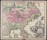
Appears in the author's Grosser atlas ... [between 1734 and 1750?], Covers North America from Quebec to the Gulf of Mexico, and to New Mexico in the west., In French, with title in Latin., and Includes decorative cartouche, historical notes and inset of "Les cos
Publisher:
s.n. ,
Subject (Geographic):
North America--Maps--Early works to 1800
Subject (Name):
Rein, Melchior, Rogg, Gottfried, 1669-1742, and Seutter, Matthaeus, 1678-1756. Grosser atlas
Found in:
Beinecke Rare Book and Manuscript Library > Accurata delineatio celeberrimae regionis Ludovicianae vel Gallice Louisiane ot. Canadae et Floridae adpellatione in Septemtrionali America : descriptae quae hodie nomine fluminis Mississippi vel St. Louis per colonias et navigationes Gallorum ob immensas
Published / Created:
1730?]
Call Number:
71 1730B
Container / Volume:
BRBL_00725
Image Count:
1
Resource Type:
Maps, Atlases & Globes
Description:
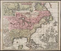
"Gottfr. Rogg del. ; M. Rhein sc.", Franklin Collection no. 131 173-?., and Inset: "Les costes de la Louisiane ... "
Subject (Geographic):
France--Colonies--America--Maps--Early works to 1800 and North America--Maps--Early works to 1800
Found in:
Beinecke Rare Book and Manuscript Library > Accurata delineatio celeberrimæ regionis Ludovicianæ vel gallice Louisiane ... in lucem edita cura et manu Matthæi Seutteri ...
Published / Created:
[1780?]
Call Number:
39 1780
Container / Volume:
BRBL_00185
Image Count:
1
Resource Type:
Maps, Atlases & Globes
Subject (Geographic):
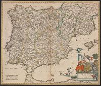
Spain--Maps--Early works to 1800
Found in:
Beinecke Rare Book and Manuscript Library > Accuratis sima Totius Regni Hispaniae tabula Per Gerardum a Schagen.
Creator:
Published / Created:
[1638]
Call Number:
911 1630
Container / Volume:
BRBL_00699
Image Count:
2
Resource Type:
Maps, Atlases & Globes
Alternative Title:
Baya de todos os Sanctos. and Villa d'Olinda de Pernambuco.
Description:
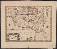
Bar scales in "Milliaria Germanica communia" and "Milliaria Gallica communia.", Cross Collection no. 339., From Hondius's Atlantis novi ... [Amsterdam] : Sumptibus & typis aeneis Henrici Hondij ..., 1638., Hand col., In Latin on verso, with caption title "Brasilia" and signature 5B., Insets: [1] Baya de todos os Sanctos -- [2] Villa d'Olinda de Pernambuco., Oriented with north to the right., Relief shown pictorially., and Shows the coast of Brazil from San Marcos bay to modern Curityba.
Publisher:
Henricus Hondius excudit,
Subject (Geographic):
Brazil--Maps--Early works to 1800
Subject (Name):
Hondius, Hendrik, 1597-1651. Atlas novus
Found in:
Beinecke Rare Book and Manuscript Library > Accuratissima Brasiliae tabula.
Creator:
Published / Created:
[ca. 1647]
Call Number:
911 1652
Container / Volume:
BRBL_00668
Image Count:
2
Resource Type:
Maps, Atlases & Globes
Alternative Title:
Baya de todos os Sanctos. and Villa d'Olinda de Pernambuco.
Description:
Bar scales in "Milliaria Germanica communia" and "Milliaria Gallica communia.", From Jansson's Nieuwen atlas ... Amstelodami : Apud Ioannem Ianssonium, 1647., Hand col. Sheet measures 50.1 x 60.6 cm., Insets: [1] Baya de todos os Sanctos -- [2] Villa d'Olinda de Pernambuco., Oriented with north to the right., Relief shown pictorially., and Shows the coast of Brazil from San Marcos bay to modern Curityba.
Publisher:
Joannes Janssonius excudit,
Subject (Geographic):
Brazil--Maps--Early works to 1800
Subject (Name):
Jansson, Jan, 1588-1664. Novus atlas. Dutch
Found in:
Beinecke Rare Book and Manuscript Library > Accuratissima Brasiliae tabula.
Published / Created:
[1700?]
Call Number:
38 1700
Container / Volume:
BRBL_00151
Image Count:
1
Resource Type:
Maps, Atlases & Globes
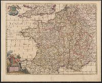
Subject (Geographic):
France--Maps--Early works to 1800
Found in:
Beinecke Rare Book and Manuscript Library > Accuratissima Galliae Tabula Vulgo Rogaume de France Per Joannem de Ram.
Published / Created:
[1660?]
Call Number:
3615 1660
Container / Volume:
BRBL_00135
Image Count:
1
Resource Type:
Maps, Atlases & Globes
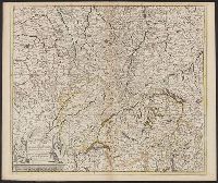
Description:
Includes Northeastern France, Switzerland, Southwestern Germany.
Publisher:
Per Theodorum Danckerum,
Subject (Geographic):
Rhine River--Maps--Early works to 1800
Found in:
Beinecke Rare Book and Manuscript Library > Accuratissima Rheni Superioris Mosae et Mosellae ...
Creator:
Published / Created:
ca. 1750
Call Number:
1973 Folio 30
Collection Title:
[Atlas factice of 32 maps and 1 distance table, produced by the Homann Erben firm]
Image Count:
2
Publisher:
[Matthaeus Seutter?]
Subject (Geographic):
Dresden (Germany : Regierungsbezirk) --Maps --Early works to 1800
Subject (Topic):
Atlases, German --Early works to 1800
Collection Created:
[Nuremberg : s.n., 1701-1760]
Found in:
Beinecke Rare Book and Manuscript Library > Accuratissima delineatio geographica dioecesis ac praefecturae Dresdensis [cartographic material] : cujus urbes, oppida et pagi, loca item contermina, et quae in singulis notatu digniora videntur exactiori methodo geometrice designata sistuntur / per Matt
Published / Created:
[1720?]
Call Number:
39 1720
Container / Volume:
BRBL_00185
Image Count:
1
Resource Type:
Maps, Atlases & Globes
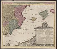
Subject (Geographic):
Spain--Maps--Early works to 1800
Found in:
Beinecke Rare Book and Manuscript Library > Accuratissima et Obres Billicas nunc denuo Revisa Tabula Regnorum, Valentiae et Murciae, insularum Mejorcae, Minorcae et Jvicae ... Osten duntur Auctore Luggardo Van Ansé Sculptore Amt. Batavo.
Creator:
Published / Created:
1700]
Call Number:
60 1700A
Container / Volume:
BRBL_00322
Image Count:
1
Resource Type:
Maps, Atlases & Globes
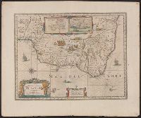
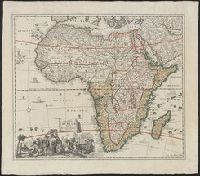
Alternative Title:
Africae tabula
Description:
Hand col. Sheet measures 58 x 66 cm., Includes ill. of ships and animals, and decorative cartouche., and Relief shown pictorially.
Publisher:
[s.n. ,
Subject (Geographic):
Africa--Maps--Early works to 1800
Subject (Name):
Homann, Johann Baptist, 1663-1724
Found in:
Beinecke Rare Book and Manuscript Library > Accuratissima totius Africae tabula / in lucem producta per Iacobum de Sandrart ; Joann. Bapt. Homann, sculpsit.
Branch:v1.61.6 ,Deployed:2024-06-12T09:55:19-04:00