
You Searched For
1 - 6 of 6
Search Results

- Creator:
- United States. War Department. Corps of Engineers, cartographer, publisher
- Published / Created:
- [1881]
- Call Number:
- 831 1881A
- Image Count:
- 2
- Resource Type:
- cartographic image
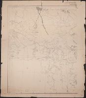
- Description:
- Relief shown by hachures., Scale "1 inch - 12 miles.", Shows battle sites and military expeditions, with dates., Westernmost sheet: "2nd edition May 1875 compiled under direction of Capt. Wm. Ludlow, Corps of Engrs."--Lower left margin., and In upper left margin: Brig. Genl. A.A. Humphreys, Chief of Engineers.
- Publisher:
- Corps of Engineers?
- Subject (Geographic):
- Montana
- Found in:
- Beinecke Rare Book and Manuscript Library > Montana Territory

- Creator:
- United States. War Department. Corps of Engineers, cartographer, publisher
- Published / Created:
- [1875?]
- Call Number:
- 831 1875
- Image Count:
- 1
- Resource Type:
- cartographic image
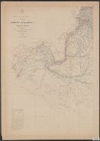
- Description:
- BEIN 831 1875: Imperfect: eastern sheet wanting; western sheet chipped. Inscription below edition statement: Lieut. [?] F. Eng., 5th Infty. Inscription on verso: Capt. Ludlow's map, 1875, sheet no. 1., Relief shown by hachures., Scale "1 inch - 12 miles.", Shows battle sites and military expeditions, with dates., and In upper left margin: Brig. Genl. A.A. Humphreys, Chief of Engineers.
- Publisher:
- Corps of Engineers?
- Subject (Geographic):
- Montana
- Found in:
- Beinecke Rare Book and Manuscript Library > Montana Territory

- Creator:
- United States. General Land Office
- Published / Created:
- [1908]
- Call Number:
- BrSides Zc35 908un
- Image Count:
- 2
- Resource Type:
- cartographic image
- Description:
- BEIN BrSides Zc35 908un: Holes punched in margins.
- Publisher:
- Dept. of the Interior, General Land Office, Andrew B. Graham Co.)
- Subject (Geographic):
- Cheyenne River Indian Reservation (S.D.), Standing Rock Indian Reservation (N.D. and S.D.), South Dakota, Cheyenne River Indian Reservation., United States, and Standing Rock Indian Reservation.
- Found in:
- Beinecke Rare Book and Manuscript Library > Sectionized map of Cheyenne River and Standing Rock Indian Reservation opened by act of May 29, 1908 [cartographic material]
- Creator:
- Maury, Matthew Fontaine, 1806-1873, cartographer
- Published / Created:
- 1847-1852.
- Call Number:
- Maury Charts 11cfk 1850A-4 1
- Image Count:
- 8
- Alternative Title:
- Maury's wind & current chart and Maury's wind and current chart
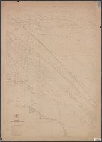
- Description:
- BEIN: 11cfk 1850A-4: Var. editions. 1 copy each of sheets 1-4 and sheets 5-8 mounted together on linen., Shows prevailing wind direction by month., Various eds. of some charts., Some sheets lack title and numberings., 1st and 2nd editions lack series designations A, B, C, etc., "The winds are denoted by small brushes, the head of the brush pointing to the direction whence the wind blows, the length of the brush shewing the comparative force.", "Eng. by Sherman & Smith N.Y."--Lower right margin on some sheets., "Series A.", Track chart, released as series A, a part of Maury's "Wind and current charts", series A-F. Covers the North Sea, the North Atlantic just west of the Hebrides, the Irish Sea, the English Channel, and the Bay of Biscay. The track charts were designed to illustrate the routes sailed by numerous Navy and merchant vessels. Directions of currents encountered and the force and direction of winds were included for each track. For complete discussion, see "The wind and current chart series produced by Matthew Fontaine Maury," by Marc I. Pinsel, in Navigation : Journal of the Institute of Navigation, v. 28, no. 2 (Summer, 1981), p. 123-137., Some sheets numbered individually in upper left margin, e.g.: 1, 2., On some sheets: Entered according to Act of Congress, in the year 1850, by M.F. Maury, in the Clerks office of the District Court of the southern district of New York., Accompanied by article from the magazine: Navigation : Journal of the Institute of Navigation. [16] leaves (p. 123-137) : photocopies ; 28 x 22 cm., Sheet no. 2 annotations in red ink., Copy imperfect: Sheets 1-2, 4 and torn and repaired along folid line. Sheet 2 covered in varnish. Sheets 1-3, 5-8 discoloration throughout, mounted on cloth backing., and Includes notes and printed track lines for numerous voyages of many different vessels on some sheets.
- Publisher:
- U.S. Hydrographical Office
- Subject (Geographic):
- North Atlantic Ocean. and North Atlantic Ocean
- Subject (Topic):
- Nautical charts, Winds, Ocean currents, Trade routes, Shipping, and Oceanography
- Found in:
- Beinecke Rare Book and Manuscript Library > Wind and current chart of the North Atlantic [cartographic material]
- Creator:
- Maury, Matthew Fontaine, 1806-1873, cartographer
- Published / Created:
- 1847-1852.
- Call Number:
- Maury Charts 11cfk 1850A-4 2
- Image Count:
- 5
- Alternative Title:
- Maury's wind & current chart and Maury's wind and current chart
- Description:
- BEIN: 11cfk 1850A-4: Var. editions. 1 copy each of sheets 1-4 and sheets 5-8 mounted together on linen., Shows prevailing wind direction by month., Various eds. of some charts., Some sheets lack title and numberings., 1st and 2nd editions lack series designations A, B, C, etc., "The winds are denoted by small brushes, the head of the brush pointing to the direction whence the wind blows, the length of the brush shewing the comparative force.", "Eng. by Sherman & Smith N.Y."--Lower right margin on some sheets., "Series A.", Track chart, released as series A, a part of Maury's "Wind and current charts", series A-F. Covers the North Sea, the North Atlantic just west of the Hebrides, the Irish Sea, the English Channel, and the Bay of Biscay. The track charts were designed to illustrate the routes sailed by numerous Navy and merchant vessels. Directions of currents encountered and the force and direction of winds were included for each track. For complete discussion, see "The wind and current chart series produced by Matthew Fontaine Maury," by Marc I. Pinsel, in Navigation : Journal of the Institute of Navigation, v. 28, no. 2 (Summer, 1981), p. 123-137., Some sheets numbered individually in upper left margin, e.g.: 1, 2., On some sheets: Entered according to Act of Congress, in the year 1850, by M.F. Maury, in the Clerks office of the District Court of the southern district of New York., Accompanied by article from the magazine: Navigation : Journal of the Institute of Navigation. [16] leaves (p. 123-137) : photocopies ; 28 x 22 cm., Sheet no. 2 annotations in red ink., Copy imperfect: Sheets 1-2, 4 and torn and repaired along folid line. Sheet 2 covered in varnish. Sheets 1-3, 5-8 discoloration throughout, mounted on cloth backing., and Includes notes and printed track lines for numerous voyages of many different vessels on some sheets.
- Publisher:
- U.S. Hydrographical Office
- Subject (Geographic):
- North Atlantic Ocean. and North Atlantic Ocean
- Subject (Topic):
- Nautical charts, Winds, Ocean currents, Trade routes, Shipping, and Oceanography
- Found in:
- Beinecke Rare Book and Manuscript Library > Wind and current chart of the North Atlantic [cartographic material]