Skip to search
Skip to main content
Skip to first result
Search
You Searched For
Access
Public
Genre
Engravings
New Search
Search Results
Creator:
Published / Created:
1776
Call Number:
Cb23 27
Collection Title:
The American military pocket atlas : being an approved collection of correct maps, both general and
Image Count:
1
Alternative Title:
The Seat of war, in the southern British colonies, comprehending North and South Carolina, Georgia, east and west Florida, &ca
Description:
15th Oct. 1776., Inset: Plan of Charlestown and plan of St. Augustine., and Teaching resource: Professor John Mack Faragher, History 141: The American West.
Publisher:
Printed for R. Sayer & J. Bennett, Map, Chart and Printsellers, No. 53 Fleet Street, as the Act directs
Subject (Geographic):
North America --Maps --Early works to 1800, Southern States --Maps --Early works to 1800, and United States --History --Revolution, 1775-1783 --Maps
Collection Created:
London : Printed for R. Sayer and J. Bennet, [1776]
Found in:
Beinecke Rare Book and Manuscript Library > A General map of the southern British colonies, in America, comprehending North and South Carolina, Georgia, east and west Florida, with the neighbouring Indian countries. From the modern surveys of engineer de Brahm, Capt. Collet, Mouzon & others; and from the large hydrographical survey of the coasts of east and west Florida
Published / Created:
Undated
Call Number:
CF2221 F74
Collection Title:
Relation du voyage de la Mer du Sud aux cotes du Chily et du Perou : fait pendant les annees 1712
Image Count:
1
Resource Type:
Books, Journals & Pamphlets
Alternative Title:
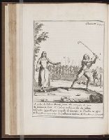
B Indienne en Choni and C Caliouin touhan ou fete des indiens ...
Subject (Geographic):
Chile
Subject (Topic):
Indians of South America
Collection Created:
Paris : J.G. Nyon, [etc.], 1716
Found in:
Beinecke Rare Book and Manuscript Library > A Indien du Chili en Macun jouant a la Sueca, jeu de croce
Published / Created:
Undated
Call Number:
CF2221 F74
Collection Title:
Relation du voyage de la Mer du Sud aux cotes du Chily et du Perou : fait pendant les annees 1712
Image Count:
1
Resource Type:
Books, Journals & Pamphlets
Alternative Title:
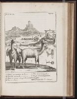
B Trapiche ou moulin a minerai and C Buiteron ou cour ou lon petri le minerai ...
Subject (Geographic):
Peru
Subject (Topic):
Indians of South America
Collection Created:
Paris : J.G. Nyon, [etc.], 1716
Found in:
Beinecke Rare Book and Manuscript Library > A Llamas ou moutons du Perou
Creator:
Published / Created:
1822
Call Number:
2003 Folio 81
Collection Title:
The New American Atlas ...
Container / Volume:
No. IV [4]
Image Count:
1
Description:
Already scanned for Mellon exhibit catalog, North America, S.W. sheet, and Printed by Wm. Duffee
Publisher:
H.S. Tanner
Subject (Geographic):
Mexico--Maps and North America--Maps
Collection Created:
Philadelphia : H.S. Tanner, 1822
Found in:
Beinecke Rare Book and Manuscript Library > A Map of North America, Constructed According to the Latest Information by H. S. Tanner
Creator:
Published / Created:
1800 Nov. 24
Call Number:
CF1921 E38 1801
Collection Title:
An historical survey of the island of Saint Domingo, together with an account of the Maroon negroes
Image Count:
1
Resource Type:
Maps, Atlases & Globes
Description:
Between p. 224-225.
Subject (Geographic):
Jamaica and West Indies
Subject (Topic):
Indians of the West Indies --Jamaica
Collection Created:
London,
Found in:
Beinecke Rare Book and Manuscript Library > A Map of the Island of St. Domingo
Published / Created:
1783
Call Number:
Cb21 35B
Collection Title:
History of the war with America, France, Spain, and Holland; commencing in 1775 and ending in 1783
Image Count:
1
Description:
Preceding title page. and Teaching resource: Professor John Mack Faragher, History 141: The American West.
Publisher:
I. Fielding
Subject (Geographic):
Great Britain --History --1760-1789, United States --History --Revolution, 1775-1783, and United States --Maps --Early works to 1800
Collection Created:
London, J. Fielding, 1785-86
Found in:
Beinecke Rare Book and Manuscript Library > A Map of the United States of America, as settled by the peace of 1783
Call Number:
Egf 789
Collection Title:
The American geography; or, A view of the present situation of the United States of America
Image Count:
1
Description:
Preceding p. 33.
Subject (Geographic):
France --History --Revolution, 1789-1799, United States --Description and travel, and United States --Maps --Early works to 1800
Subject (Topic):
Geography --Textbooks --Early works to 1800 and Maps --United States --1788
Collection Created:
Elizabeth Town : Printed by Shepard Kollock, for the author, M,DCC,LXXXIX
Found in:
Beinecke Rare Book and Manuscript Library > A Map of the northern and middle states; comprehending the western Territory and the British dominions in North America. Compiled from the best authorities
Creator:
Published / Created:
1788
Call Number:
Egf 789
Collection Title:
The American geography; or, A view of the present situation of the United States of America
Image Count:
1
Description:
Preceding p. 1.
Subject (Geographic):
France --History --Revolution, 1789-1799, United States --Description and travel, and United States --Maps --Early works to 1800
Subject (Topic):
Geography --Textbooks --Early works to 1800 and Maps --United States --1788
Collection Created:
Elizabeth Town : Printed by Shepard Kollock, for the author, M,DCC,LXXXIX
Found in:
Beinecke Rare Book and Manuscript Library > A Map of the states of Virginia, North Carolina South Carolina and Georgia comprehending the Spanish provinces of east and west Florida exhibiting the boundaries as fixed by the late Treaty of Peace between the United States and the Spanish dominions comp
Call Number:
Taylor 376
Collection Title:
The discoveries of John Lederer : in three several marches from Virginia, to the west of Carolina
Image Count:
1
Description:
Engraved by Cross. and Preceding title page.
Subject (Geographic):
North Carolina --Description and travel, North Carolina --Maps --Early works to 1800, Virginia --Description and travel, and Virginia --Maps --Early works to 1800
Subject (Name):
Talbot, William
Subject (Topic):
Indians of North America --North Carolina and Indians of North America --Virginia
Collection Created:
London, Printed by J.C. for S. Heyrick, 1672
Found in:
Beinecke Rare Book and Manuscript Library > A Map of the whole territory traversed by John Lederer in his three marches
Call Number:
Zc10 869be
Collection Title:
New tracks in North America. A journal of travel and adventure whilst engaged in the survey for a
Image Count:
1
Description:
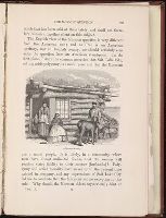
P. 225.
Subject (Geographic):
Southwest, New --Description and travel
Subject (Topic):
Indians of North America --Southwest, New and Pacific railroads --Explorations and surveys
Collection Created:
London, Chapman & Hall, 1869
Found in:
Beinecke Rare Book and Manuscript Library > A Mormon family
Branch:v1.61.8 ,Deployed:2024-06-20T11:14:55-04:00