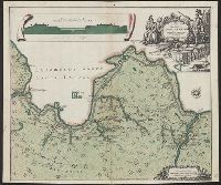
"Cum priv. Sum̄i Vicariat in part. Rheni, Franc., et Suev. juris.", Includes canal profile and ornamental cartouche., Oriented with north toward the upper right., Relief shown by hachures., and Russian and Latin.
Publisher:
M. Seutter,
Subject (Geographic):
Ladoga Lake Region (Russia)--Maps--Early works to 1800
Subject (Topic):
Canals--Russia--Ladoga Lake Region--Maps--Early works to 1800
Russia. Gidrograficheskīĭ departament, creator Russia. Гидрографическій департамент
Published / Created:
1858 Ii︠u︡ni︠a︡.
Call Number:
848cea B45 1858
Container / Volume:
BRBL_00635
Image Count:
1
Resource Type:
Maps, Atlases & Globes
Alternative Title:
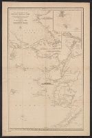
Меркаторская карта Ледовитаго и Берингова морей с сѣверозападнымъ Беренгом Америки : отъ мыса Лисбурна до полуострова Аляски / составлена из разныхъ журналовъ и картъ и гравирована въ Гидрографическомъ департаментѣ Морскаго министерства, 1852.
Description:
"1455" in lower right corner., "No. 6, Vostochnago Okeana" above neat line., Insets: I︠A︡kornoe mi︠e︡sto i osva. Shamisso -- Port K, Mounted on linen., Publishing date in lower left corner., and Relief shown by hachures and spot heights. Depths shown by soundings.
Publisher:
[Morskoe ministerstvo],
Subject (Geographic):
Alaska--Maps, Bering Sea--Maps, Chukchi Peninsula (Russia)--Maps, and Chukchi Sea--Maps
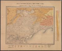
Carte géologique générale de la Russie d'Europe. and Общая геологическая карта европеиІскоиІ России. Лист 48. Мелитополь, Бердянскъ, Перекопъ, Бериславлъ / составиль Н. Соколовъ = Carte géologique générale de la Russie d'Europe. Feuille 48. Melitopol, B
Description:
Mounted on linen.
Publisher:
Kartograficheskoe zavedenie A. Nlʹina, and Картографическое заведение А. Нльина,
Soviet Union. Glavnoe upravlenie geodezii i kartografii
Published / Created:
c1973.
Call Number:
352j 1905
Container / Volume:
BRBL_00111
Image Count:
2
Resource Type:
Maps, Atlases & Globes
Description:
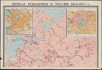
"G-1704." and Insets: 9 i︠a︡nvari︠a︡ 1905 g. v. S.-Peterburge.--Dekabrśkoe vooruzhennoe vosstanie v Moskve (9-18. XII 1905 g.).--Aziatskai︠a︡ chast ́Rossii.
Soviet Union. Glavnoe upravlenie geodezii i kartografii Soviet Union. Главное управление геодезии и картографии
Published / Created:
1954
Call Number:
35j 1905
Container / Volume:
BRBL_00103
Image Count:
2
Resource Type:
Maps, Atlases & Globes
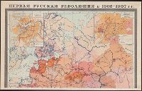
Alternative Title:
Первая русская революция в 1905-1907 гг. / карта составлена Научно-редакционной картосоставительской частью ГУГК в 1940 г. ; автор--Федоров К.М. ; ответственный редактор--Кучборская Е.П.
Description:
"G-299"., Insets: 9-oe i︠a︡nvari︠a︡ 1905 g. v Peterburge -- Dekabrʹskoe vooruzhennoe vosstanie v Moskve (7-17 dekabri︠a︡ 1905 g.) -- Revoli︠u︡t︠s︡ionnoe dvizhenie v Aziatskoĭ chasti Rossii., and Insets: 9-ое января 1905 г. в Петербурге -- Декабрьское вооруженн
Publisher:
Glavnoe upravlenie geodezii i kartografii MVD SSSR, and Главное управление геодезии и картографии МВД СССР,