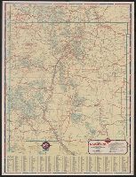
North Dakota, South Dakota, North Dakota, South Dakota, official road map, Phillips Petroleum Company 1938 official road map, North Dakota, South Dakota, and Phillips Petroleum Company official road map, United States.
Description:
"365-J C" and "L-1.", "Phillips Petroleum Company official road map, United States" (scale [ca. 1:10,137,600]), road map of "Black Hills region, South Dakota," 4 local route maps, text, and ill. on verso., Indexed., and Relief shown by hachures.
Publisher:
H.M. Gousha,
Subject (Geographic):
North Dakota--Maps and South Dakota--Maps
Subject (Name):
Phillips Petroleum Company
Subject (Topic):
Roads--North Dakota--Maps and Roads--South Dakota--Maps
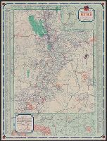
1938 road map, United States., New Mexico, New Mexico, Standard stations road map, Road map, New Mexico, Road map, United States., Standard stations road map, New Mexico, and United States.
Description:
Distance chart, ill., index to points of interest, text, 2 local route maps, and "1938 road map, United States" (scale [ca. 1:10,500,000]) on verso., In lower right: L-1., Indexed., and Relief shown by hachures and spot heights.
Publisher:
H.M. Gousha,
Subject (Geographic):
New Mexico--Maps
Subject (Name):
Standard Oil Company of Texas
Subject (Topic):
Express highways--United States--Maps and Roads--New Mexico--Maps
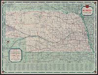
Nebraska, Nebraska official road map, and Phillips Petroleum Company 1939 official road map, Nebraska
Description:
"339 J.C. 10-M.", "Phillips Petroleum Company official road map, United States" (scale [ca. 1:10,137,600]), text, and col. ill. on verso., Indexed., and Relief shown by hachures and spot heights.
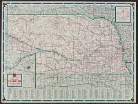
Nebraska, Nebraska official road map, and Phillips Petroleum Company 1942 official road map, Nebraska
Description:
"339 J.C. 10-P.", "Phillips Petroleum Company official road map, United States," text, and col. ill. on verso., Indexed., and Relief shown by hachures and spot heights.
" ... prepared for free distribution by the State Highway Commission of Kansas.", 16 local route maps, text, distance table, and color ill. on verso., and Includes mileage map, index, and text.
Also shows Amerindian reservations: Cayuga Reservation -- Onondago Reservation -- Oneida Reservation., Imperfect: mutilated. Backed with paper., Includes note describing the numbering of military-township lots., and Shows property tract boundaries, town (militar
Publisher:
[publisher not identified],
Subject (Geographic):
New York (State)--Administrative and political divisions--Maps--Early works to 1800, New York (State)--Upstate New York, and Upstate New York (N.Y.)--Administrative and political divisions--Maps--Early works to 1800
Subject (Name):
Tiebout, Cornelius, 1777-1832
Subject (Topic):
Administrative and political divisions, Indian reservations--New York (State)--Maps--Early works to 1800., Landowners--New York (State)--Maps--Early works to 1800., and Landowners--New York (State)--Upstate New York--Maps--Ear