Skip to search
Skip to main content
Skip to first result
Search
You Searched For
Extent of Digitization
Completely digitized
Genre
Engravings
Genre
Maps in books
New Search
Search Results
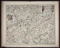
Creator:
Published / Created:
ao. 1761
Call Number:
1983 Folio 23
Collection Title:
[Atlas factice of 50 maps, primarily by Johann Baptist Homann and/or issued by the Homann Erben
Image Count:
1
Publisher:
Edita sumtibus Homannianorum Heredum
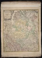
Subject (Geographic):
Bremen (Germany : Duchy) --Maps --Early works to 1800, Hannover (Germany : Province) --Maps --Early works to 1800, Lower Saxony (Germany) --Maps --Early works to 1800, and Westphalia (Germany) --Maps --Early works to 1800
Collection Created:
[Nuremberg : Homann Erben, 1710-1786]
Found in:
Beinecke Rare Book and Manuscript Library > Circuli Westphaliae [cartographic material]: quoad partem septentrionalem in suos Status ecclesiasticos & seculares divisi tabula geographica
Creator:
Published / Created:
1734
Call Number:
1975 Folio 31
Collection Title:
[Atlas factice of 42 maps, produced by the Homann Erben firm]
Image Count:
1
Publisher:
Homann Erben
Subject (Geographic):
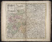
Saxony (Germany) --Maps --Early works to 1800
Subject (Topic):
Atlases, German --Early works to 1800
Collection Created:
[Nuremberg,
Found in:
Beinecke Rare Book and Manuscript Library > Circuli supe. Saxoniae pars meridionalis [cartographic material] : sive ducatus, electoratus et principatus Ducum Saxoniae / ex Zolmannianis et Zuernerianis subsidijs designata et edita per Homannianos Heredes
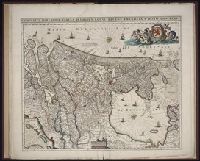
Creator:
Published / Created:
1757
Call Number:
1973 Folio 30
Collection Title:
[Atlas factice of 32 maps and 1 distance table, produced by the Homann Erben firm]
Image Count:
2
Subject (Geographic):
Saxony (Germany) --Maps --Early works to 1800
Subject (Topic):
Atlases, German --Early works to 1800
Collection Created:
[Nuremberg : s.n., 1701-1760]
Found in:
Beinecke Rare Book and Manuscript Library > Circuli supe. Saxoniae pars meridionalis sive Ducatus, Electoratus et Principatus Ducum Saxoniae / [cartographic material] / ex Zolmannianis et Zuå¬rnerianis subsidijs designata et edita per Homannianos Heredes
Creator:
Published / Created:
1715?
Call Number:
1973 Folio 30
Collection Title:
[Atlas factice of 32 maps and 1 distance table, produced by the Homann Erben firm]
Image Count:
2
Publisher:
[Johann Baptist Homann]
Subject (Geographic):
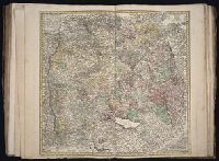
Saxony (Germany) --Maps --Early works to 1800
Subject (Topic):
Atlases, German --Early works to 1800
Collection Created:
[Nuremberg : s.n., 1701-1760]
Found in:
Beinecke Rare Book and Manuscript Library > Circulus Saxoniae inferioris in omnes suos status et principatus / [cartographic material] / accurate divisus ex conatibus Io. Bapt. Homanni
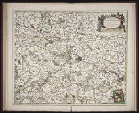
Creator:
Published / Created:
ca. 1743
Call Number:
1983 Folio 23
Collection Title:
[Atlas factice of 50 maps, primarily by Johann Baptist Homann and/or issued by the Homann Erben
Image Count:
1
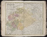
Alternative Title:
Cercle de Suabe, Cercle de Svabe, and Circuli Sueviae mappa
Publisher:
[Homann Erben]
Subject (Geographic):
Baden-Wuerttemberg (Germany) --Maps --Early works to 1800
Collection Created:
[Nuremberg : Homann Erben, 1710-1786]
Found in:
Beinecke Rare Book and Manuscript Library > Circvli Sveviae mappa / [cartographic material] / ex subsidijs Michalianis delineata & a Dno. I.M. Hasio M.P.P. quoad accuratam singulorums statuum determinationem emendata & ad. L. magis legitimae project. reducta ; opus sum[m]i geographi posthumum, & ad
Creator:
Published / Created:
ca. 1684
Call Number:
Folio 469
Collection Title:
[Atlas factice of 13 maps by Nicolaes Visscher I, Nicolaes Visscher II, Guillaume Sanson, and
Image Count:
1
Publisher:
Nicolaes Visscher
Subject (Geographic):
Europe --Maps --Early works to 1800 and Hainaut (Belgium) --Maps --Early works to 1800
Subject (Topic):
Atlases, Dutch --Early works to 1800
Collection Created:
1677-1692
Found in:
Beinecke Rare Book and Manuscript Library > Comitatus Hannoniae et Archiepiscopatus Cameracensis tabula / [cartographic material] / per Nicolaum Visscher
Creator:
Published / Created:
ca. 1680
Call Number:
Folio 469
Collection Title:
[Atlas factice of 13 maps by Nicolaes Visscher I, Nicolaes Visscher II, Guillaume Sanson, and
Image Count:
1
Publisher:
Justus Danckerts
Subject (Geographic):
Europe --Maps --Early works to 1800 and Netherlands --Maps --Early works to 1800
Subject (Topic):
Atlases, Dutch --Early works to 1800
Collection Created:
1677-1692
Found in:
Beinecke Rare Book and Manuscript Library > Comitatus Hollandiae tabula / [cartographic material] / pluribus locis recens emendata a Iusto Danckerts
Creator:
Published / Created:
ca. 1684
Call Number:
Folio 469
Collection Title:
[Atlas factice of 13 maps by Nicolaes Visscher I, Nicolaes Visscher II, Guillaume Sanson, and
Image Count:
1
Publisher:
Nicolaes Visscher
Subject (Geographic):
Europe --Maps --Early works to 1800 and Namur (County) --Maps --Early works to 1800
Subject (Topic):
Atlases, Dutch --Early works to 1800
Collection Created:
1677-1692
Found in:
Beinecke Rare Book and Manuscript Library > Comitatus Namurci / [cartographic material] / emendata delineatio nuperrime in lucem edita per Nicolaum Visscher
Creator:
Published / Created:
1750
Call Number:
1973 Folio 30
Collection Title:
[Atlas factice of 32 maps and 1 distance table, produced by the Homann Erben firm]
Image Count:
2
Publisher:
[Matthaeus Seutter?]
Subject (Geographic):
Nordhausen (Germany : Landkreis) --Maps --Early works to 1800
Subject (Topic):
Atlases, German --Early works to 1800
Collection Created:
[Nuremberg : s.n., 1701-1760]
Found in:
Beinecke Rare Book and Manuscript Library > Comitatus Stolbergensis delineatio geographia, Praefecturas Hohnstein, Stolberg, Hayn Berenroda, Ebersburg, Ufftrungen, Rosla et Questen cum limitibus et vicinia accurate exhibens / [cartographic material] / caelo Matthaei Seutteri. Georgraphi Caesarei ;
Creator:
Published / Created:
a. 1760
Call Number:
1973 Folio 30
Collection Title:
[Atlas factice of 32 maps and 1 distance table, produced by the Homann Erben firm]
Image Count:
2
Alternative Title:
Comitatus Schoenburgensis
Publisher:
Edentibus Homannianis Heredibus
Subject (Geographic):
Zwickau (Germany : Landkreis) --Maps --Early works to 1800
Subject (Topic):
Atlases, German --Early works to 1800
Collection Created:
[Nuremberg : s.n.,
Found in:
Beinecke Rare Book and Manuscript Library > Comitatvs Schoenburgensis [cartographic material] : in quo celsissimorum comitum de Schoenburg regiones ad circulum Saxoniae superiorem Imperii Romano-Germanici pertinentes et in Marchionatu Misniae sitae, subfeuda porro Bohemico-Imperialia, nempe Dynasti
Branch:v1.61.8 ,Deployed:2024-06-20T11:15:02-04:00