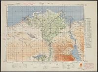
"This sheet is gridded with 'red' grid based on Long. 31° E.", English and Arabic., Geographic coverage of E, Includes index to adjoining sheets and "List of permanent water supplies.", Map no. A384., and Relief shown by gradient tints, hachures, and spot heights.
Chiefly in English. Some place names given also in Arabic., "Constructed from trigonometrical survey in the spring of 1852 at the command of the government of India.", Relief shown by shading., Includes cuneiform inscriptions., and University of Chicago copy signed: True copy of the original, Felix Jones. Baghdad 15th July 1852.
Publisher:
John Walker
Subject (Geographic):
Nineveh (Extinct city), Calah (Extinct city), and Mosul (Iraq)
Qazwīnī, Zakarīyā ibn Muḥammad, 1208 or 9-1283 or 4.
Published / Created:
[15--?]
Call Number:
Arabic MSS 575
Image Count:
2
Resource Type:
Maps, Atlases & Globes
Abstract:
In the center of the map is Mecca; the ocean is located on each side along the outer edge of the sheet with the pillars of the earth in the four corners. Great emphasis is placed on Africa and the Nile river. Other places of interest include: Wasteland where nobody lives, Mountains of the Moon, Land of the Slavs and Franks, Gog and Magog, Land of the Turks (Central Asia), Red Sea (rectangular water mass), the Source of life.
Description:
Gift of Thomas E. Marston, Yale '27, in honor of Alexander O. Vietor, Yale '36, in November 1978., Removed from a bound volume., and Tempera and ink.