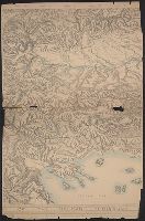
"Approximate scale in center of diagram 1:150,000, vertical exaggeration about 1 1/2 times.", 11hcf 1919E: Hand col. Sheet 1 with typed descriptive notes attached., and Relief shown by shading, land form drawing, hachures and spot heights.
Publisher:
American Geographical Society,
Subject (Geographic):
Friuli (Italy)--Maps, Istria (Croatia and Slovenia)--Maps, and Trieste Region (Italy)--Maps
Subject (Topic):
Block diagrams--Friuli (Italy : Province) and Block diagrams--Istria (Croatia and Slovenia)
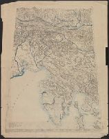
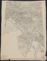
"Approximate scale in center of diagram 1:150,000, vertical exaggeration about 1 1/2 times.", Relief shown by shading, land form drawing, hachures and spot heights., and Western sheet wanting.
Publisher:
American Geographical Society,
Subject (Geographic):
Friuli (Italy)--Maps, Istria (Croatia and Slovenia)--Maps, and Trieste Region (Italy)--Maps
Subject (Topic):
Block diagrams--Friuli (Italy : Province) and Block diagrams--Istria (Croatia and Slovenia)
Fire insurance map, colored to show building construction, property boundaries and house and block numbers.
Alternative Title:
Aug. 1923, Bridgeville, Del. and Bridgeville, Del.
Description:
Coordinates not present on map and are approximated., Sheet 1 includes key to building colors and other features of construction, water facilities and fire department, index map for the adjoining sheets, and information about updates., Stamps below title: 427,0, Oct. 22, 1923., and Title from sheet 1.
Publisher:
Sanborn Map Company,
Subject (Geographic):
Bridgeville (Del.)--Maps.
Subject (Topic):
Fire risk assessment--Delaware--Bridgeville--Maps. and Real property--Delaware--Bridgeville--Maps.
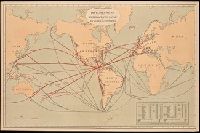
Includes "Table showing distances in miles between commercial ports of the world and distances saved by the Nicaragua Canal." and Shows "present routes" in black and "new routes via Nicaragua canal" in red.
Publisher:
Julius Bein & Co., Photo. Lith.,
Subject (Geographic):
Nicaragua Canal (Nicaragua)--Maps. and Nicaragua--Nicaragua Canal
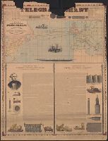
Incl. ill., 2 texts: [1.] Account of the invention and operation of the magnetic telegraph -- [2.] Description of making and laying submarine telegraph cables.
Publisher:
H.H. Lloyd & Co.,
Subject (Geographic):
Atlantic Ocean--Maps
Subject (Topic):
Cables, Submarine--Atlantic Ocean--Maps and Telegraph cables--Atlantic Ocean--Maps